
Maxent (Ille-et-Vilaine)
| Maxent | ||
|---|---|---|
.svg)
|
|
|
| region | Brittany | |
| Department | Ille-et-Vilaine | |
| Arrondissement | Rennes | |
| Canton | Montfort-sur-Meu | |
| Community association | Brocéliande | |
| Coordinates | 47 ° 59 ′ N , 2 ° 2 ′ W | |
| height | 51-137 m | |
| surface | 39.72 km 2 | |
| Residents | 1,466 (January 1, 2017) | |
| Population density | 37 inhabitants / km 2 | |
| Post Code | 35380 | |
| INSEE code | 35169 | |

Maxent is a commune in Brittany in France . It belongs to the department of Ille-et-Vilaine , the Arrondissement Rennes and the canton of Montfort-sur-Meu . It borders in the northwest on Plélan-le-Grand , in the northeast on Treffendel , in the east on Baulon , in the southeast on Bovel , in the south on Campel and in the southwest on Maure-de-Bretagne and Loutehel . The settlement area is on average 110 meters above sea level.
Population development
| year | 1962 | 1968 | 1975 | 1982 | 1990 | 1999 | 2008 | 2013 |
|---|---|---|---|---|---|---|---|---|
| Residents | 1209 | 1149 | 1087 | 982 | 980 | 1040 | 1263 | 1422 |
Attractions
See also: List of Monuments historiques in Maxent (Ille-et-Vilaine)
- Hayes Castle and Saint-Maxent Fountain, both from the 19th century

Former church

Saint-Maxent Church
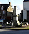
War memorial
_Ancienne_%C3%A9glise.JPG)
_%C3%89glise_01.JPG)
_Monument_aux_morts.JPG)
literature
- Le Patrimoine des Communes d'Ille-et-Vilaine. Flohic Editions, Volume 2, Paris 2000, ISBN 2-84234-072-8 , pp. 1100-1102.
Web links
Commons : Maxent - collection of images, videos and audio files