
Gévezé
|
Gévezé Gevrezeg |
||
|---|---|---|
.svg)
|
|
|
| region | Brittany | |
| Department | Ille-et-Vilaine | |
| Arrondissement | Rennes | |
| Canton | Melesse | |
| Community association | Rennes metropolis | |
| Coordinates | 48 ° 13 ′ N , 1 ° 47 ′ W | |
| height | 38-109 m | |
| surface | 27.54 km 2 | |
| Residents | 5,301 (January 1, 2017) | |
| Population density | 192 inhabitants / km 2 | |
| Post Code | 35850 | |
| INSEE code | 35120 | |
| Website | http://www.ville-geveze.fr/ | |
 Mairie from Gévezé |
||

Gévezé ( Breton : Gevrezeg ; Gallo : Jaebevae ) is a French municipality with 5301 inhabitants (as of January 1 2017) in the Ille-et-Vilaine in the region of Brittany . It belongs to the Arrondissement of Rennes and the Canton of Melesse .
geography
Gévezé is located on the Flume River , a tributary of the Vilaine . Neighboring municipalities of Gévezé are Langouet in the north, Vignoc in the northeast, La Mézière in the east, Rennes in the southeast, Le Rheu and Pacé in the south, Saint-Gilles and Parthenay-de-Bretagne in the southwest, Romillé in the west and Langan in the northwest.
Population development
| year | 1962 | 1968 | 1975 | 1982 | 1990 | 1999 | 2006 | 2017 |
| Residents | 1343 | 1327 | 1650 | 1983 | 2434 | 2759 | 3393 | 5301 |
Attractions
- Church of Sainte-Justine from the 11th century, with alterations from the 16th to 21st centuries. century
- Beauvais Castle, built in the 17th century on the site of a 15th century mansion, monument historique since 1956
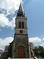
Sainte-Justine Church
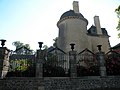
Beauvais Castle


literature
- Le Patrimoine des Communes d'Ille-et-Vilaine. Flohic Editions, Volume 2, Paris 2000, ISBN 2-84234-072-8 , pp. 1200-1203.
Web links
Commons : Gévezé - collection of images, videos and audio files