
Médréac
| Médréac | ||
|---|---|---|
|
||
| region | Brittany | |
| Department | Ille-et-Vilaine | |
| Arrondissement | Rennes | |
| Canton | Montauban-de-Bretagne | |
| Community association | Saint-Méen Montauban | |
| Coordinates | 48 ° 16 ′ N , 2 ° 4 ′ W | |
| height | 45-137 m | |
| surface | 35.02 km 2 | |
| Residents | 1,827 (January 1, 2017) | |
| Population density | 52 inhabitants / km 2 | |
| Post Code | 35360 | |
| INSEE code | 35171 | |
_Mairie.jpg) City Hall (Mairie) of Médréac |
||

Médréac is a French commune with 1,827 inhabitants (at January 1, 2017) in the department of Ille-et-Vilaine in the region of Brittany ; administratively it belongs to the Arrondissement Rennes and is part of the canton of Montauban-de-Bretagne . The inhabitants are called Médréaciens .
geography
Médréac is about 33 kilometers northwest of Rennes . Médréac is surrounded by the neighboring municipalities of Guitté in the north and north-west, Plouasne in the north-east, Saint-Pern in the east, Landujan in the east and south-east, Montauban-de-Bretagne and Saint-M'Hervon in the south, Quédillac in the south-west and La Chapelle-Blanche in the West.
Population development
| year | 1962 | 1968 | 1975 | 1982 | 1990 | 1999 | 2006 | 2013 |
| Residents | 1,654 | 1,631 | 1,556 | 1,512 | 1,460 | 1,495 | 1,758 | 1,836 |
| Source: Cassini and INSEE | ||||||||
Attractions
See also: List of the Monuments historiques in Médréac
- Alignments of Lampouy , megaliths and menhirs
- Saint-Pierre church
- Grand crosses in the cemetery
- Entrance building of the station

View of Médréac

Menhir La Roche Carrée
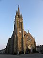
Saint-Pierre church

Entrance building of the station


_%C3%89glise_Saint-Pierre.jpg)

literature
- Le Patrimoine des Communes d'Ille-et-Vilaine. Flohic Editions, Volume 2, Paris 2000, ISBN 2-84234-072-8 , pp. 950-959.