
Saint-Gonlay
|
Saint-Gonlay Sant-Gonlei |
||
|---|---|---|
|
||
| region | Brittany | |
| Department | Ille-et-Vilaine | |
| Arrondissement | Rennes | |
| Canton | Montfort-sur-Meu | |
| Community association | Montfort Community | |
| Coordinates | 48 ° 7 ′ N , 2 ° 4 ′ W | |
| height | 38-95 m | |
| surface | 9.26 km 2 | |
| Residents | 354 (January 1, 2017) | |
| Population density | 38 inhabitants / km 2 | |
| Post Code | 35750 | |
| INSEE code | 35277 | |
| Website | http://www.inet-bretagne.fr/com/stgonlay | |

Saint-Gonlay ( Breton : Sant-Gonlei ) is a French municipality with 354 inhabitants (as of January 1 2017) in the department of Ille-et-Vilaine in the region of Brittany ; it belongs to the Arrondissement of Rennes and the canton of Montfort-sur-Meu . The inhabitants are called Gonlaisiens .
geography
Saint-Gonlay is about 29 kilometers west of Rennes . The Meu , which forms the northern boundary of the municipality, and its tributary Comper flow through the municipality . Saint-Gonlay is surrounded by the neighboring municipalities of Saint-Maugan in the north and northwest, Iffendic in the east, Saint-Malon-sur-Mel in the south and southwest and Bléruais in the south.
Population development
| 1962 | 1968 | 1975 | 1982 | 1990 | 1999 | 2006 | 2012 | |
|---|---|---|---|---|---|---|---|---|
| 376 | 329 | 304 | 296 | 280 | 274 | 325 | 348 | |
| Source: Cassini and INSEE | ||||||||
Attractions
- Saint-Guillaume church from the 16th / 17th centuries Century ( Monument historique )
- Old school, today's museum of local history
- La Châsse Castle, destroyed during the Huguenot Wars in 1595, rebuilt in the 17th century
- 18th century mansion of Le Vilou
- Changée Manor
- Bridge Jean over the Meu and Bridge Hervil over the Comper

Saint-Guillaume Church
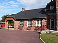
Old school house

.JPG)
literature
- Le Patrimoine des Communes d'Ille-et-Vilaine. Flohic Editions, Volume 2, Paris 2000, ISBN 2-84234-072-8 , pp. 994-995.
Web links
Commons : Saint-Gonlay - Collection of images, videos and audio files