
Livré-sur-Changeon
|
Livré-sur-Changeon Liverieg-Kenton |
||
|---|---|---|
.svg)
|
|
|
| region | Brittany | |
| Department | Ille-et-Vilaine | |
| Arrondissement | Rennes | |
| Canton | Fougères-1 | |
| Community association | Liffré-Cormier Community | |
| Coordinates | 48 ° 13 ′ N , 1 ° 21 ′ W | |
| height | 59-126 m | |
| surface | 26.37 km 2 | |
| Residents | 1,700 (January 1, 2017) | |
| Population density | 64 inhabitants / km 2 | |
| Post Code | 35450 | |
| INSEE code | 35154 | |
_Mairie.jpg) Town hall (Mairie) of Livré-sur-Changeon |
||

Livré-sur-Changeon ( Breton : Liverieg-Kenton ; Gallo : Livraé ) is a French municipality with 1,700 inhabitants (as of January 1 2017) in the department of Ille-et-Vilaine in the region of Brittany ; it belongs to the Arrondissement of Rennes and the canton of Fougères-1 (until 2015: canton of Liffré ). The inhabitants are called Livréens .
geography
Livré-sur-Changeon is about 28 kilometers east-northeast of Rennes . Livré-sur-Changeon is surrounded by the neighboring communities of Saint-Aubin-du-Cormier in the north and north-west, Mecé in the east, Val-d'Izé in the south and south-east, Dourdain in the south and Liffré in the west.
Population development
| year | 1962 | 1968 | 1975 | 1982 | 1990 | 1999 | 2006 | 2013 |
| Residents | 1,208 | 1,125 | 1,072 | 1,078 | 1.108 | 1,137 | 1,461 | 1,669 |
| Source: Cassini and INSEE | ||||||||
Attractions
- Menhir La Roche Piquée, Monument historique since 1933
- Notre-Dame church from the 11th century with alterations from the 16th, 18th and 19th centuries, since 1926/1982 Monument historique
- Sainte-Anne chapel from 1631
- Saint-Mathurin old chapel
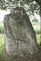
Menhir

Notre-Dame church

_%C3%89glise_Notre-Dame_01.JPG)
literature
- Le Patrimoine des Communes d'Ille-et-Vilaine. Flohic Editions, Volume 1, Paris 2000, ISBN 2-84234-072-8 , pp. 806-811.
Web links
Commons : Livré-sur-Changeon - collection of images, videos and audio files