
Saint-Symphorien (Ille-et-Vilaine)
|
Saint-Symphorien Sant-Sinforian |
||
|---|---|---|
|
||
| region | Brittany | |
| Department | Ille-et-Vilaine | |
| Arrondissement | Rennes | |
| Canton | Melesse | |
| Community association | Val d'Ille-Aubigné | |
| Coordinates | 48 ° 18 ′ N , 1 ° 49 ′ W | |
| height | 51-122 m | |
| surface | 7.5 km 2 | |
| Residents | 603 (January 1, 2017) | |
| Population density | 80 inhabitants / km 2 | |
| Post Code | 35630 | |
| INSEE code | 35317 | |
| Website | http://www.saint-symphorien35.fr/ | |

Saint-Symphorien ( Breton : Sant-Sinforian ) is a French municipality with 603 inhabitants (as of January 1 2017) in the department of Ille-et-Vilaine in the region of Brittany ; it belongs to the arrondissement of Rennes and the canton of Melesse (until 2015: canton of Hédé-Bazouges ).
geography
Saint-Symphorien is located about 22 kilometers north-northwest of Rennes . Saint-Symphorien is surrounded by the neighboring communities of Hédé-Bazouges in the north, Vignoc in the east and south-east, Langouet in the south, Saint-Gondran in the south and south-west, La Chapelle-Chaussée in the west and Saint-Brieuc-des-Iffs in the north-west.
The national route 137 runs through the municipality .
history
From 1973 to 2008 Saint-Symphorien commune associée with the neighboring municipality of Hédé-Bazouges.
Population development
| year | 1962 | 1968 | 1975 | 1982 | 1990 | 1999 | 2008 | 2013 |
| Residents | 351 | 349 | - | - | - | - | 523 | 623 |
| Source: Cassini and INSEE | ||||||||
Attractions
- Saint-Symphorien Church
- Old Town Hall

church
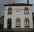
Old Town Hall

