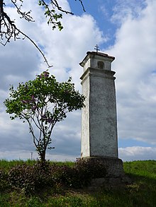
Studnice
| Studnice | ||||
|---|---|---|---|---|
|
||||
| Basic data | ||||
| State : |
|
|||
| Region : | Kraj Vysočina | |||
| District : | Třebíč | |||
| Area : | 390 hectares | |||
| Geographic location : | 49 ° 17 ' N , 16 ° 2' E | |||
| Height: | 485 m nm | |||
| Residents : | 140 (Jan. 1, 2019) | |||
| Postal code : | 675 03 | |||
| License plate : | J | |||
| traffic | ||||
| Street: | Budišov - Rohy | |||
| structure | ||||
| Status: | local community | |||
| Districts: | 1 | |||
| administration | ||||
| Mayor : | Libor Hort (as of 2020) | |||
| Address: | Studnice 2 675 03 Budišov u Třebíče |
|||
| Municipality number: | 591777 | |||
| Website : | www.studnice-tr.cz | |||
Studnice (German Studnitz ) is a municipality in the Czech Republic . It is located seven kilometers south of Velké Meziříčí and belongs to the Okres Třebíč .
geography
Studnice is located on the right side of the Oslava in the Krischanauer Uplands ( Křižanovská vrchovina ) in the south of the Bohemian-Moravian Highlands . Studnická strážnice (510 m nm) rises north of the village. Also in the north, on the other bank of the Oslava, are the remains of the Templštejn castle .
Neighboring towns are Osové , Nesměř and Petráveč in the north, Dolní Heřmanice in the northeast, Oslava and Tasov in the east, Klementice in the southeast, Mihoukovice and Rejdůveň in the south, Kundelov and Budišov in the southwest, Hodov in the west and Rohy in the northwest.
history
Studniez was first mentioned in writing in 1366 when Margrave Johann Heinrich gave the Eywanč , Ocmanice , Studnice and Zahrádka estates , which had fallen back around 1360 after the death of the brothers Sezema and Tobias von Eywanč , to Jan von Meziříč. Regardless of this, Bohuš von Eywanč gave his wife Dorothea 150 marks on Ocmanice and Studnice in the Brno country table in 1371. In 1373 Studnice was recorded in the land boards as the property of Jan Hrb, son of Philipp Hrb on Lovcouvitz and Horenitz near Jemnitz. The descendants of Jan Hrb auf Studnice named themselves after the village and are today as " von Studnitz " one of the oldest still existing Moravian noble families. In the 15th century there was a festival and a courtyard . Since 1749 the place had a community seal and coat of arms. In 1752 the Counts Haugwitz acquired the county of Namiescht .
In 1842 the village of Studnitz or Studnic in the Znojmo district consisted of 19 houses in which 119 people lived . Studnitz remained subject to the Fideikommissgrafschaft Namiescht until the middle of the 19th century .
After the abolition of patrimonial Studnice formed from 1849 a district of the community Hodau in the judicial district of Groß Meseritsch . From 1869 the village belonged to the Groß Meseritsch district . In 1884 the political municipality Studnice was established. The village consisted of 27 houses in 1890 and had 183 inhabitants. Ten years later, the number of houses had remained unchanged, the number of inhabitants had dropped to 175. At the 1921 census, 177 Czechs lived in the 28 houses of the community. In the course of the territorial reform and the repeal of the Okres Velké Meziříčí, the municipality came to the Okres Třebíč on July 1, 1960 . Between 1980 and 1990 Studnice was incorporated into Budišov .
Attractions
- Radicals of the Burg Templštejn ( temple stone ), via the mouth of a stream in the Oslava in Eliášova Myslivna ( Forsthaus Elias ).
- Řihákův mlýn water mill in the Oslava Valley
- chapel
- Marterl on the way to Budišov
Web links
Individual evidence
- ↑ Obec Studnice: Podrobné informace , uir.cz
- ↑ Český statistický úřad - The population of the Czech municipalities as of January 1, 2019 (PDF; 7.4 MiB)
- ^ Gregor Wolny : The Margraviate of Moravia, presented topographically, statistically and historically . Volume III: Znojmo District, Brno 1837, p. 450
- ↑ Chytilův místopis ČSR, 2nd updated edition, 1929, p. 1184 Studně Petrova - Stumpengrund


