
Alken (Lower Moselle)
| coat of arms | Germany map | |
|---|---|---|
.png)
|
Coordinates: 50 ° 15 ' N , 7 ° 27' E |
|
| Basic data | ||
| State : | Rhineland-Palatinate | |
| County : | Mayen-Koblenz | |
| Association municipality : | Rhine-Moselle | |
| Height : | 80 m above sea level NHN | |
| Area : | 8.05 km 2 | |
| Residents: | 659 (Dec. 31, 2019) | |
| Population density : | 82 inhabitants per km 2 | |
| Postal code : | 56332 | |
| Area code : | 02605 | |
| License plate : | MYK, MY | |
| Community key : | 07 1 37 201 | |
| Association administration address: | Bahnhofstrasse 44 56330 Kobern-Gondorf |
|
| Website : | ||
| Local Mayor : | Hans-Walter Escher | |
| Location of the local community Alken in the Mayen-Koblenz district | ||
 |
||


Alken is a municipality in the Mayen-Koblenz district in Rhineland-Palatinate . It belongs to the Rhein-Mosel community , which has its administrative headquarters in Kobern-Gondorf .
geography
Alken is located on the eastern, orographically right bank and on the lower reaches of the Moselle (so-called Terrassenmosel ), six kilometers east of the city of Münstermaifeld . The village extends in an almost 500 m wide valley widening in north-south direction. To the east rises the Burgberg ( 212 m above sea level ), north of the Bleidenberg ( 250 m above sea level ). In terms of natural space, the west of the municipal area with the main town can be assigned to the Lower Moselle Valley, while the completely forested area to the east is largely to the northeast Moselhunsrück . It is structured by steep valleys that are drained by the Alkener Bach and its tributaries, which flow into the Moselle at Alken . At 405 m above sea level NHN , the municipality reaches its highest point on the eastern border . Alken includes the Brunkenhof, Thurant Castle, Quidembaum and Wildenbungert residential areas .
history
Alken was first mentioned as Alkana in the 10th century . The current spelling is documented for the 16th century. It belonged to the Palatinate until the 13th century. Around 1200, Count Palatine Heinrich built Thurant Castle to protect the area . In the period that followed, there were armed conflicts with the electors and archbishops of Cologne and Trier . The high point of the events was a long siege of Thurandt Castle, which finally led to the handover by the Count Palatine to the two archbishops in 1248. Alken became the center of the office of the same name, which was administered jointly by Kurköln and Kurtrier until the end of the 18th century . Various noble families have acted as administrators in the course of history ( Eltz , Boos von Waldeck , Winningen, Schöneck, Ehrenburg (-berg) , Thys von Alken and others). The family of the Lords von Wiltberg (headquarters on the Wildburg in the Hunsrück) was particularly important for Alken.
- Population development
The development of the population of Alken, the values from 1871 to 1987 are based on censuses:
|
|
politics
Municipal council
The local council in Alken consists of twelve council members, who were elected in a personalized proportional representation in the local elections on May 26, 2019 , and the honorary local mayor as chairman.
The distribution of seats in the municipal council:
| choice | SPD | CDU | FWG | total |
|---|---|---|---|---|
| 2019 | - | 5 | 7th | 12 seats |
| 2014 | - | 7th | 5 | 12 seats |
| 2009 | 1 | 7th | 4th | 12 seats |
| 2004 | 2 | 7th | 3 | 12 seats |
FWG = Free Voter Group Alken e. V.
mayor
Hans-Walter Escher (FWG Alken eV) became the local mayor of Alken in 2009. In the direct election on May 26, 2019, he was confirmed in his office for another five years with a share of the vote of 74.82%.
coat of arms
The coat of arms shows a red castle with two towers, one with the Electorate of Trier and one with the coat of arms of the Electorate of Cologne. It refers to the Thurant Castle above Alken .
Community partnerships
Sister cities are the communities of the same name Alken (Belgium) and Alken (Denmark) .
Attractions

- Thurant Castle (castle to be visited)
- old Michaelskirche with ossuary : one of the oldest churches on the Moselle, first documented mention in 1015; Choir frescoes around 1350, frescoes in the nave around 1500, Gothic Madonna Enthroned (14th century), Baroque sculptures. Staircase to the Church as the crossroads created
- new parish church of St. Michael (1849): neo-Gothic hall church in slate stone with St. Michael's altar (baroque, 1708) and St. Mary's altar (replica in baroque style, 1988)
- Castle house of the Archbishops of Trier (around 1350), extended to a castle under the Lords of Wiltberg, rebuilt in the 17th century, privately owned since 1845
- Wiltberg wine cellar with vaulted cellars around 1700
- several historical half-timbered houses in Von-Wiltbergstrasse and Oberstrasse; See also in detail: List of cultural monuments in Alken (Lower Moselle) .
- Parts of the city wall (around 1400): Fallerport (connection to the battlement once via two - preserved - half-timbered floors); Customs tower on the banks of the Moselle (today a restaurant); Relics of another tower at Wiltberg Castle; Keeper's house at the entrance to the village (today a gallery)
- Laacher Hof (Moselstraße 8), built as an estate of the Laach Abbey around 1093, later administrative headquarters, Zehnthof , today a winery; heavily changed structurally
- Malteserhaus, former hospital with gate entrance, spiral stone staircase in the courtyard (now in private ownership); in the stone entrance with the year 1093.
- Stumbling blocks in Alken
Viticulture
Alken belongs to the "Burg Cochem wine-growing area " in the Moselle growing region . Ten wine-growing businesses are active in the village, and the area under vines is 17 hectares. About 81% of the wine grown are white grape varieties (as of 2007).
As in the other wine villages on the Lower Moselle, land consolidation has also taken place in Alken , in which a vineyard area of 6 hectares was prepared machine-friendly below Thurant Castle. The small historical terraces in these areas were demolished. On the rest of the area, the small terraces were either renovated or replaced by new terraces with Grauwacke retaining walls as gabions or dry stone walls. New access routes were built that are also used by tourists. The dream path "Bleidenberger Aussichte" (premium hiking trail) runs through the Alkens vineyards.
In 2005 a red vineyard peach plantation was laid out on a fallow land.
The three Alken vineyards are
- Alkener Bleidenberg
- Alkener Burgberg
- Alkener Hunnenstein
Mainly Riesling is grown , furthermore Kerner , to a lesser extent red grape varieties ( Blauer Spätburgunder and Dornfelder ).
tourism
In the summer half of the year the excursion boats of the passenger shipping company MS Goldstück (Heimat-Hafen Alken), the Cologne-Düsseldorfer and the passenger shipping company Gebr. Kolb dock in Alken.

traffic
Alken is located on the right bank of the Moselle on federal road 49 between Koblenz and Treis-Karden.
To the south of Alken, the Moselle bridge Löf-Alken connects with the federal highway 416 on the left bank of the Moselle .
The Moselle Camino from Koblenz via Stolzenfels to Trier leads through Alken. It is part of the Camino de Santiago to Santiago de Compostela.
photos
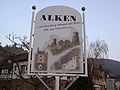
Tourist board at the entrance to the village
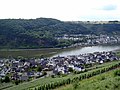
Alken from Thurant Castle

Wiltburg Castle House

Michaelskapelle seen from the Bleidenberg

Thurant Castle from the east


literature
- Ingrid Bodsch : castle and rule. On the territorial and castle policy of the Archbishops von Tier in the High Middle Ages up to the death of Dieter von Nassau († 1307) , Boppard 1989.
- Chronicle of Alken, Mosel: its history - past and present. - [Ed .: Local community Alken / Mosel. Research and version: Josef Schnee]. Alken 2003. 344 pp.: Numerous. Ill. [Without ISBN!]
Web links
- Internet presence of the local community Alken
- Pictures and information about the Michaelskapelle
- Scientific Processing of certificates and documents on Alken (Lower Moselle) (PDF; 58 kB)
- Essays u. a. to the old village school, Laacher Hof, Malteserhaus, Moosemannfest, Wiltburg
- Literature on alkene in the Rhineland-Palatinate state bibliography
Individual evidence
- ↑ State Statistical Office of Rhineland-Palatinate - population status 2019, districts, communities, association communities ( help on this ).
- ↑ State Statistical Office Rhineland-Palatinate (ed.): Official directory of the municipalities and parts of the municipality. Status: January 2019 [ Version 2020 is available. ] . S. 44 (PDF; 3 MB).
- ↑ Elmar Rettinger: On the local history. (PDF; 58 kB) In: Historical local dictionary. Institute for Historical Regional Studies at the University of Mainz eV, p. 1 , accessed on September 27, 2013 .
- ↑ a b State Statistical Office Rhineland-Palatinate - regional data
- ^ Regional Returning Officer Rhineland-Palatinate: Local elections 2019, city and municipal council elections
- ^ The State Returning Officer of Rhineland-Palatinate: direct elections 2019. see Rhein-Mosel, Verbandsgemeinde, first line of results. Retrieved January 7, 2020 .
- ↑ 1000; Anniversary: The history of Michaelskirche was highlighted in: Rhein-Zeitung , May 25, 2015
- ^ Karl-Josef Schäfer, Wolfgang Welter: A Way of St. James from Koblenz-Stolzenfels to Trier: The pilgrim guide for the Mosel-Camino . 4th edition. 2015, ISBN 978-3-8334-9888-6 , pp. 168 . to the homepage of the author Wolfgang Welter, Schweich
- ^ Karl-Heinz Jung: Mosel-Camino (Outdoor Handbook) . 2nd Edition. Conrad Stein Verlag GmbH, Welver 2014, ISBN 978-3-86686-491-7 , p. 96 . Conrad-Stein-Verlag ( Memento from March 4, 2016 in the Internet Archive )

Eight | Alkene | Andernach | Look | Arft | Baar | Bassenheim | Bell | Bendorf | Bermel | Boos | Brey | Brodenbach | Castles | Thieving | Ditscheid | Agree | Ettringen | Gappenach | Low | Gierschnach | Hatzenport | Hausten | Herresbach | Shepherds | Cold | Kaltenengers | Sweeping | Notches | Chained | Kirchwald | Kobern-Gondorf | Kollig | Kottenheim | Kretz | Kruft | Langenfeld | Langscheid | Clay | Lind | Löf | Lonnig | Luxem | Quirks | Mayen | Mendig | Mertloch | Monreal | Mülheim-Kärlich | Münk | Münstermaifeld | Night home | Naunheim | Nickenich | Niederfell | Niederwerth | Nörtershausen | Upper skin | Notice | Pillig | Plaidt | Polch | Reudelsterz | Rhens | Vineyards | Over | Saffy | Sankt Johann | Saint Sebastian | Siebenbach | Spay | Door | Trimbs | Urbar | Urmitz | Vallendar | Virneburg | People's field | Waldesch | Hamlet | Weißenthurm | Weitersburg | Welling | Welschenbach | Wierschem | Winningen | Clouds