
Kirchlengern
| coat of arms | Germany map | |
|---|---|---|

|
Coordinates: 52 ° 12 ' N , 8 ° 38' E |
|
| Basic data | ||
| State : | North Rhine-Westphalia | |
| Administrative region : | Detmold | |
| Circle : | Herford | |
| Height : | 53 m above sea level NHN | |
| Area : | 33.78 km 2 | |
| Residents: | 16,023 (Dec. 31, 2019) | |
| Population density : | 474 inhabitants per km 2 | |
| Postal code : | 32278 | |
| Area code : | 05223 | |
| License plate : | HF | |
| Community key : | 05 7 58 020 | |
| LOCODE : | DE KLG | |
| Community structure: | 7 parts of the community | |
| Address of the municipal administration: |
Rathausplatz 1 32278 Kirchlengern |
|
| Website : | ||
| Mayor : | Rüdiger Meier ( CDU ) | |
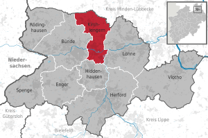
| Location of the municipality of Kirchlengern in the Herford district | ||
 .svg) |
||

Kirchlengern (Low German: (Kirk-) Liörnern ) is a municipality in the East Westphalian district of Herford ( Detmold administrative district ) in the northeast of North Rhine-Westphalia . The community is located around 25 km north of Bielefeld . The municipality of Kirchlengern in its current expansion was only created in a regional reform in 1969, but some districts of the municipality are mentioned in writing for the first time as early as 1150.
geography

Geographical location
The community is located in the Ravensberger Hügelland in the lower Weser Uplands and extends in the northern parts of the municipality to the foothills of the Wiehengebirge . The south of the municipality lies in the lowlands of the Else and Werre , both of which form part of the border to wages in the east and converge exactly on the border to wages. At the confluence is 52 m above sea level. NN height also the lowest point of the community. The highest point is the "Kahle Berg" ( Reesberg ) 148 m above sea level. NN in the south of the municipality. Towards the Wiehengebirge in the north, the terrain rises within the municipal boundaries up to about 123 m above sea level. NN at. The closest major cities are Bielefeld, 25 km to the south, and Osnabrück, 40 km to the west . The community is located 10 km north of the district town of Herford , 5 km west of the city of Löhne and 4 km east of the city of Bünde .
Waters
The Else flows through the municipality from west to east and flows into the Werre , which comes from the southwest on the eastern border , and then drains into the Weser . From the north, the Else and Werre from the Wiehengebirge flow in numerous streams, z. B. the Rehmerloh-Mennighüffer Mühlenbach which flows through the north of the municipality and drains into the Werre in Löhne. Coming from the south, the Brandbach , which also flows through Hiddenhausen and Enger, flows west of the Reesberg towards the Else.
geology

The area naturally belongs to the Ravensberger Mulde . The Ravensberger Mulde is a gently undulating, between 50 and 140 m above sea level. NN lying hill country . Numerous small valleys (so-called sieves ) often cut suddenly and deeply into the otherwise poorly coupled land. Geologically, there are essentially lias plates with loess overlay , which were transformed into hilly areas by the Pleistocene demolition . Under the loess cover there are sometimes bed debris . Another legacy of the Ice Ages are the boulders that are often found . The Elsetal and the lower course of the Werre form the glacial valley of the Else-Werre-Niederung , which runs in a west-east direction .
Kirchlengern is moderately to good, in some locations very good, for the use of geothermal heat sources by means of a geothermal probe and heat recovery through heat pump heating (see the adjacent map).
Expansion and use of the urban area

Kirchlengern extends over an area of 33.78 km², making it the second smallest municipality in the heavily urbanized Herford district after the somewhat smaller Hiddenhausen . The shape of the municipality is 10 km long in north-south direction and a width of max. 6.5 km in east-west direction relatively narrow.
As an old settlement area, Kirchlengern was used for agriculture very early on. Together with the cities of Bünde , Hiddenhausen and Löhne , the southern part of the municipality forms an almost continuous agglomeration . The northern parts of the municipality are less populated, but here, as in the entire municipality, forest is very rare. In the consistently fertile loess areas , grain and maize are increasingly cultivated, but also rapeseed. The following table shows the exact land use
|
Area according to type of use |
Settlement and traffic areas |
Agricultural area |
Forest area |
other open spaces |
|---|---|---|---|---|
| Area in hectares | 941 | 2.126 | 249 | 63 |
| Share of total area | 27.8% | 62.9% | 7.4% | 1.9% |
Neighboring communities
The municipality of Kirchlengern borders in the north on the municipality Hüllhorst ( district Minden-Lübbecke ), in the east on the city of Löhne , in the south on the municipality Hiddenhausen and in the west on the city of Bünde (all in the district of Herford).
Community structure

The community is divided into seven districts, of which Kirchlengern is the largest. He is the namesake of the association that emerged in 1969 from the independent municipalities of the Kirchlengern Office. The previously independent municipality of Südlengern was allocated to the municipality of Kirchlengern (Südlengern-Dorf) and the city of Bünde (Südlengern-Heide) during this reorganization of the Herford district. Oberbehme forms an unofficial district around the Oberbehme estate of the same name .
| District | Population (December 31, 2009) |
Area (km²) |
Density (Ew / km²) |
|---|---|---|---|
| Häver | 1,863 | 5.06 | 368 |
| Kirchlengern | 5,956 | 9.51 | 626 |
| Monastery farmers | 2,482 | 7.28 | 341 |
| Quernheim | 1,548 | 3.86 | 401 |
| Rehmerloh | 195 | 3.03 | 64 |
| Quernheim Abbey | 1,595 | 1.61 | 991 |
| Südlengern | 3,120 | 3.43 | 910 |
climate
The predominant climate is the Atlantic maritime climate . Long-term average climatic data (1971–2000) for Herford , about 10 km from the air, is shown in the table below.
|
Monthly average temperatures and precipitation for Kirchlengern (eigtl. Herford) (1971–2000)
Source: DWD
|
||||||||||||||||||||||||||||||||||||||||||||||||||||||||||||
On a long-term average (1961–1990) the region had an average of 1473 hours of sunshine per year (observation station: Herford). The long-term average of the weather data for Kirchlengern should not differ significantly from the data given from Herford, as the cities are roughly the same height and in a comparable natural area.
history

Even before the 9th century there were first attempts at settlement. The old settlement area on the Else was settled by Saxon Engers , who were then Christianized and subjugated by the Franks under Charlemagne around 800 . The present Kirchlengern community has been mentioned for the first time since the 12th century. Probably in 1147 the Bishop of had Osnabruck , Philip of Katzenelnbogen, the monastery Quernheim as Augustinian - nunnery founded. Its basilica (collegiate church) dates back to the 12th century, but has been rebuilt several times and probably goes back to a previous sacral building. The district of Stift Quernheim is probably one of the first permanent settlements in Kirchlengern. The districts Häver (mentioned as Hevere ), Kirchlengern ( Linegaron ) and Quernheim ( Quernem ) were in the lift roller of Herford mentioned in writing in 1150, 1151 and Südlengern Rehmerloh the late 12th century. Monastery farmers (originally in Low German: Burschop beym Closter) developed as farmers around the monastery in Quernheim Abbey. The name for this part of the village probably did not come up until the 18th century. In the course of the Reformation , the monastery in Quernheim Abbey was converted into a free worldly women's abbey in 1532 . After the Peace of Westphalia in 1648, the Principality of Minden (area north of the Else) and the county of Ravensberg (south of the Else) fell to Brandenburg-Prussia . From 1807 to 1810 the area belonged to the Napoleonic Kingdom of Westphalia . From 1811 to 1813, the entire current municipal area of France was incorporated. In 1813 (officially 1815) it fell back to Prussia. On December 1, 1810, the noble women's monastery in Quernheim was dissolved and its property was transferred to Prussia in 1815 , who administered it as a domain until 1832. In 1832 the district court in Quernheim, founded in 1816, was relocated to Bünde. Local mayor Wilhelm Bacmeister began in 1860 to sell the property of the monastery, which included an estate and a manor, divided into plots. Thus, since 1860, the new settlers from the monastery lands created the 161 hectare community of Stift Quernheim with small houses and small farms.
Around the middle of the 19th century, with the advent of mechanical looms, the purely manual processing of flax fiber collapsed, and there were also poor harvests between 1847 and 1850. A road connection from Herford to Lübbecke via Kirchlengern (today B239) and the construction of a railway line from Löhne in the direction of Osnabrück ( Hannoversche Westbahn , inaugurated in 1855) finally brought economic improvement . Kirchlengern has had a train station since 1855 . From here a cross connection to the Hamm – Minden railway line via Herford and Bielefeld was established in 1904 . Between 1897 and 1937, Kirchlengern was also the final stop on a small railway line to Oberlübbe , which mainly served to transport ore , but also transported people (" Wallücker Willem ").
From 1843 to 1918 Kirchlengern belonged to the Gohfeld - Mennighüffen district , and in 1919 a separate Kirchlengern office was established - the forerunner of today's municipality. In 1929 the previously independent manor districts of Oberbehme and Steinlacke (formerly Herford and Bünde district) were dissolved and became part of the Kirchlengern district.
Incorporations
During the municipal reorganization in North Rhine-Westphalia was on January 1, 1969. the Office Kirchlengern (with Häver , Kirchlengern, Monastery peasantry , Quernheim , Rehmerloh , pen Quernheim and) Südlengern village and small parts of the community Spradow the new community Kirchlengern formed.
Population development
The following table shows the population development since 1969:
| date | Residents |
|---|---|
| 1969 2 | 13,705 |
| 1974 2 | 14,540 |
| 1975 1 | 14,562 |
| 1980 1 | 14,511 |
| 1985 1 | 14,354 |
| 1990 1 | 14,714 |
| 1995 1 | 15,443 |
| 2000 1 | 16,070 |
| 2005 1 | 16,492 |
| 2010 1 | 16,195 |
| 2015 1 | 16,951 |
| 2018 1 | 16,074 |
1 Source: Kirchlengern website / Figures, data, facts.
2 Source: State Office for Statistics
religion

The population is predominantly Protestant (66.7% of the population). Another 8.53% are Roman Catholic . 24.9% of citizens belong to another denomination or are non-denominational.
- Evangelical parishes in the Evangelical Church of Westphalia are the Evangelical Church Congregation Hagedorn, the Evangelical Lutheran Church Congregation Kirchlengern, the Evangelical Lutheran Church Congregation Stift Quernheim and the Evangelical Lutheran Lydia Church Community Bünde for the district of Südlengern.
- The Evangelical Free Church of Kirchlengern is an Evangelical Free Church Congregation.
- Roman Catholic parishes are the parishes of St. Canisius and St. Xaverius in the Quernheim Abbey and St. Marien in the Kirchlengern district, which are part of the Bünder Land pastoral network. The future bishop of the Archdiocese of Paderborn , Matthias König , was pastor here .
- Other New Religious Movements are the New Apostolic Church of the State of North Rhine-Westphalia, and the Kingdom Hall of Jehovah's Witnesses and the Free Bible Congregation Kirchlengern, which were first established in Kirchlengern as a split from Jehovah's Witnesses.
politics

Kirchlengern is a municipality in the Herford district. The county seat is Herford. Kirchlengern's citizens have been electing the mayor in a direct election since 1999. In addition, they elect a municipal council with currently 34 representatives.
Municipal council
The politics of the Kirchlengern municipality is currently shaped by four parties and an electoral association. The municipal council elected in 2009 has 34 members. In addition, the mayor is the council chairman. The following table shows the composition of the council and local election results since 1975:
| Council of the Kirchlengern municipality: share of voters and municipal councils since 1975 | |||||||||||||
|---|---|---|---|---|---|---|---|---|---|---|---|---|---|
|
|
|
|
|
|
total | electoral participation |
|||||||
| Electoral term | % |
|
% |
|
% |
|
% |
|
% |
|
% |
|
% |
| 1975-1979 | 39.37 | 13 | 52.50 | 18th | 8.12 | 2 | 100 | 33 | 88.82 | ||||
| 1979-1984 | 41.62 | 14th | 50.94 | 17th | 7.44 | 2 | 100 | 33 | 77.50 | ||||
| 1984-1989 | 35.46 | 12 | 51.77 | 18th | 9.28 | 3 | 3.48 | 0 | 100 | 33 | 71.97 | ||
| 1989-1994 | 34.51 | 12 | 51.93 | 18th | 8.31 | 2 | 5.25 | 1 | 100 | 33 | 69.78 | ||
| 1994-1999 | 36.41 | 12 | 44.93 | 17th | 12.45 | 4th | 2.31 | 0 | 100 | 33 | 85.19 | ||
| 1999-2004 | 37.62 | 13 | 44.93 | 15th | 17.45 | 6th | - | - | 100 | 34 | 61.30 | ||
| 2004-2009 | 39.74 | 14th | 41.93 | 14th | 14.80 | 5 | 3.53 | 1 | 100 | 34 | 57.44 | ||
| 2009-2014 | 41.61 | 14th | 36.55 | 12 | 8.31 | 3 | 8.12 | 3 | 5.41 | 2 | 100 | 34 | 58.01 |
| 2014-2019 | 45.8 | 15th | 35.2 | 12 | 8.9 | 3 | 8.7 | 3 | 2.4 | 1 | 100 | 34 | 56.2 |
|
Percentages rounded. Sources: State database NRW; State Office for Information and Technology NRW ; Municipal data center Minden-Ravensberg / Lippe
UWG: Independent community of voters |
|||||||||||||
mayor
Kirchlengern's mayor is Rüdiger Meier ( CDU ), who was directly elected by the citizens of the community for the first time on September 26, 2004 with 56.17 percent. On August 30, 2009, he was confirmed in office with 60.30 percent. In 2014, Rüdiger Meier was re-elected with 65.2 percent of the vote. His predecessor was Werner Helmke ( SPD ), who was elected in a runoff election in 1999 with 58.7 percent of the valid votes. Further predecessors:
- Friedrich Hartmann (around 1975)
- August Renken (around 1978)
- Heinrich Stüwe
- Rolf Breitenbürger
- Günter Schröder
- Werner Helmcke
coat of arms
The municipality of Kirchlengern was granted the right to use a coat of arms in a certificate from the District President in Detmold dated February 15, 1972. It shows a shield divided by red and silver; above three acorns growing out of a stem, below a red bar. The three silver acorns placed in the upper Minden red field indicate the former trade association of the Quernheimer Mark. The boundaries of the same coincide after the exclusion of the municipality of Spradow essentially with those of the previous office of Kirchlengern, which had an identical coat of arms. Red is the color of the Minden territory. Silver points to historical and territorial-neighborly relations with the county of Ravensberg , with which the territory of Minden has formed an administrative province of the Brandenburg-Prussian state since 1719, and to the fact that the community belongs to the Wittekindkreis Herford.
The municipality of Kirchlengern was also granted the right to fly a flag with a certificate from the District President in Detmold dated February 15, 1972. It is streaked lengthways with red and white.
Twin cities
Tännesberg in the Upper Palatinate district of Neustadt an der Waldnaab in Bavaria has been a partner municipality since 1982. The place has around 1500 inhabitants.
Culture
theatre
Kirchlengern does not have a theater, but the Kirchlengern community's cultural program "Culture in the Forum" at the Erich Kästner comprehensive school in Kirchlengern. The local cinema Lichtblick shows films away from the mainstream on a screen only 2.50 by 6 meters, 8 weeks after the national launch at the earliest. The audience can have a say in the program through their wishes.
Museums
.jpg)
In the fire museum in the district Häver be issued to over 1000 m² historic fire department uniforms, equipment and Spritzenwagen the fire department. The departments respiratory protection, uniform, awards and medals, water pumping and motorization are clearly structured. The highlights of the collection are the vehicles and turntable ladders, all of which are ready for use. The fire department museum in a converted farmhouse from the 18th century can be visited every first and last Sunday of the month. The Bauernbad Rehmerloh is a historic bathing and lodging house from 1883. At that time it served as a public cleaning bath for the rural population. Most of them bathed on weekends, so that during the week therapeutic baths with "healthy" bath additives are carried out. It was in operation until 1973 and renovated from 1996 to 2002 and has been open to visitors as a museum ever since.
music
A local group of the music-related Christian organization Ten Sing is located in Südlengern . There are also u. a. the Gospel Choir Kirchlengern eV, the Evangelical Church Choir Kirchlengern, the men's choir MGV 1898 Stift Quernheim and the trombone choir of the CVJM Kirchlengern. The Kirchlengern music school is located in the old primary school building, not far from the town hall.
Buildings
Kirchlengern has a total of 35 listed monuments, including:
Collegiate church

The collegiate church in Quernheim Abbey is essentially a Romanesque building from the 12th century . In the 16th century the central nave was extended to the north in the late Gothic style and re-vaulted. The church is the nucleus of Kirchlengern, a former monastery and women's monastery. A multi-part late Gothic winged altar from around 1525 is very impressive .
Mansion

Right next to the collegiate church stands the abbess's house, known as the “mansion”, dating from 1676. It was built as a residence for around 30 heads of the women's monastery in Quernheim. The monastery was dissolved in 1810 in the course of secularization and initially continued as a Prussian state domain. In 1832 Prussia sold to Commissioner Conrad Delius in Minden and Delius handed the manor house to his son-in-law, Major a. D. Wilhelm Bacmeister zu Grapenstein (1791–1874). He lived in the building until 1861 and had it extended by 6.5 m in 1837. In 1861, because of Bacmeister's financial worries, it was sold to the cigar manufacturer Steinmeister & Wellensiek , who expanded the house again and set up a cigar factory. It was used until 1971 and was about to be demolished in 1976. The Ravensberg Biological Station in the Herford district has been located in the manor house since 1993. Weddings have also been held since 1998 in a room with a historic ceiling painting.
Gut Oberbehme and Gut Steinlake
The moated castle or Gut Oberbehme was first mentioned in 1450. It belonged to the von Quernheim family until the 17th century. In 1734 Friedrich von der Horst zu Haldem bought the estate from the von Cornberg brothers . In close proximity was the Niederbehme estate, which until the 19th century belonged to the von Quernheim family who also owned the Ulenburg estate in Löhne. That caused disputes. Only one year after the acquisition, the baron von der Horst left the buildings of Oberbehme to the Lord von Quernheim zu Niederbehme and built a new manor building in Gut Steinlake . The rights from Oberbehme were transferred to Steinlake, while the rights from Niederbehme, whose buildings were demolished, were transferred to Oberbehme. For this purpose, demolition material from the Niederbehme estate could also be used for the Steinlake estate.
The baroque-style manor Steinlake , laid out in 1735 by Friedrich von der Horst zu Haldem, has been owned by the Borries family since 1789 . In 1789 Julius August von der Horst sold Steinlacke to Franz Christian von Borries. In 1803 it went to Philipp von Borries, whose descendants still own it today. The property was once 170 hectares. Today Dr. Reyner von Borries in the manor house of the Steinlake manor. He leased the rest of the property. A park belongs to the estate.
Otto the scrap man
Known under the name of Otto the Scrap Man, the sculpture was both a work of art and an advertising medium for a petrol station chain. The over 10 meter high colossus made of scrap, clearly recognizable as a man, was initially in Hiddenhausen and then moved on to Kirchlengern-Häver. At the beginning of 2007, the storm Kyrill and its exposed location on the Hüller Berg were his undoing. He buckled and almost fell on the gas station.
Other structures
- Ostermeiers Hof is a typical Westphalian hall house in the heart of Kirchlengern. The premises of the former Ostermeiers Hof farmhouse serve the public as both a cultural meeting center and the community library.
- Hof Tiemeier in the Südlengern district is also a Westphalian hall building. It dates from 1605, making it one of the oldest surviving farmhouses in Kirchlengern and beyond.
- The Brausemühle was one of the first power plants in the Elsetal and supplied Süd- and Kirchlengern with electricity. The young master miller Heinrich Schürmann, who was born in the Nienburger Mühle in Bünde-Hunnebrock in 1872, learned about water turbines at the milling school in Leipzig . In 1898 he married into the mill and took over the management of the mill from his father-in-law. Heinrich Schürmann installed the first dynamo behind the water turbine on the shower mill in 1902. He then invited to a public demonstration of the carbon filament lamp in the Rabe station restaurant. The first lines were drawn from the brewery mill to the Heinecke cigar factory in Kirchlengern. A second line led to the Wöhrmann bakery and, at the instigation of the head teacher Kirchhoff, to the Südlengern-Dorf school.
- The construction of the Elsetal bridge supported with concrete pillars over the valley and the motorway was documented in the program with the mouse . A camera on the roof of the neighboring power plant took a photo of the construction progress every day, which was then shown in fast motion . The bridge was built using the so-called incremental launching method with a front end , i.e. it was pushed over the piers from one side in stages.
Parks and nature reserves


In the north there is a 5-star Nordic walking park with circular paths of 4 to 18 km. A 4-hectare park with a broad lawn axis and large solitary trees belongs to the Steinlake manor. The park has been preserved in its 19th century state. There is a 1.6 m long whale rib in the park.
In Kirchlengern, parts of the Rehmerloh-Mennighüffer Mühlenbach and the Elseauen are protected. A total of around 240.1 hectares are under nature protection, which corresponds to around 7.13% of the municipal area.

Since 2012, a community forest has existed on a community-owned area near the sewage treatment plant in the district of Häver, in which citizens can sponsor trees. So far, 64 trees (as of 2015) have been planted here for special occasions such as weddings, anniversaries, baptisms or big birthdays. You can choose from sycamore maple , hornbeam , red beech , red oak , pedunculate oak , wild cherry and winter linden .
Sports
General

The sports clubs include TV Häver for popular sports, the tennis club TSG Kirchlengern-Randringhausen , the fencing club Quernheimer FC , the chess club SGEM Kirchlengern and the football clubs VfL Klosterbauerschaft , BV 21 Stift Quernheim and Rot-Weiß Kirchlengern . 26 clubs with around 5,100 members have come together to form the Kirchlengern Community Sports Association. On the go- kart track in the Kirchlengern district, motorsport can be practiced on a 610 meter long race track. The largest sports halls are the triple sports hall with a grandstand for 500 spectators at the comprehensive school and the sports hall in Quernheim.
There are also 5 sports fields, including an artificial turf field in the Friedenstal in Quernheim Abbey.
Swimming pools
The only swimming pool in Kirchlengern is the indoor and outdoor pool Aqua Fun, which has been closed for technical reasons since March 2020.
Regular events
- Fire brigade festival in Südlengern
- Summer festival Kirchlengern
- Winter ball of the fire fighting group Klosterbauerschaft / Stift Quernheim
- Sports ball on the first Saturday in February in the sports hall in Quernheim
- Dance in May of the advertising community at the Myer Zwo restaurant in Quernheim Abbey
- Setting up the maypole on May 1st in Südlengern
- Setting up the Christmas tree on the 1st of Advent in Südlengern
- Christmas market of the Erich Kästner Comprehensive School on the last Friday in November
- Christmas market on the first Thursday and Friday in December at the collegiate church
- Christmas market on the 2nd Advent in Kirchlengern
- Christmas market at the Quernheim Primary School on the last Thursday in November
- Christmas market on the 3rd Advent in the monastery farmers' residence
Culinary specialties
The Spengemann butcher's specialty is a Ravensberger type of Rostbratwurst. This Ravensberger specialty is sold fresh, ie not pre-brewed. They are filled in very delicate strings and have a very spicy and strong taste.
Economy and Infrastructure
Established businesses

Kirchlengern has a diverse economic structure with metal, wood, glass, conveyor technology, packaging, furniture, high-tech and graphic industries. Kirchlengern has 6,178 jobs subject to social security contributions (as of June 30, 2014). The largest employer is the Hettich company . The Hettich Group , headquartered in Kirchlengern, is a supplier and service provider to the furniture industry and has a total of 5,200 employees, although not all of them work in Kirchlengern. The Minden-Ravensberg power station is also worth mentioning. The company operates the Kirchlengern power plant for power generation near the Kirchlengerns train station and is a company of e.on Westfalen Weser AG . With 150 employees, Dewert produces electromotive drive systems for the care, hospital and furniture sectors. The marketing and purchasing association emendo , which currently (as of December 2016) has around 250 IT specialist dealers and system houses across Germany, has its headquarters in Kirchlengern. Like many companies in the Herford district, Menke produces furniture. The large butcher's shop Spengemann is particularly known for its Westphalian grilled sausage.
The Möbel Heinrich furniture store is also represented in Kirchlengern with a branch that has had a sales area of over 20,000 m² since October 2010.
traffic
Rail and bus transport

The station Kirchlengern is located on the Löhne-Rheine railway , a 4 km cross-connection to the here Hamm-Minden railway branches. The platforms can be reached without steps. The following trains operate in local rail transport:
- RE 60 "Ems-Leine-Express" Rheine - Osnabrück - Kirchlengern - Löhne (Westf) - Minden - Hanover - Braunschweig
- RB 61 “Wiehengebirgsbahn” Hengelo - Bad Bentheim –Rheine – Osnabrück–– Kirchlengern - Herford - Bielefeld
- RB 71 “ Ravensberger Bahn ” Rahden –Bünde– Kirchlengern –Herford – Bielefeld
- RB 77 “ Weserbahn ” ( Bünde - Kirchlengern ) –Löhne– Hameln - Hildesheim
On May 22nd, 1891, the Kirchlengern railway accident occurred here .
The districts are served by a local bus line (ring line). Regional buses go to Herford and Bünde. Löhne can be reached with a dial- a- bus .
Kirchlengern is part of the Westphalian tariff .
Road traffic
Kirchlengern is connected to the trunk road network via the B 239 , which connects Lübbecke and Herford to the A 30 .
Bicycle traffic
Through the urban area runs u. a. the Else-Werre-Radweg (54.5 km from the bifurcation to the mouth of the Werre in Bad Oeynhausen ) and the BahnRadRoute Weser-Lippe (350 km from Bremen to Paderborn ). The cycling network is signposted.
media
The daily newspapers are Neue Westfälische and Westfalen-Blatt with a local section for Kirchlengern. The local radio station Radio Herford can be received in Kirchlengern on 94.9 MHz.
Public facilities
Community library
The half-timbered house Ostermeiers Hof houses the community library with 16,000 media, including videos, DVDs and CDs.
Aqua fun
The Aqua Fun fun pool has an indoor and outdoor pool, brine areas, whirlpool, 80 m giant slide, children's paddling pool, diving pool in the outdoor area and a sauna area.
town hall
The town hall was rebuilt in the 1990s for 2.4 million euros because the old town hall had become too small. There were several planning alternatives, including a variant that included a café in the town hall. Citizen protests and high costs ultimately resulted in a cheaper construction variant without a cafe.
Herford Road Traffic Office
As the largest branch of the Herford district administration, its road traffic office is located in Kirchlengern.
education
Kirchlengern has three primary schools in Kirchlengern / Häver, Quernheim Abbey and Südlengern. The Erich Kästner Comprehensive School is a branch of the Comprehensive School in Bünde . The upper secondary level is exclusively at the Bünde location. There is also a special school with a focus on learning (Albert Schweitzer School), a vocational and vocational school (Vocational Training Center Metal), the Kirchlengern community music school and the Kirchlengern health school.
Personalities
Sons and daughters of the church

In Kirchlengern were born:
- The publisher August Velhagen was born in Quernheim in 1809 as the son of the mayor.
- The manor owner, government official and politician Georg Franz Diedrich Ubaldus von Borries was born on Gut Steinlacke in 1811.
- Ernst Heinrich Lindemann , German politician and mayor of Dortmund , Düsseldorf and Essen was born in Kirchlengern in 1833.
- The manor owner, government official and politician Rudolf von Borries was born in 1843 on Gut Steinlacke.
- The German politician Karl Kreft was born in Kirchlengern in 1879. He was a member of the Weimar National Assembly.
Other personalities
- Reinhard Göhner , a former member of the Bundestag, lives with his family on a farm in Kirchlengern and breeds horses there.
- The later bishops Matthias König and Hubert Berenbrinker were pastors in Kirchlengern.
- The noble Cornbergs were wealthy in Kirchlengern.
- The actor Andreas Hermann lived in Kirchlengern in his youth.
literature
- Susanne Schütte: Kirchlengern . 1st edition. Erfurt: Sutton Verlag 2004. ISBN 3-89702-759-3 .
Web links
- Website of the Kirchlengern community
- Documents from the Haus Oberbehme archive / digital Westphalian document database (DWUD)
- Kirchlengern in the OpenStreetMap project : description and map
- Kirchlengern in the Westphalia Culture Atlas
swell
- ↑ Population of the municipalities of North Rhine-Westphalia on December 31, 2019 - update of the population based on the census of May 9, 2011. State Office for Information and Technology North Rhine-Westphalia (IT.NRW), accessed on June 17, 2020 . ( Help on this )
- ↑ Geological Service NRW: Using geothermal energy - Geothermal study provides planning basis ( Memento from September 14, 2005 in the Internet Archive ) (PDF; 369 kB)
- ↑ Internet presence of the Kirchlengern community, figures data facts
- ↑ Meteorological information at klima.org , html, State Office for Data Processing and Statistics, access date: July 2, 2007
- ↑ Martin Bünermann: The communities of the first reorganization program in North Rhine-Westphalia . Deutscher Gemeindeverlag, Cologne 1970, p. 74 .
- ↑ Website Kirchlengern / Figures, data, facts. kirchlengern.de, December 31, 2018, accessed June 10, 2019 .
- ↑ Martin Bünermann, Heinz Köstering: The communities and districts after the municipal territorial reform in North Rhine-Westphalia . Deutscher Gemeindeverlag, Cologne 1975, ISBN 3-555-30092-X , p. 103 .
- ↑ Website of the Kirchlengern community , html, accessed: July 2006
- ↑ State database NRW
- ^ State Office for Information and Technology in North Rhine-Westphalia: Local elections
- ^ Regional Returning Officer: Election of the Council 1999
- ↑ Results of the Kirchlengern municipal council 2014
- ^ Otto on the artist's website. foto-kirschner.de, accessed on June 10, 2019 .
- ↑ planting festival in Bürgerwald ( Memento of 30 November 2016 Internet Archive )
- ↑ Kirchlengern: Sport and Leisure. kirchlengern.de, accessed on February 28, 2016 .
- ↑ Stefan Boscher: The Aqua Fun is closed - it is questionable whether it will open again at all. Retrieved March 8, 2020 .
- ^ Economy Kirchlengern. Kirchlengern.de, accessed on February 28, 2016 .
- ^ Möbel Heinrich / company. Möbel Heinrich, accessed on February 28, 2016 .
- ↑ Cycle route planner NRW / themed routes Scroll to Else - Werre - cycle path. radroutenplaner.nrw.de, April 30, 2019, accessed on June 10, 2019 .
- ↑ Cycle route planner NRW / Themed routes Scroll to BahnRadRoute Weser-Lippe. radroutenplaner.nrw.de, April 30, 2019, accessed on June 10, 2019 .
- ↑ Information page community library. Kirchlengern.de, accessed on February 28, 2016 .
- ↑ Aqua Fun info page. Kirchlengern.de, accessed on February 28, 2016 .
- ↑ Address details onkreis-herford.de
Frets | Narrower | Herford | Hiddenhausen | Kirchlengern | Wages | Rödinghausen | Spenge | Vlotho