Farges-lès-Chalon
| Farges-lès-Chalon | ||
|---|---|---|
|
|
||
| region | Bourgogne-Franche-Comté | |
| Department | Saône-et-Loire | |
| Arrondissement | Chalon-sur-Saône | |
| Canton | Chalon-sur-Saône-1 | |
| Community association | Le Grand Chalon | |
| Coordinates | 46 ° 50 ′ N , 4 ° 48 ′ E | |
| height | 183-204 m | |
| surface | 3.94 km 2 | |
| Residents | 779 (January 1, 2017) | |
| Population density | 198 inhabitants / km 2 | |
| Post Code | 71150 | |
| INSEE code | 71194 | |
| Website | http://www.virey-le-grand.fr/ | |
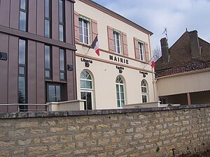
 Town hall (Mairie) of Farges-lès-Chalon |
||
Farges-lès-Chalon is a French municipality with 779 inhabitants (as of January 1 2017) in the department of Saone-et-Loire in the region of Bourgogne Franche-Comté . It belongs to the arrondissement Chalon-sur-Saône and is part of the canton Chalon-sur-Saône-1 (until 2015: canton Chalon-sur-Saône-Nord ).
geography
Farges-lès-Chalon is located about six kilometers north-northwest of Chalon-sur-Saône . Farges-lès-Chalon is surrounded by the neighboring communities of Fontaines in the north and west, Fragnes-La Loyère in the east and north-east, Champforgeuil in the south and south-east and Mellecey in the south-west.
Population development
| year | 1962 | 1968 | 1975 | 1982 | 1990 | 1999 | 2006 | 2013 |
|---|---|---|---|---|---|---|---|---|
| Residents | 318 | 305 | 361 | 433 | 531 | 622 | 719 | 708 |
| Source: Cassini and INSEE | ||||||||
Web links
Commons : Farges-lès-Chalon - Collection of images, videos and audio files
