Charnay-lès-Chalon
| Charnay-lès-Chalon | ||
|---|---|---|
|
|
||
| region | Bourgogne-Franche-Comté | |
| Department | Saône-et-Loire | |
| Arrondissement | Chalon-sur-Saône | |
| Canton | Gergy | |
| Community association | Saône Doubs Bresse | |
| Coordinates | 46 ° 56 ' N , 5 ° 6' E | |
| height | 172-188 m | |
| surface | 9.24 km 2 | |
| Residents | 187 (January 1, 2017) | |
| Population density | 20 inhabitants / km 2 | |
| Post Code | 71350 | |
| INSEE code | 71104 | |
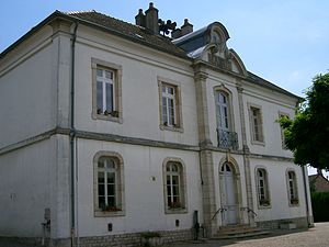
 Town hall (Mairie) of Charnay-lès-Chalon |
||
Charnay-lès-Chalon is a French municipality with 187 inhabitants (as of January 1 2017) in the department of Saone-et-Loire in the region of Bourgogne Franche-Comté (before 2016 Bourgogne ). It belongs to the arrondissement Chalon-sur-Saône and is part of the canton Gergy (until 2015 Verdun-sur-le-Doubs ).
geography
Charnay-lès-Chalon is located about 29 kilometers northeast of Chalon-sur-Saône between Saône and Doubs . Charnay-lès-Chalon is surrounded by the neighboring communities of Écuelles in the north, Chivres in the north and north-east, Mont-lès-Seurre in the north-east, Pontoux in the east and south-east, Saunières in the south and Bragny-sur-Saône in the west and south-west.
Population development
| year | 1962 | 1968 | 1975 | 1982 | 1990 | 1999 | 2006 | 2011 | 2016 |
|---|---|---|---|---|---|---|---|---|---|
| Residents | 249 | 231 | 211 | 181 | 173 | 178 | 178 | 180 | 184 |
| Sources: Cassini and INSEE | |||||||||
Attractions
- Saint-Grégoire-le-Grand church
- Cemetery cross, Monument historique since 1930
Web links
Commons : Charnay-lès-Chalon - Collection of images, videos and audio files

