
Jambles
| Jambles | ||
|---|---|---|
|
||
| region | Bourgogne-Franche-Comté | |
| Department | Saône-et-Loire | |
| Arrondissement | Chalon-sur-Saône | |
| Canton | Givry | |
| Community association | Le Grand Chalon | |
| Coordinates | 46 ° 46 ′ N , 4 ° 42 ′ E | |
| height | 234-495 m | |
| surface | 8.25 km 2 | |
| Residents | 490 (January 1, 2017) | |
| Population density | 59 inhabitants / km 2 | |
| Post Code | 71640 | |
| INSEE code | 71241 | |
| Website | http://www.jambles.fr/ | |
_mairie.JPG) Town Hall (Mairie) of Jambles |
||

Jambles is a municipality with 490 inhabitants (as of January 1 2017) in Saône-et-Loire in the region of Bourgogne Franche-Comté in eastern France . The inhabitants are called Jamblois .
geography
Jambles is located about 17 kilometers west-southwest of Chalon-sur-Saône . Neighboring municipalities of Jambles are Châtel-Moron in the north and north-west, Barizey and Saint-Denis-de-Vaux in the north, Givry in the east, Saint-Désert in the south and Sainte-Hélène in the west and south-west.
Population development
| year | 1962 | 1968 | 1975 | 1982 | 1990 | 1999 | 2006 | 2013 |
| Residents | 383 | 382 | 350 | 427 | 432 | 475 | 491 | 494 |
| Source: Cassini and INSEE | ||||||||
Attractions
- Saint-Bénigne church from the 12th century
- Charnailles Castle from the 15th century
- Windmill
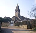
Saint-Bénigne church

Charnailles Castle


source
- ↑ Commune de Jambles (71241) - COG Insee. Retrieved April 13, 2018 (French).
Web links
Commons : Jambles - collection of images, videos and audio files