
Chaudenay (Saône-et-Loire)
| Chaudenay | ||
|---|---|---|

|
|
|
| region | Bourgogne-Franche-Comté | |
| Department | Saône-et-Loire | |
| Arrondissement | Chalon-sur-Saône | |
| Canton | Chagny | |
| Community association | Beaune Cote et Sud | |
| Coordinates | 46 ° 55 ' N , 4 ° 47' E | |
| height | 196-230 m | |
| surface | 8.17 km 2 | |
| Residents | 1,112 (January 1, 2017) | |
| Population density | 136 inhabitants / km 2 | |
| Post Code | 71150 | |
| INSEE code | 71119 | |
| Website | http://www.chaudenay.fr/ | |
 Town Hall (Mairie) of Chaudenay |
||

Chaudenay is a French commune with 1,112 inhabitants (as of January 1 2017) in Saône-et-Loire in the Région Bourgogne Franche-Comté . The municipality belongs to the arrondissement of Chalon-sur-Saône and the canton of Chagny . The inhabitants are called Chaudenaysia .
geography
Chaudenay is on the Dheune . Numerous types of wine are grown here in the Bourgogne wine-growing region , which is also delimited under the place name Gamay de Chaudenay . Chaudenay is surrounded by the neighboring communities of Ébaty in the north, Corcelles-les-Arts in the north and northeast, Demigny in the east, Chagny in the south and west and Corpeau in the northwest.
Population development
| year | 1962 | 1968 | 1975 | 1982 | 1990 | 1999 | 2006 | 2013 |
| Residents | 726 | 742 | 710 | 781 | 802 | 830 | 946 | 1,087 |
| Source: Cassini and INSEE | ||||||||
Attractions
- Saint-Véran church from the 13th century
- Manor house from the 12th century
- Mimande Castle from the 18th century
- Saint-Éloi bridge

Saint-Véran church

Mimande Castle
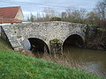
Saint-Éloi bridge


Web links
Commons : Chaudenay - collection of images, videos and audio files