
La Chapelle-de-Bragny
| La Chapelle-de-Bragny | ||
|---|---|---|
|
||
| region | Bourgogne-Franche-Comté | |
| Department | Saône-et-Loire | |
| Arrondissement | Chalon-sur-Saône | |
| Canton | Tournus | |
| Community association | Entre Saône et Grosne | |
| Coordinates | 46 ° 38 ′ N , 4 ° 46 ′ E | |
| height | 183-233 m | |
| surface | 15.87 km 2 | |
| Residents | 248 (January 1, 2017) | |
| Population density | 16 inhabitants / km 2 | |
| Post Code | 71240 | |
| INSEE code | 71089 | |
| Website | http://www.lachapelledebragny.fr/ | |

La Chapelle-de-Bragny is a French municipality with 248 inhabitants (at January 1, 2017) in the department of Saone-et-Loire in the region of Bourgogne Franche-Comté (before 2016 Bourgogne ). It belongs to the arrondissement Chalon-sur-Saône and is part of the canton of Tournus (until 2015 Sennecey-le-Grand ).
geography
La Chapelle-de-Bragny is about 16 kilometers south-southwest of Chalon-sur-Saône . La Chapelle-de-Bragny is surrounded by the neighboring communities of Messey-sur-Grosne in the north and west, Lalheue in the north-east, Nanton in the east, Étrigny in the south and south-east, Bresse-sur-Grosne in the south and south-west, Sercy in the south-west and Santilly in the west and southwest.
Population development
| year | 1962 | 1968 | 1975 | 1982 | 1990 | 1999 | 2006 | 2011 | 2016 |
| Residents | 180 | 189 | 168 | 204 | 203 | 226 | 240 | 240 | 253 |
| Source: Cassini and INSEE | |||||||||
Attractions
- Notre-Dame-de-l'Assomption church
- La Chapelle-de-Bragny castle, historic monument since 1974

Notre-Dame-de-l'Assomption church
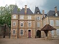
La Chapelle-de-Bragny castle

