
Saint-Bérain-sur-Dheune
| Saint-Bérain-sur-Dheune | ||
|---|---|---|
.svg)
|
|
|
| region | Bourgogne-Franche-Comté | |
| Department | Saône-et-Loire | |
| Arrondissement | Chalon-sur-Saône | |
| Canton | Chagny | |
| Community association | Le Grand Chalon | |
| Coordinates | 46 ° 50 ′ N , 4 ° 36 ′ E | |
| height | 234-480 m | |
| surface | 12.67 km 2 | |
| Residents | 553 (January 1, 2017) | |
| Population density | 44 inhabitants / km 2 | |
| Post Code | 71510 | |
| INSEE code | 71391 | |

Saint-Bérain-sur-Dheune is a French municipality with 553 inhabitants (at January 1, 2017) in Saône-et-Loire in the Région Bourgogne Franche-Comté (before 2016 Bourgogne ). The municipality belongs to the arrondissement Chalon-sur-Saône and the canton Chagny (until 2015 Givry ).
geography
Saint-Bérain-sur-Dheune is located on the Dheune . Numerous types of wine are grown here in the Bourgogne wine region . Saint-Bérain-sur-Dheune is surrounded by the neighboring communities of Saint-Jean-de-Trézy in the north and north-west, Saint-Léger-sur-Dheune in the north and north-east, Saint-Mard-de-Vaux in the east, and Châtel-Moron in the South and Southeast, Morey in the South and Southwest and Perreuil in the West and Southwest.
Population development
| year | 1962 | 1968 | 1975 | 1982 | 1990 | 1999 | 2006 | 2013 |
| Residents | 680 | 623 | 542 | 453 | 446 | 499 | 557 | 564 |
| Source: Cassini and INSEE | ||||||||
Attractions
- Saint-Bénigne church
- Cemetery chapel, Monument historique
- La Motte-sur-Dheune castle
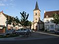
Saint-Bénigne church

Cemetery chapel

