
Boyer (Saône-et-Loire)
| Boyer | ||
|---|---|---|
|
||
| region | Bourgogne-Franche-Comté | |
| Department | Saône-et-Loire | |
| Arrondissement | Chalon-sur-Saône | |
| Canton | Tournus | |
| Community association | Entre Saône et Grosne | |
| Coordinates | 46 ° 36 ' N , 4 ° 53' E | |
| height | 169-305 m | |
| surface | 16.93 km 2 | |
| Residents | 719 (January 1, 2017) | |
| Population density | 42 inhabitants / km 2 | |
| Post Code | 71700 | |
| INSEE code | 71052 | |
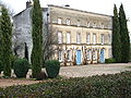
 City Hall (Mairie) by Boyer |
||

Boyer is a French municipality with 719 inhabitants (as of January 1 2017) in the department of Saone-et-Loire in the region of Bourgogne Franche-Comté ; it belongs to the arrondissement Chalon-sur-Saône and is part of the canton of Tournus (until 2015: canton of Sennecey-le-Grand ). The inhabitants are called boétrats .
geography
Boyer is located about 21 kilometers south of Chalon-sur-Saône on the Saône . Boyer is surrounded by the neighboring communities of Sennecey-le-Grand in the north, Gigny-sur-Saône and Ormes in the northeast, Simandre in the east, Tournus in the south, Vers in the southwest and Jugy in the west.
Population development
| year | 1936 | 1954 | 1962 | 1968 | 1975 | 1982 | 1990 | 1999 | 2006 | 2013 |
| Residents | 811 | 750 | 760 | 704 | 673 | 646 | 655 | 639 | 671 | 691 |
| Source: Cassini and INSEE | ||||||||||
Attractions
- Menhir La Pierre-Fiche on the Saône , Monument historique since 1923
- Notre-Dame monastery in Venière
- Saint-Loup church
- L'Arvolot castle from the 18th century
- Pymont Castle
- Venière Castle

Saint-Loup church

Notre-Dame monastery
Arvolot Castle

Venière Castle
_Eglise.JPG)

_-_1.JPG)
_-_1.JPG)
Personalities
- Loup de Chalon-sur-Saône (6th century; † around 610), Bishop of Chalon-sur-Saône (601–602), saint of the Roman Catholic Church, born here
Web links
Commons : Boyer - collection of images, videos and audio files