Saint-Léger-sur-Dheune
| Saint-Léger-sur-Dheune | ||
|---|---|---|

|
|
|
| region | Bourgogne-Franche-Comté | |
| Department | Saône-et-Loire | |
| Arrondissement | Chalon-sur-Saône | |
| Canton | Chagny | |
| Community association | Le Grand Chalon | |
| Coordinates | 46 ° 51 ' N , 4 ° 38' E | |
| height | 227-477 m | |
| surface | 12.16 km 2 | |
| Residents | 1,567 (January 1, 2017) | |
| Population density | 129 inhabitants / km 2 | |
| Post Code | 71510 | |
| INSEE code | 71442 | |
| Website | www.stlegerdheune.fr | |
 Mairie Saint-Léger-sur-Dheune |
||
Saint-Léger-sur-Dheune is a French commune with 1,567 inhabitants (at January 1, 2017) in Saône-et-Loire in the Région Bourgogne Franche-Comté .
geography
Saint-Léger-sur-Dheune is located in the valley of the river Dheune and on the parallel Canal du Center .
history
In the 19th century, with the construction of the Canal du Center , Saint-Léger-sur-Dheune developed from an agricultural community into a trading port. This made it possible to market local products (e.g. coal and tiles) from the first flooding of the canal in 1793. A railway connection was added from 1867. Today the region's natural resources no longer play a role and the canal is primarily used for recreational shipping.
Population development
| year | 1768 | 1836 | 1891 | 1962 | 1968 | 1975 | 1982 | 1990 | 1999 | 2009 |
| Residents | 915 | 1755 | 2395 | 1414 | 1439 | 1433 | 1459 | 1321 | 1461 | 1547 |
Attractions
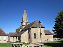
The Romanesque church of Saint-Léger from the 12th century with an octagonal bell tower from the 15th century is worth seeing. It was enlarged in the middle of the 19th century and restored at the end of the 20th century.
Partner municipality
- Profondeville , Belgium
Economy and Infrastructure
Until the 19th century, Saint-Léger-sur-Dheune was dominated by agriculture. With the canal and rail link, local products were marketed, such as B. Coal.

