Châtenoy-le-Royal
| Châtenoy-le-Royal | ||
|---|---|---|
|
|
||
| region | Bourgogne-Franche-Comté | |
| Department | Saône-et-Loire | |
| Arrondissement | Chalon-sur-Saône | |
| Canton | Chalon-sur-Saône-3 | |
| Community association | Le Grand Chalon | |
| Coordinates | 46 ° 48 ' N , 4 ° 49' E | |
| height | 172-206 m | |
| surface | 12.55 km 2 | |
| Residents | 6,177 (January 1, 2017) | |
| Population density | 492 inhabitants / km 2 | |
| Post Code | 71880 | |
| INSEE code | 71118 | |
| Website | http://www.chatenoyleroyal.fr/ | |
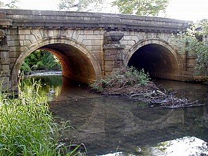
 Bridge over the Talie |
||
Châtenoy-le-Royal is a French municipality with 6177 inhabitants (as of January 1 2017) in the department of Saone-et-Loire in the region of Bourgogne Franche-Comté . It belongs to the arrondissement Chalon-sur-Saône and the canton Chalon-sur-Saône-3 (until 2015: canton Chalon-sur-Saône-Ouest ). The inhabitants are called Chatenoyens .
geography
Châtenoy-le-Royal lies on the river Talie . Châtenoy-le-Royal is surrounded by the neighboring communities of Champforgeuil in the northeast, Chalon-sur-Saône in the east, Saint-Rémy in the southeast, Dracy-le-Fort and Givry in the west and Mellecey in the northwest.
The A6 autoroute runs through the municipality .
Population development
| year | 1962 | 1968 | 1975 | 1982 | 1990 | 1999 | 2006 | 2011 |
| Residents | 2370 | 3779 | 4909 | 5767 | 5689 | 5938 | 5977 | 5991 |
Attractions
- Chapel of the Château de Cruzille from the 16th century, monument historique since 2001
- Bridge over the Thalie from 1766, monument historique since 1931
- 19th century wash house
Personalities
- Félix Gaudin (1851–1930), glass painter
- Marguerite Verdat (1893–1971), writer
- Marcelle Verdat (1896–1972), writer
Community partnerships
- Benigamin , Valencia, Spain
Web link
Commons : Châtenoy-le-Royal - Collection of images, videos and audio files
