
Saint-Maurice-des-Champs
| Saint-Maurice-des-Champs | ||
|---|---|---|
|
||
| region | Bourgogne-Franche-Comté | |
| Department | Saône-et-Loire | |
| Arrondissement | Chalon-sur-Saône | |
| Canton | Givry | |
| Community association | Sud Cote Chalonnaise | |
| Coordinates | 46 ° 38 ′ N , 4 ° 37 ′ E | |
| height | 275-408 m | |
| surface | 5.83 km 2 | |
| Residents | 62 (January 1, 2017) | |
| Population density | 11 inhabitants / km 2 | |
| Post Code | 71460 | |
| INSEE code | 71461 | |
| Website | http://www.saintmauricedeschamps.fr/le-village | |

Saint-Maurice-des-Champs is a French commune with a population of 62 (as at 1st January 2017) in the department of Saone-et-Loire in the region of Bourgogne Franche-Comté (before 2016 Bourgogne ). The municipality belongs to the arrondissement Chalon-sur-Saône and the canton Givry (until 2015: Buxy ). The inhabitants are called Campimauriciens .
location
Saint-Maurice-des-Champs is located about 24 kilometers southwest of Chalon-sur-Saône . Saint-Maurice-des-Champs is surrounded by the neighboring communities of Saint-Martin-du-Tartre in the north, Culles-les-Roches in the north-east, Saint-Gengoux-le-National in the east and south-east, Burnand in the south and Vaux-en- Pré in the west.
population
| year | 1962 | 1968 | 1975 | 1982 | 1990 | 1999 | 2006 | 2011 | 2016 |
|---|---|---|---|---|---|---|---|---|---|
| population | 87 | 95 | 68 | 81 | 66 | 52 | 58 | 63 | 63 |
| Source: Cassini and INSEE | |||||||||
Attractions
- Saint-Maurice church from the 12th century, monument historique
- La Rochette Castle
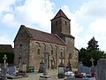
Saint-Maurice Church

La Rochette Castle

_-_1.JPG)
Web links
Commons : Saint-Maurice-des-Champs - Collection of images, videos and audio files