
Germagny
| Germagny | ||
|---|---|---|
|
||
| region | Bourgogne-Franche-Comté | |
| Department | Saône-et-Loire | |
| Arrondissement | Chalon-sur-Saône | |
| Canton | Givry | |
| Community association | Sud Cote Chalonnaise | |
| Coordinates | 46 ° 40 ′ N , 4 ° 36 ′ E | |
| height | 245-358 m | |
| surface | 3.47 km 2 | |
| Residents | 202 (January 1, 2017) | |
| Population density | 58 inhabitants / km 2 | |
| Post Code | 71460 | |
| INSEE code | 71216 | |

Germagny is a French municipality with 202 inhabitants (as of January 1 2017) in the department of Saone-et-Loire in the region of Bourgogne Franche-Comté . It belongs to the arrondissement of Chalon-sur-Saône and is part of the canton Givry (until 2015: canton Buxy ). The inhabitants are called Germanéens .
geography
Germagny is located about 22 kilometers southwest of Chalon-sur-Saône . Germagny is surrounded by the neighboring communities of Savianges in the north, Fley in the east and northeast, Bissy-sur-Fley in the east, Saint-Martin-du-Tartre in the south and southeast and Le Puley in the west.
Population development
| year | 1962 | 1968 | 1975 | 1982 | 1990 | 1999 | 2006 | 2013 |
|---|---|---|---|---|---|---|---|---|
| Residents | 159 | 148 | 186 | 174 | 166 | 156 | 159 | 210 |
| Source: Cassini and INSEE | ||||||||
Attractions
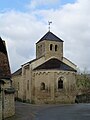
- Notre-Dame-de-l'Assomption church from the 12th century,
- Old Mill
church

Old Mill


Web links
Commons : Germagny - collection of images, videos and audio files