
Savianges
| Savianges | ||
|---|---|---|
|
||
| region | Bourgogne-Franche-Comté | |
| Department | Saône-et-Loire | |
| Arrondissement | Chalon-sur-Saône | |
| Canton | Givry | |
| Community association | Sud Cote Chalonnaise | |
| Coordinates | 46 ° 42 ′ N , 4 ° 36 ′ E | |
| height | 252-419 m | |
| surface | 6.56 km 2 | |
| Residents | 74 (January 1, 2017) | |
| Population density | 11 inhabitants / km 2 | |
| Post Code | 71460 | |
| INSEE code | 71505 | |
.JPG) Town Hall (Mairie) of Savianges |
||

Savianges is a French commune with a population of 74 (as at 1st January 2017) in the department of Saone-et-Loire in the region of Bourgogne Franche-Comté (before 2016 Bourgogne ). The municipality belongs to the arrondissement Chalon-sur-Saône and the canton Givry (until 2015: Buxy ).
location
Savianges is about 25 kilometers west-southwest of Chalon-sur-Saône . Savianges is surrounded by the neighboring communities of Saint-Privé in the north and west, Cersot in the northeast, Fley in the east and southeast, Germagny in the south and Le Puley in the southwest.
population
| year | 1962 | 1968 | 1975 | 1982 | 1990 | 1999 | 2006 | 2011 | 2016 |
|---|---|---|---|---|---|---|---|---|---|
| population | 67 | 66 | 53 | 54 | 70 | 80 | 66 | 77 | 75 |
| Source: Cassini and INSEE | |||||||||
Attractions
- Saint-Révérien church from the 15th century, monument historique since 1982
- old rectory, originally from the 13th century, alterations from the 16th century
- Savianges Castle
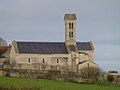
Saint-Révérien church

old rectory

Savianges Castle


Web links
Commons : Savianges - collection of images, videos and audio files