
Hussigny-Godbrange
| Hussigny-Godbrange | ||
|---|---|---|

|
|
|
| region | Grand Est | |
| Department | Meurthe-et-Moselle | |
| Arrondissement | Briey | |
| Canton | Villerupt | |
| Community association | Longwy | |
| Coordinates | 49 ° 30 ' N , 5 ° 52' E | |
| height | 275-445 m | |
| surface | 15.37 km 2 | |
| Residents | 3,571 (January 1, 2017) | |
| Population density | 232 inhabitants / km 2 | |
| Post Code | 54590 | |
| INSEE code | 54270 | |
| Website | www.mairiehussignygodbrange.fr | |
 Mairie of the parish |
||

Hussigny-Godbrange ( German Hussingen-Godhaben , Luxembourgish Héiséng / Héisséng-Gueberéng ) is a French commune with 3571 inhabitants (as of January 1, 2017) in the Meurthe-et-Moselle department in the Grand Est region (until 2015 Lorraine ). It belongs to the canton of Villerupt (until 2015: canton of Herserange ) in the arrondissement of Briey . The inhabitants are known as the Hussingeois .
geography
The municipality of Hussigny-Godbrange is on the border with Luxembourg , across from Differdange .
history
The place was first mentioned in 1249 as Husingen .
Before that it belonged to Luxembourg as a fiefdom (until 1602).
Hussigny-Godbrange was a center of Italian immigration in Lorraine at the end of the 19th century. In the Italian part of Hussigny, which was also called “la Basse-Italie”, romagnol , an Italian dialect from Romagna , was spoken until the end of the 1950s .
To the east of Hussigny-Godbrange was the triangle between France , the German Empire and Luxembourg from 1871 to 1920 .
Population development
| year | 1962 | 1968 | 1975 | 1982 | 1990 | 1999 | 2007 | 2016 |
| Residents | 2942 | 3499 | 3208 | 2871 | 2827 | 3076 | 3243 | 3511 |
Attractions
- Nativité-de-la-Vierge church
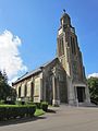
Church of the Birth of Our Lady ( Église de la Nativité-de-la-Vierge )

Fallen memorial


Personalities
- Evelyne Marie France Neff (* 1941), Franco-German politician; the Federal Cross of Merit was born in Hussigny