
Ibăneşti (Mureş)
|
Ibăneşti Libánfalva |
|||||
|
|||||
| Basic data | |||||
|---|---|---|---|---|---|
| State : |
|
||||
| Historical region : | Transylvania | ||||
| Circle : | Mureș | ||||
| Coordinates : | 46 ° 46 ' N , 24 ° 56' E | ||||
| Time zone : | EET ( UTC +2) | ||||
| Height : | 469 m | ||||
| Area : | 313.15 km² | ||||
| Residents : | 4,357 (October 20, 2011) | ||||
| Population density : | 14 inhabitants per km² | ||||
| Postal code : | 547325 | ||||
| Telephone code : | (+40) 02 65 | ||||
| License plate : | MS | ||||
| Structure and administration (as of 2016) | |||||
| Community type : | local community | ||||
| Structure : | Ibăneşti, Blidireasa , Brădețelu , Dulcea , Ibăneşti-Pădure , Lăpuşna , Pârâu Mare , Tireu , Tisieu , Zimți | ||||
| Mayor : | Vasile-Dumitru Dan ( PSD ) | ||||
| Postal address : | Str. Principală, no. 708 loc. Ibăneşti, jud. Mureș, RO-547325 |
||||
| Website : | |||||
| Others | |||||
| City Festival : | annually in August: Festivalul Văii Gurghiului | ||||


Ibăneşti [ ˈibəneʃtʲ ] ( Hungarian Libánfalva ) is a municipality in Mureş County , in the Transylvania region in Romania .
Ibăneşti is the Romanian partner municipality of the European Charter - Villages of Europe , a group of rural municipalities from all 28 EU countries.
Geographical location

The community Ibăneşti is located in the western foothills of the Gurghiu Mountains (Munții Gurghiu) east of the Reener Ländchen , in the east of the Mureş district. On the Gurghiu, a left tributary of the Mureş (Mieresch) and on the county road (drum județean) DJ 153C, the place Ibăneşti is 15 kilometers east of the city of Reghin (Saxon Rain) and about 50 kilometers northeast of the district capital Târgu Mureş (Neumarkt am Mieresch) removed.
history
The place Ibăneşti was first mentioned in 1453. According to G. Téglás and M. Roska , archaeological finds were made on the area called Pietroasa by the locals , suggesting that the region was settled in early history . Finds from Roman times are also noted.
In the Kingdom of Hungary , today's municipality belonged to the Régen alsó (Lower Rain) district in Maros-Torda County , then to the historical Mureș District and, from 1950, today's Mureș District.
population
The population of Ibăneşti Municipality developed as follows:
| census | Ethnic composition | ||||
|---|---|---|---|---|---|
| year | population | Romanians | Hungary | German | other |
| 1850 | 1,446 | 1,390 | - | - | 56 |
| 1900 | 2,966 | 2,830 | 60 | 63 | 13 |
| 1966 | 5,986 | 5,736 | 237 | 1 | 12 |
| 2002 | 4,511 | 4,495 | 15th | 1 | - |
| 2011 | 4,357 | 4,266 | 8th | 2 | 81 |
Since 1850 the highest number of inhabitants, that of the Romanians and that of the Magyars, was registered in the area of today's municipality in 1966. The highest number of Romanian Germans in 1900 and that of Roma (80) was determined in 1930.
The main occupation of the population is livestock and forestry.
Attractions
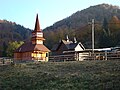
- In the incorporated village of Lăpușna (Hungarian Laposnyatelep ), the wooden church “Sf. Nicolae ”built in 1779 and the small hunting lodge built between 1900 and 1930 are listed as historical monuments.
- The community is also the starting point for the Gurghiuer Mountains.

Wooden church in Lăpușna

Hunting lodge in Lăpușna
Wooden church in Ibăneşti-Pădure
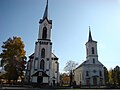
Orthodox and Greek Catholic Church in Ibăneşti

.jpg)


Web links
- Ibăneşti at ghidulprimariilor.ro
- Entry on Ibăneşti at the European Charter - Villages of Europe (English)
Individual evidence
- ↑ 2011 census in Romania ( MS Excel ; 1.3 MB)
- ↑ Heinz Heltmann, Gustav Servatius (Ed.): Travel Guide Siebenbürgen . Kraft, Würzburg 1993, ISBN 3-8083-2019-2 , p. 517 .
- ^ Institute Of Archeology - Ibănești , accessed October 11, 2018 (Romanian).
- ↑ Censuses 1850–2002, last updated November 2, 2008 (PDF; 1 MB; Hungarian)
- ↑ List of historical monuments of the Romanian Ministry of Culture, updated 2010 (PDF; 7.10 MB)
Acățari | Adămuș | Albeşti | Aluniș | Apold | Ațintiș | Băgaciu | Bahnea | Băla | Bălăușeri | Band | Batoș | Beica de Jos | Bereni | Bichiș | Bogata | Brâncoveneşti | Breaza | Ceuașu de Câmpie | Chețani | Chiheru de Jos | Coroisânmărtin | Corunca | Cozma | Crăciuneşti | Crăiești | Cristești | Cucerdea | Cuci | Daneș | Deda | Hermit | Ernei | Fântânele | Fărăgău | Gălești | Găneşti | Gheorghe Doja | Ghindari | Glodeni | Gorneşti | Grebenișu de Câmpie | Gurghiu | Hodac | Hodoșa | Ibăneşti | Iclănzel | Ideciu de Jos | Livezeni | Lunca | Lunca Bradului | Măgherani | Mica | Miheșu de Câmpie | Nadeș | Neaua | Ogra | Pănet | Papiu Ilarian | Păsăreni | Petelea | Pogăceaua | Râciu | Răstolița | Rușii-Munți | Sâncraiu de Mureș | Sângeorgiu de Mureș | Singer | Sânpaul | Sânpetru de Câmpie | Sântana de Mureș | Saschiz | Sărățeni | Șăulia | Șincai | Solovăstru | Stânceni | Suplac | Suseni | Tăureni | Valea Largă | Vânători | Vărgata | Vătava | Vețca | Viișoara | Voivodeni | Zagăr | Zau de Câmpie
![]() Bienvenida •
Bièvre •
Bucine •
Cashel •
Cissé •
Desborough •
Ash •
Hepstedt •
Holmegaard •
Ibanesti •
Kandava •
Kannus •
Kolindros •
Lassee •
Pano Lefkara •
Medzev •
Moravče •
Nadur •
Nagycenk •
Ockelbo •
Põlva •
Samuel •
Sliwo poles •
Stary Poddvorov •
Strzyżów •
Tisno •
Troisvierges •
Žagarė
Bienvenida •
Bièvre •
Bucine •
Cashel •
Cissé •
Desborough •
Ash •
Hepstedt •
Holmegaard •
Ibanesti •
Kandava •
Kannus •
Kolindros •
Lassee •
Pano Lefkara •
Medzev •
Moravče •
Nadur •
Nagycenk •
Ockelbo •
Põlva •
Samuel •
Sliwo poles •
Stary Poddvorov •
Strzyżów •
Tisno •
Troisvierges •
Žagarė![]()
![]()
![]()
![]()
![]()
![]()
![]()
![]()
![]()
![]()
![]()
![]()
![]()
![]()
![]()
![]()
![]()
![]()
![]()
![]()
![]()
![]()
![]()
![]()
![]()
![]()
![]()