Königstein (Saxon Switzerland)
| coat of arms | Germany map | |
|---|---|---|

|
Coordinates: 50 ° 55 ' N , 14 ° 4' E |
|
| Basic data | ||
| State : | Saxony | |
| County : | Saxon Switzerland-Eastern Ore Mountains | |
| Management Community : | Koenigstein / Saxon. Schw. | |
| Height : | 212 m above sea level NHN | |
| Area : | 27.04 km 2 | |
| Residents: | 2087 (Dec. 31, 2019) | |
| Population density : | 77 inhabitants per km 2 | |
| Postal code : | 01824 | |
| Area code : | 035021 | |
| License plate : | PIR, DW, FTL, SEB | |
| Community key : | 14 6 28 210 | |
| City structure: | 3 districts | |
City administration address : |
Goethestr. 7 01824 Königstein (Saxon Switzerland) |
|
| Website : | ||
| Mayor : | Tobias Kummer ( CDU ) | |
| Location of the town of Königstein (Saxon Switzerland) in the Saxon Switzerland-Eastern Ore Mountains district | ||
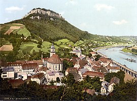
Königstein (Saxon Switzerland) is a city in south-east Saxony on the Elbe . The town, which belongs to the district of Saxon Switzerland-Eastern Ore Mountains , is the seat of the Königstein / Sächs administrative community. Schw. Königstein Fortress is located on the hill of the same name .
geography
Geographical location
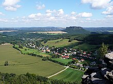
The town of Königstein lies between Pirna and the Czech border at the mouth of the Biela and Elbe in the south of the Saxon Switzerland-Eastern Ore Mountains district in Germany . Here in the middle of the Elbe Sandstone Mountains you can observe a variety of landscape formations. The fortress on the Königstein stands on a sandstone rock above the Elbe valley. Like everywhere else in the region, the valleys washed out by streams and rivers create bizarre hillside and rocky landscapes. The largest moor in Saxon Switzerland , located near Leupoldishain, fell victim to drainage in 1870, but can still be identified on the basis of typical residual vegetation.
In addition to their geological attractiveness, the Nikolsdorf walls are a popular climbing area . In the local area of Pfaffendorf , adjacent to Pfaffenstein, there is one of the landmarks of Saxon Switzerland, the 35 m high needle of the Barbarine , a geological natural monument that was first climbed in 1905. Numerous finds document the settlement since the Bronze Age .
Local division
According to the Saxon municipal code, Königstein only consists of the districts of Königstein, Pfaffendorf and Leupoldishain . Ebenheit , Elbhäuser , Halbestadt and Hütten are not formally districts, but they are referred to as districts because of a certain delimitation, due to their location clearly separated from Königstein and their history.
Flatness
Flatness, a forest hoof village , lies at 246 m above sea level. NN on the opposite side of the Elbe on an equally designated geomorphological unit of area below the Lilienstein . Already mentioned in 1489, the former settlers were probably the Fron subject peasants of the formerly settled on the hill castle. Today there are still two living and stable dwellings from the years 1747 and 1824, as can still be seen from the entrance stones.
Halbestadt

Halbestadt, also located on the right bank of the Elbe, was built around a Vorwerk belonging to the Königstein monastery in the 15th century . Here, on the so-called Napoleon climb to Lilienstein from the Wars of Liberation, there is still a typical half-timbered house for the region . The city of Königstein bought the surrounding fertile land in 1550. In the course of the Elbe regulations from 1864 to 1865, a small river port was created . An Elbe ferry runs between Halbestadt and the opposite city center.
Huts
The district located in the Bielatal below the Königstein fortress was first mentioned in 1445 as a hut settlement. The name refers to several iron hammers (middle and lower realm hammer, griffin hammer) in which iron was smelted . This was contained in small quantities as red iron stone in the sandstone itself, but the majority was transported from the iron ore mines around Berggießhübel to the Biela by cart . A reconstructed medieval blast furnace can be viewed in Brausenstein in the upper Bielatal . In this context, the region also speaks of Pirnisch iron or Pirna iron casting . From one of the hammer mills a paper mill emerged in the 16th century , which later developed into a respected paper mill under Hugo von Hoesch . The paper produced here is by no means ordinary. Banknote paper has been produced here since the First World War , and later also document paper for passports , identity cards and other border crossing documents . Today only banknotes, check , passport and security papers are produced, which are said to be extremely forgery-proof. Behind the paper mill was a cold water sanatorium, Bad Königsbrunn, which was operated until the early 20th century, and was a summer residence of the Saxon royal family. The king Steiner station from wrong in 1901 one of the first O-bus -lines in the world after huts. The line designed by Max Schiemann , the so-called Bielatalbahn , was shut down in 1904 and relocated to Wurzen .
Leupoldishain
That in the course of Ostkolonisation founded Waldhufendorf was first in 1379 as Leuchtholdshayn mentioned. The Nikolsdorf district , also a Waldhufendorf annexed in 1904 , was mentioned in the same year as Niklasdorff . Leupoldishain is located on the so-called Struppener flatness about 3 km west of Königstein. Agriculture was the dominant factor in the development of the village until recently. Some well-preserved farms still bear witness to this today . Tourism also developed after the First World War . In the 1950s, a natural stage with 1,100 seats was even built as part of the national construction project . Uranium mining , however, set a limit for the emerging tourism . In 1963, a uranium ore deposit explored by the SDAG Wismut was opened up in Leupoldishain . Around 18,000 t of uranium had been extracted from this by 1990. The natural stage was also sacrificed to mining. At times over 2,300 people worked in the Leupoldishain mine. The renovation of the mine, which was closed in 1990 (today WISMUT GmbH Niederlassung Königstein ) is almost complete underground, the surface renovation is expected to continue until 2020. Concrete plans for subsequent use for the 80 hectare main site are not yet available. Future commercial use or the establishment of tourist offers is favored.
Pfaffendorf
The 1437 first time as Pfaffindorff mentioned Waldhufendorf is located below the Pfaff stone in a flat for Biela back drop well. The name is derived from the former feudal lord , the priest of Königstein, to whom the residents had to make interest payments. A section of the so-called "Old Tetschener Straße" used to run through Pfaffendorf, a trade route that connected the Elbe Valley via Kleingießhübel with Děčín (Tetschen). The road overcame the difference in altitude between Königstein and Pfaffendorf with a few steep serpentines . The economy was shaped by agriculture into the 19th century. In 1755 there were eight estates in Pfaffendorf. In addition, the place has always been closely tied to Königstein economically. Numerous Pfaffendorf residents worked, for example, as sandstone crushers , boatmen or hammer mill workers in the Elbe and Biel valleys. The change from a farming village to a tourist resort took place after the First World War . In 1938, 193 guests stayed in the village. Today Pfaffendorf is a nationally recognized resort because of its proximity to the Pfaffenstein and the numerous well-preserved three-sided farms a popular excursion and holiday destination.
history
Königstein was first mentioned in a document in 1379. The place takes its name from the castle belonging to the Bohemian kings (1241 "in lapide regis" - [Latin] on the king's stone), who controlled the Elbe valley above Pirnas from here.
In 1901, the Bielatalbahn started operating between Königstein and Hütten as one of the first trolleybus operators in the world. However, operations were stopped again three years later.
At the beginning of the Nazi era , the Naturfreundehaus Halbestadt 13 was expropriated and converted into an early concentration camp , the Königstein satellite camp , in which 70 to 100 political Nazi opponents from Pirna and the surrounding areas were interned and mistreated. During the GDR era, the building was used as a youth hostel and was named Julius Fučíks . Towards the end of the Second World War from November 1944 to April 1945 which was central warehouse Koenigstein the Flossenburg concentration camp built: a camp on the donkey meadow with 1,000 prisoners, as well as a much larger camp in the forest Milchweg / Black trail between Thürmsdorf and Leupoldishain from which prisoners in District Weißig-Strand had to build underground tunnels for the Braunkohle Petrol AG ( BRABAG ) for gasoline production under the code name Schwalbe II , to which later prisoners of war and slave labor from other nations were added. Another detachment with 250 prisoners toiled in Porschdorf in the Polenz valley.
From 1961 to 1990 there was a significant mining of uranium by the SDAG Wismut .
In 2002 the city was badly hit by the Elbe flood of the century .
Development of the population
|
|
Compilation based on BLASCHKE 2003, German Academy of Sciences in Berlin 1957, Königstein Middle School 2004, SCHIFFNER 1840 and information from the State Statistical Office of Saxony, from 1991: as of December 31 of the respective year
Incorporations
- 1933: Hütten incorporated
- March 1, 1994: incorporation of Pfaffendorf
- January 1, 1999: incorporation of Leupoldishain
Memorials
- FIR memorial stone at Naturfreundehaus Halbestadt 13 for the Nazi opponent Fritz Gumpert , who was murdered here in 1933
- Memorial from 1977 next to the former district court on Pirnaer Strasse in memory of the prisoners who perished in the subcamps
- Memorial plaque at the gate of Königstein Fortress , which informed about the prisoner-of-war camp Oflag (officers' camp ) IV B and its liberation by the Red Army ; it was removed after 1990.
coat of arms
The coat of arms shows an upright, double-tailed Bohemian lion . It is reminiscent of the Bohemian history of Königstein, which only came into the hands of the Wettins in 1404 .
politics
City council
Since the municipal council election on May 26, 2019 , the 14 seats of the city council have been distributed among the individual groups as follows:
- Free voters Königstein (FW): 6 seats
- CDU : 4 seats
- LEFT : 1 seat
- NPD : 1 seat
- Citizens' Initiative Königstein (BiK): 2 seats
Administrative community
Since 2002, Königstein has been part of the Königstein / Sächs administrative community together with Gohrisch , Rathen , Rosenthal-Bielatal and Struppen . Schw.
mayor
In June 2015 Tobias Kummer was elected as the new mayor, he took office in August 2015.
Twin cities
- Königstein im Taunus in Hesse (since 1992)
- Königstein in the Upper Palatinate, Bavaria (since 1993)
- Trmice (Türmitz) in the Czech Republic (since 2002)
Representatives of the three Königsteiner communities meet annually for a "Dreikönigstreffen" working meeting in the Upper Palatinate.
economy
traffic
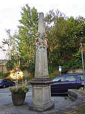
The federal highway 172 and the state highways S 168, S 170 and S 171 run through Königstein. The distance to the state capital Dresden is 31 km. Königstein has been connected to the railway network since May 1850 with a station on the Děčín – Dresden-Neustadt line . The S-Bahn line S1 of the S-Bahn Dresden runs along this . From Reissigerplatz, about five minutes' walk from the train station, bus routes lead to Hinterhermsdorf (via Bad Schandau ), the health resort Gohrisch , Pirna (via Struppen ) and to Rosenthal-Bielatal . The districts on the right bank of the Elbe, Ebenheit and Halbestadt, can be reached via a passenger ferry or on the road via Bad Schandau – Rathmannsdorf – Prossen. Both the bus routes and the ferry are operated by Regionalverkehr Sächsische Schweiz-Osterzgebirge GmbH. In Königstein there is a traffic-historically interesting post-distance column , the original parts of which are exhibited in the Museum Schloss Lauenstein (coat of arms) and in the newspaper museum Mainz (writing pad).
Established businesses
- WISMUT GmbH location Königstein (OT Leupoldishain): around 150 employees (May 2016), remediation of the legacy of uranium mining
- Giesecke & Devrient - Papierfabrik Louisenthal GmbH Königstein plant (OT Hütten): around 300 employees (2010), manufacture of banknote and security paper
- Kunststoffverarbeitung Bauer GmbH & Co. KG: The company based in the Leupoldishain industrial park has its core competence in thermoplastic and thermoset processing and employs around 60 people (2014),
- Landbäckerei Schmidt: The bakery located in the Leupoldishain industrial park (former location until 2014 in Cunnersdorf ) has a total of almost 30 branches in Saxon Switzerland and Dresden and employs around 220 people.
- Ehrlich Werkzeuge- und Gerätebau GmbH: The company based in the Leupoldishain industrial park settled in Königstein in 2013 (formerly in Pirna ). It primarily produces plastic parts for the vehicle industry and employs around 95 people (2013).
Culture, leisure, education, social affairs
Excursion destinations
- The four stones: Königstein is considered the city of four stones ( Königstein , Lilienstein , Pfaffenstein , Quirl ). The Königstein Fortress, which lies above the city, has been visited by around 500,000 people a year in recent years. From Lilienstein (416 m) you can see the striking Elbe loop, the "OMEGA". At the Pfaffenstein, the approximately 45 m high Barbarine rock needle and the observation tower on the mountain are worth seeing. The numerous caves (Diebshöhle, Sterlhöhlen, X1 / Kö13), mostly collapse caves, can be seen at the whorl.
- To the southwest of the city center are the Nikolsdorf walls with the extensive natural monument Labyrinth , a strongly jagged rock group south of the districts of Leupoldishain and Nikolsdorf, which are developed as a climbing area.
Museums
- Heimatstube Leupoldishain: The small Heimatstube informs about the development of the place with pictures, documents and objects.
- Koenigstein Fortress
freetime and sports
- Leupoldishain tennis and volleyball court
- Elbe leisure land
Public and social institutions
- Königstein primary school
- Königstein High School
Regular events
- In Königstein, as in other Upper Elbe towns, the “Schifferfastnacht”, a folk festival that ties in with the Elbe shipping tradition, takes place at the end of winter. The Schifferfastnachtsverein organizes a parade through the streets, during which the traditional Elbe ship models are carried through the city and the chapel serenades the houses of long-established shipowning families and other dignitaries. For the fun of the children, the “Fleckelmann” gives out “blows of order” with his gossip to disobedient (alcoholic) husbands and / or (quarrelsome) wives. The sutlers of the move give plenty of "thumb's breadth". The Schifferfastnacht ends with a hearty Schifferball.
- An independent carnival life began in Königstein from around 1953 and developed under the leadership of Horst Rülke (Königstein) and Gerd Neumann (Cunnersdorf). Carnival parades and ceremonial meetings were initially organized by the Elferrat . Later only ceremonial meetings took place, in which hidden criticism could be exercised during GDR times. As Königstein used to be nicknamed "Quirlequietsch", the Königstein carnival call is "Quietsch-Quirl-Oha".
Buildings
- The St. Mary's Church , which dates from the 15th century, was rebuilt several times after fires and decay, the last time in 1823. Its exterior is characterized by the Baroque , while elements of Classicism predominate inside .

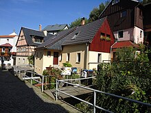
- Half-timbered house from 1587. It is a ground floor, two-tier half-timbered building with a two-layer block wreath with a wooden beam ceiling .
Personalities
sons and daughters of the town
- Fritz von Bose (1865–1945), pianist and music teacher
- Ernst Julius Otto (1804–1877), Kreuzkantor and conductor of the Dresdner Liedertafel
- Georg Schumann (1866–1952), musicologist and conductor, director of the Sing-Akademie zu Berlin from 1900 to 1952 , president of the Prussian Academy of the Arts
- Camillo Schumann (1872–1946), Georg's younger brother, composer and organist, honorary citizen of Bad Gottleuba
- Clemens Schumann (1876–1938), younger brother of Georg and Camillos, violinist in the Dresden Staatskapelle from 1900 to 1936
- Otto Panzner (1853–1921), sculptor
- Jo Hanns Rösler (1899–1966), writer
- Rudi Schiemann (1901–1970), cabaret artist
- Werner Neumann (1905–1991), Bach researcher
- Frank Ettrich (* 1958), sociologist
People connected to the city
- Friedrich Christoph zu Solms-Wildenfels (1712–1792), Electorate General of the Infantry, Commander of the Königstein Fortress
literature
- Königstein area, Saxon Switzerland (= values of the German homeland . Volume 1). 1st edition. Akademie Verlag, Berlin 1957.
- Königstein as the center of Saxon Switzerland and its surroundings in words and pictures . Königstein 1898 ( digitized version )
- Karlheinz Blaschke : The urban system from the 12th to the 19th century. Supplement to map B II 6 of the Atlas for the History and Regional Studies of Saxony (published by the Saxon Academy of Sciences and the State Surveying Office of Saxony). Leipzig / Dresden 2003.
- Siegmund Böhme: Family book of Königstein (Saxony) for the years 1625-1747. Plaidt: Cardamina 2011 (= Central German local family books 6).
- Friedrich August Brandner: City and Fortress Königstein. A historical compilation . Lauenstein / Pirna 1842 ( digitized version ).
- Middle School Königstein (ed.): 625 years of the city of Königstein. History and stories about Königstein. Koenigstein 2004.
- Albert Schiffner : Handbook of geography, statistics and topography of the Kingdom of Saxony. Volume 2. Leipzig 1840.
- Koenigstein . In: August Schumann : Complete State, Post and Newspaper Lexicon of Saxony. 5th volume. Schumann, Zwickau 1818, p. 3.
Web links
Individual evidence
- ↑ Population of the Free State of Saxony by municipalities on December 31, 2019 ( help on this ).
- ^ Main statute of the city
- ↑ Helmut Cedra: From tradition: 450 years of paper production in Königstein / Saxony . Self-published, 2010, ISBN 978-3-00-029779-3 (559 pages).
- ↑ a b Königstein (Saxon Switzerland) in the Digital Historical Directory of Saxony
- ↑ estimated based on house numbers from the 16th century, cf. BLASCHKE 2003
- ↑ calculated according to tax lists, cf. BLASCHKE 2003
- ↑ As of October 3, 1990
- ^ Hütten in the Digital Historical Directory of Saxony
- ↑ Municipalities 1994 and their changes since January 1, 1948 in the new federal states , Metzler-Poeschel publishing house, Stuttgart, 1995, ISBN 3-8246-0321-7 , publisher: Federal Statistical Office
- ↑ StBA: Changes in the municipalities in Germany, see 1999
- ↑ Results of the 2019 municipal council elections
- ↑ http://www.koenigstein-sachsen.de/de/Koenigstein/Begruessungswort-Buergermeister
- ↑ What is left of the uranium plant. In: Saxon newspaper. (Pirna edition), May 11, 2016.
- ↑ The head of the employment agency visits Papierfabrik Louisenthal GmbH, Königstein works. (No longer available online.) Federal Employment Agency Pirna, December 23, 2009, archived from the original on February 25, 2014 ; Retrieved February 19, 2014 . Info: The archive link was inserted automatically and has not yet been checked. Please check the original and archive link according to the instructions and then remove this notice.
- ↑ Company. Bauer GmbH & Co. KG, accessed on February 19, 2014 .
- ^ Sächsische Zeitung (Pirna edition) from 22./23. November 2014
- ↑ Pirna auto supplier moves to the country , Sächsische Zeitung (Pirna edition) from May 3, 2013


