
Khon Kaen (Province)
| Khon Kaen | |
|---|---|
| ขอนแก่น | |

|
|
| statistics | |
| Capital: | Khon Kaen |
| Telephone code: | 043 |
| Surface: |
10,886 km² 15. |
| Residents: |
1,896,000 (2011) 4. |
| Population density : | 162 E / km² 22. |
| ISO 3166-2 : | |
| Governor : | Sombat Triwatsuwan |
| map | |
  |
|
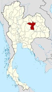
Khon Kaen ( Thai ขอนแก่น ) is a province ( Changwat ) in the northeast region of Thailand , the Isan . It is one of the most populous provinces in the country and plays a key role in trade, transport and education in northeast Thailand. The capital of the province of Khon Kaen is also called Khon Kaen .
geography
The province is located in the middle of the less fertile Khorat Plateau , about 360 kilometers northeast of the capital Bangkok .
| Neighboring provinces: | |
|---|---|
| north | Loei , Udon Thani and Nongbua Lamphu |
| east | Kalasin and Maha Sarakham |
| south | Buriram and Nakhon Ratchasima |
| west | Chaiyaphum and Phetchabun |
Important cities
Universities
- Khon Kaen University (coordinates: 16 ° 25 ′ 24.5 ″ N , 102 ° 48 ′ 33.5 ″ E )
- Technical University Rajamangala Isan Khon Kaen Campus (Coordinates: 16 ° 27 ′ 19.8 ″ N , 102 ° 49 ′ 43.7 ″ E )
climate
The climate is - as in the rest of Thailand - tropical - monsoonal . However, there are extreme differences between the hot season and winter. The hot season is really hot, more than 40 ° C in the shade is not uncommon. In winter, however, temperatures below 10 ° C can occur at night (in some places night frost is also possible), while in the rest of the country the thermometer practically never falls below 20 ° C. The land mass is already noticeable in the northeast and leads, so to speak, to a local “continental climate”.
|
Average monthly temperatures and rainfall for Khon Kaen
|
population
For many years up to the 14th century , the region was shaped by the Khmer . This is reflected in their own customs, in traditional music, special dances and also in numerous well-preserved buildings from the Khmer period. The Isan language is more closely related to the Lao language than the Thai language .
Economy and Importance


The area, like the rest of Isan, is relatively poor, the average income of the population is around 30% of what is earned in Bangkok. That is why there is a general, but only temporary, rural exodus : the people hire out in the richer areas and return to their homeland every now and then, especially to sow and harvest rice; But crowds - especially from the Bangkok region - also return to Songkran to celebrate in their homeland.
Regardless of this, Khon Kaen, next to Nakhon Ratchasima , is the most important administrative and commercial center of the northeast. Here is also the seat of a technical university, which was founded with German help, and a branch of the Thai-German Technical Institute . During the Vietnam War , the Americans expanded the area's infrastructure to use it as a deployment area. In particular, the so-called Friendship Highway (expressway of friendship, Thanon Mittraphap , today's National Road 2) was built, which also promotes economic development today, after it has been expanded in the meantime.
In 2011 the “Gross Provincial Product” ( gross domestic product ) at the current market price of the province was 155.272 billion Baht , that GPP per capita was 81,884 Baht.
In 2010 there were 1,368 factories in the province with total fixed assets of 71.206 billion baht. In 2011, the factories employed 47,648 people. In Khon Kaen, the utilized agricultural area is 4,369,043 rai, which is 64.2% of the total area of the province. In 2011 324,879 people were employed in the agricultural sector. The province has 142 hotels with 3,856 rooms.
The employment rate of over 15-year-olds is 98.45%, the unemployment rate 0.53%, the rate of seasonal workers is 1.02%.
Data
The table below shows the share of the economic sectors in the gross provincial product in percent.
| Industry | 2006 | 2007 | 2008 |
|---|---|---|---|
| Agriculture | 11.0 | 11.5 | 11.0 |
| Industry | 37.0 | 35.8 | 37.5 |
| Other | 52.0 | 52.7 | 51.5 |
All figures in%
The industry that made the largest contribution to the province's economic output in 2011 was manufacturing with 60.976 billion baht, followed by agriculture with 16.833 billion baht, education with 15.824 billion baht and wholesale and retail with 15.056 billion baht.
The province of Khon Kaen has a total of 1,049 wetlands with an area of 151.8 km², which are used more or less intensively for agriculture .
Dams
Ubol Ratana Dam - was originally called Phong Neep; forms the largest reservoir in the Isan and is surmounted by a tall, white Buddha statue (coordinates: 16 ° 45 ′ 49.3 ″ N , 102 ° 37 ′ 10.4 ″ E ). It is also a popular destination, especially to the stone beaches “Pattaya 2” (coordinates: 16 ° 38 ′ 14.8 ″ N , 102 ° 32 ′ 42.9 ″ E ) and “Bang Saen 2” (coordinates: 16 ° 44 ′ 21.4 " N , 102 ° 37 '44.7" O ).
traffic
Airport
Khon Kaen (code KKC).
history
The area was demonstrably already in the 4th millennium BC. Settled . Rice cultivation , cattle breeding and the manufacture of ceramics were persecuted .
In historical times Khon Kaen belonged to the great empire Dvaravati , which was replaced by the Khmer ( Angkor ) until the 8th century . Ayutthaya conquered the area, which fell to Siam and was finally promoted in the initial phase of the Chakri dynasty under King Phutthayotfa Chulalok Maharat ( Rama I ). Most of today's villages ( Ban ) are founded in the 18th and early 19th centuries .
See also: History of Thailand and corresponding entry in Khon Kaen .
archeology
- Ban Na Di - archaeological site in the Nong Na Kham district
- Ban Phak Top - archaeological site about 15 km west of Ban Na Di, Amphoe Nong Na Kham
Attractions
- Phra That Kham Kaen - in Amphoe Nam Phong, is a 19 meter high chedi built over the stump of a tamarind tree ( Kham Kaen = hardwood trunk). It stands inside Wat Chediyaphum and contains smaller relics of the Buddha. The temple festival is on the full moon day of the 6th month (usually in April). The provincial capital got its name from this chedi
- Chonnabot - Amphoe Chonnabot is known beyond the national borders for the production of an excellent "Mat Mi" silk (also written Mud Mee )
- Tham Fa Mu ( handprint cave) - in Amphoe Phu Wiang: the cave is seven meters deep, three meters high and 50 meters long; it was discovered in 1964 and contains nine human handprints
- Prasat Pueay Noi (Thai: ปราสาท เปือยน้อย ) - well-preserved complex from the Khmer period, is located about 78 km south of the provincial capital Khon Kaen in the Amphoe Pueai Noi : three buildings made of brick on a common laterite foundation with differently designed lintels made of sandstone. The ensemble is surrounded by a moat
-
National parks :
- Phu Wiang National Park ( อุทยานแห่งชาติ ภูเวียง ) - named after Mount Phu Wiang; the 352 km² park is the 71st national park in Thailand and is located 85 kilometers west of Khon Kaen
- Nam Phong National Park ( อุทยานแห่งชาติ น้ำพอง ) - named after the Nam Phong River, which is dammed up at the Ubol-Ratana Dam
- Phu Kao National Park - Phu Phan Kham ( อุทยานแห่งชาติ ภู เก้า - ภู พาน คำ ) - is located partly in the province of Udon Thani , the Phu Phan ridge runs through the park
- Phu Pha Man National Park ( อุทยานแห่งชาติ ภูผา ม่าน ) - near Phu Kradueng National Park , was formerly a forest reserve ( Phu Poiy Forest Reserve )
Symbols

The seal of Khon Kaen shows the chedi of Wat Pra That Kham Kaen, which contains highly venerated relics of the Buddha . Next to the chedi are a tamarind tree (Thai: ต้นมะขาม ) and a laburnum tree .
The provincial flower is the golden rain tree (Thai: ดอก ราชพฤกษ์ - Cassia fistula ), the local tree is the dwarf apple blossom (Thai: กัลปพฤกษ์ - Cassia Bakeriana ).
The motto of Khon Kaen Province is:
- Khon Kaen is the land of the Kham Kaen shrine,
- Yellow khun flowers bloom everywhere
- The sound of the khaen, an instrument of folk music, is enchanting,
- Kaen Nakhon Lake and the Phuk Siaw Thai silk center are part of the city's fame.
- (Thai: พระ ธาตุ ขาม แก่น เสียง แคน ดอก คูณ ศูนย์ รวม ผ้า ไหม ร่วมใจ ผูก เสี่ยว เที่ยว ขอนแก่น ขอนแก่น นคร ใหญ่ ไดโนเสาร์ ลือ ก้อง เหรียญ ทอง มวย โอลิมปิก )
Administrative units
Provincial Administration
The province of Khon Kaen is divided into 26 amphoe ('districts' or 'counties'). These are further subdivided into 199 tambon ('subdistricts' or 'municipalities') and 1724 muban ('villages').
|

† The missing numbers from 26 to 28 are reserved for other planned Amphoe: Phu Kham Noi ( ภู คำ น้อย ), Nong Kae ( หนอง แก ) and Non Hin ( โนน หัน ).
Local administration
A provincial administrative organization ( Thai องค์การ บริหาร ส่วน จังหวัด , short อบ จ. , Ongkan Borihan suan Changwat ; English Provincial Administrative Organization , PAO) exists for the entire area of the province .
The province also has 86 thesaban ('municipalities') - including one "major city" (the provincial capital), six "cities" and 79 "small towns" - and 138 tambon administrative organizations.
literature
- Thailand in Figures . Alpha Research, Nonthaburi 2011, ISBN 978-616752603-4 .
Web links
- Khon Kaen Province website (in Thai)
- Information about Phu-Wiang National Park (English)
- Khonkaen.com English language private website
Individual evidence
- ↑ Gross Regional and Provincial Product 1995-2011: Complete data as zip. ( Memento of the original from November 13, 2013 in the Internet Archive ) Info: The archive link was automatically inserted and not yet checked. Please check the original and archive link according to the instructions and then remove this notice.
- ↑ Thailand in Figures . 13th edition 2011
- ^ Gross Provincial Product at Current Market Prices: Southern Provinces, National Economic and Social Development Board, 2011.
- ↑ Edmund JV Oh, Blake D. Ratner, Simon Bush, Komathi Kolandai and Terence Y. Too (eds.): Wetlands Governance in the Mekong Region: country reports on the legal-institutional framework and economic valuation of aquatic resources . 2005.
- ↑ Population statistics 2012 . Department of Provincial Administration. Retrieved March 23, 2014.
North : Chiang Mai | Chiang Rai | Kamphaeng Phet | Lampang | Lamphun | Mae Hong Son | Nakhon Sawan | Nan | Phayao | Phetchabun | Phichit | Phitsanulok | Phrae | Sukhothai | Tak | Uthai Thani | Uttaradit
Northeast : Amnat Charoen | Bueng Kan | Buri Ram | Chaiyaphum | Kalasin | Khon Kaen | Loei | Maha Sarakham | Mukdahan | Nakhon Phanom | Nakhon Ratchasima | Nong Bua Lam Phu | Nong Khai | Roi Et | Sakon Nakhon | Si Sa Ket | Surin | Ubon Ratchathani | Udon Thani | Yasothon
Central : Ang Thong | Ayutthaya | Bangkok | Chachoengsao | Chai Nat | Chanthaburi | Chon Buri | Kanchanaburi | Lop Buri | Nakhon Nayok | Nakhon Pathom | Nonthaburi | Pathum Thani | Phetchaburi | Prachin Buri | Prachuap Khiri Khan | Ratchaburi | Rayong | Sa Kaeo | Samut Prakan | Samut Sakhon | Samut Songkhram | Saraburi | Sing Buri | Suphan Buri | Stepped
South : Chumphon | Krabi | Nakhon Si Thammarat | Narathiwat | Pattani | Phang-nga | Phatthalung | Phuket | Ranong | Satun | Songkhla | Surat Thani | Trang | Yala
Coordinates: 16 ° 27 ' N , 102 ° 50' E