
Lugan (Aveyron)
|
Lugan Luganh |
||
|---|---|---|

|
|
|
| region | Occitania | |
| Department | Aveyron | |
| Arrondissement | Villefranche-de-Rouergue | |
| Canton | Lot et Montbazinois | |
| Community association | Plateau de Montbazens | |
| Coordinates | 44 ° 29 ′ N , 2 ° 16 ′ E | |
| height | 293-544 m | |
| surface | 12.61 km 2 | |
| Residents | 337 (January 1, 2017) | |
| Population density | 27 inhabitants / km 2 | |
| Post Code | 12220 | |
| INSEE code | 12134 | |
 Town hall (Mairie) of Lugan |
||

Lugan ( Occitan : Luganh ) is a French commune with 337 inhabitants (as of January 1, 2017) in the Aveyron department in the Occitanie region (before 2016 Midi-Pyrénées ). The municipality belongs to the arrondissement of Villefranche-de-Rouergue and the canton of Lot et Montbazinois (until 2015 Montbazens ). The inhabitants are called Luganais .
geography
Lugan is about 39 kilometers west-northwest of Rodez . Lugan is surrounded by the neighboring communities of Aubin in the north, Auzits in the east, Bournazel in the east and south-east, Roussennac in the south, Montbazens in the west and Valzergues in the north-west.
Population development
| year | 1962 | 1968 | 1975 | 1982 | 1990 | 1999 | 2006 | 2013 |
| Residents | 423 | 414 | 363 | 337 | 313 | 314 | 324 | 343 |
| Source: Cassini and INSEE | ||||||||
Attractions
- Coming of the Order of St. John with church
- La Garinie Castle
- Montalègre Castle
- four mills

Coming with church
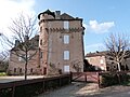
La Garinie Castle
.JPG)

Web links
Commons : Lugan - collection of images, videos and audio files