
Saint-Rémy (Aveyron)
|
Saint-Rémy Sent Remèsi |
||
|---|---|---|
|
||
| region | Occitania | |
| Department | Aveyron | |
| Arrondissement | Villefranche-de-Rouergue | |
| Canton | Villeneuvois et Villefranchois | |
| Community association | Grand Villefranchois | |
| Coordinates | 44 ° 24 ' N , 2 ° 2' E | |
| height | 290-486 m | |
| surface | 8.98 km 2 | |
| Residents | 317 (January 1, 2017) | |
| Population density | 35 inhabitants / km 2 | |
| Post Code | 12200 | |
| INSEE code | 12242 | |

Saint-Rémy ( Occitan Sent Remèsi ) is a French commune with 317 inhabitants (as of January 1, 2017) in the Aveyron department in the Occitania region (before 2016 Midi-Pyrénées ). The municipality belongs to the arrondissement of Villefranche-de-Rouergue and the canton of Villeneuvois et Villefranchois (until 2015 Villeneuve ). The inhabitants are called Saint-Rémois .
geography
Saint-Rémy is located about 50 kilometers west-northwest of Rodez . Saint-Rémy is surrounded by the neighboring communities of Villeneuve in the north and west, Maleville in the east, Villefranche-de-Rouergue in the south and Toulonjac in the southwest.
Population development
| year | 1962 | 1968 | 1975 | 1982 | 1990 | 1999 | 2006 | 2013 |
| Residents | 217 | 176 | 185 | 243 | 296 | 297 | 314 | 334 |
| Source: Cassini and INSEE | ||||||||
Attractions
- Church, monument historique since 1944
- 13th century castle
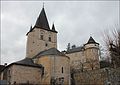
church

Castle


Web links
Commons : Saint-Rémy - Collection of images, videos and audio files