
La Salvetat-Peyralès
|
La Salvetat-Peyralès La Salvetat de Peiralés |
||
|---|---|---|
.svg)
|
|
|
| region | Occitania | |
| Department | Aveyron | |
| Arrondissement | Villefranche-de-Rouergue | |
| Canton | Aveyron et Tarn | |
| Community association | Aveyron Bas Ségala Viaur | |
| Coordinates | 44 ° 13 ' N , 2 ° 12' E | |
| height | 210-638 m | |
| surface | 54.24 km 2 | |
| Residents | 976 (January 1, 2017) | |
| Population density | 18 inhabitants / km 2 | |
| Post Code | 12440 | |
| INSEE code | 12258 | |

La Salvetat-Peyralès ( Occitan : La Salvetat (de Peiralés) ) is a French commune with 976 inhabitants (as of January 1, 2017) in the Aveyron department in the Occitania region (before 2016: Midi-Pyrénées ). It belongs to the arrondissement of Villefranche-de-Rouergue and the canton of Aveyron et Tarn (until 2015: canton of La Salvetat-Peyralès ).
geography
La Salvetat-Peyralès is located about 33 kilometers west-southwest of Rodez on the Viaur . La Salvetat-Peyralès is surrounded by the neighboring communities of La Capelle-Bleys in the north and northwest, Rieupeyroux in the north, Pradinas in the northeast, Tayrac in the east, Castelmary in the southeast, Mirandol-Bourgnounac in the south, Jouqueviel in the southwest, Lescure-Jaoul in the west as well Vabre-Tizac in the northwest.
Population development
| year | 1962 | 1968 | 1975 | 1982 | 1990 | 1999 | 2006 | 2013 |
| Residents | 1,860 | 1,672 | 1,478 | 1.311 | 1,162 | 1,062 | 1,067 | 983 |
| Source: Cassini and INSEE | ||||||||
Attractions
- Sainte-Croix church
- Murat Chapel, originally from the 11th century
- Romégous castle ruins
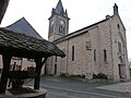
Sainte-Croix church
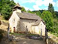
Murat Chapel

Roumégous castle ruins


