
Villeneuve (Aveyron)
|
Villeneuve Vilanòva |
||
|---|---|---|

|
|
|
| region | Occitania | |
| Department | Aveyron | |
| Arrondissement | Villefranche-de-Rouergue | |
| Canton | Villeneuvois et Villefranchois | |
| Community association | Grand Villefranchois | |
| Coordinates | 44 ° 26 ' N , 2 ° 2' E | |
| height | 295-505 m | |
| surface | 65.3 km 2 | |
| Residents | 1,988 (January 1, 2017) | |
| Population density | 30 inhabitants / km 2 | |
| Post Code | 12260 | |
| INSEE code | 12301 | |
| Website | www.villeneuve-aveyron.com | |
 Villeneuve Town Hall |
||

Villeneuve (also known as Villeneuve-d'Aveyron , Occitan : Villanòva ) is a southern French municipality with 1,988 inhabitants (as of January 1, 2017) in the Aveyron department in the Occitania region . The municipality belongs to the arrondissement of Villefranche-de-Rouergue and the canton of Villeneuvois et Villefranchois (until 2015: canton of Villeneuve ). The inhabitants are called Villeneuvois .
location

Villeneuve is about 44 kilometers west-northwest of Rodez . Villeneuve is surrounded by the neighboring communities of Foissac and Causse-et-Diège in the north, Salles-Courbatiès in the north-east, Saint-Igest in the east, Maleville in the south-east, Saint-Rémy and Toulonjac in the south, Sainte-Croix in the west and south-west, Ols- et-Rinhodes in the west and north-west and Montsalès in the north-west.
history
Villeneuve is a so-called count's bastide , which was founded by Raimund VII in 1231.
Population development
| year | 1962 | 1968 | 1975 | 1982 | 1990 | 1999 | 2006 | 2012 |
| Residents | 1,473 | 1,461 | 1,493 | 1,649 | 1,891 | 2.017 | 1999 | 1,947 |
| Source: Cassini and INSEE | ||||||||
Attractions
- Romanesque church of Saint-Sépulcre from the 11th century, monument historique since 1925
- Pre-Romanesque church of Saint-Pierre-et-Saint-Paul in Toulongergues , partly from the 5th century, monument historique since 1988
- Large gate ( Porte Haute ), now used as a prison, since 1928 Monument historique
- Cardalhac Gate, Monument historique since 1928
- 15th century house at Soubirane gate
- Toulongergues Castle
- Ginals Castle with chapel and donjon
- Pigeon tower , Monument historique since 2011

Saint-Sépulcre church

Saint-Pierre-et-Saint-Paul church

Big gate

Cardalhac Gate
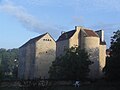
Toulongergues Castle

Ginals Castle


Personalities
- Bernard Dufour (1922–2016), painter and writer