Moyrazès
|
Moyrazès moirasés |
||
|---|---|---|

|
|
|
| region | Occitania | |
| Department | Aveyron | |
| Arrondissement | Villefranche-de-Rouergue | |
| Canton | Ceor-Ségala | |
| Community association | Pays Ségali | |
| Coordinates | 44 ° 21 ′ N , 2 ° 26 ′ E | |
| height | 430-773 m | |
| surface | 23.43 km 2 | |
| Residents | 1,109 (January 1, 2017) | |
| Population density | 47 inhabitants / km 2 | |
| Post Code | 12160 | |
| INSEE code | 12162 | |
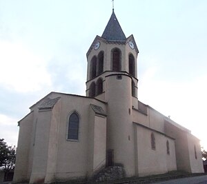
 Saint-Médard church |
||
Moyrazès ( Occitan : Moirasés ) is a French commune of the department of Aveyron with 1,109 inhabitants (as of January 1 2017) in the region Occitania . Administratively, it is assigned to the canton of Ceor-Ségala (until 2015: canton of Baraqueville-Sauveterre ) and the arrondissement of Villefranche-de-Rouergue .
geography
Moyrazès is located in one of the southwestern foothills of the Massif Central on the Ségala plateau in the historic Rouergue province about eight kilometers west of Rodez on the Aveyron , which borders the municipality in the north. Moyrazès is surrounded by the neighboring communities Clairvaux-d'Aveyron in the north, Druelle (since January 1, 2017: Druelle Balsac ) in the north and north-east, Baraqueville in the south and east, Boussac in the south-west, Colombiès in the west and Mayran in the north-west.
Population development
| year | 1936 | 1946 | 1954 | 1962 | 1968 | 1975 | 1982 | 1990 | 1999 | 2006 | 2013 |
|---|---|---|---|---|---|---|---|---|---|---|---|
| Residents | 1,753 | 1,750 | 1,588 | 1,542 | 1,461 | 1,382 | 1,130 | 1,087 | 1.109 | 1,100 | 1,132 |
| Source: Cassini and INSEE | |||||||||||
Attractions
- Saint-Médard church
- Le Cayla Castle
- Remains of the former Moyrazès castle
Personalities
- Antoine Boutonnet (1802–1868), Bishop of Basse-Terre et Pointe-à-Pitre (1862–1868)
