
Quins
| Quins | ||
|---|---|---|
|
||
| region | Occitania | |
| Department | Aveyron | |
| Arrondissement | Villefranche-de-Rouergue | |
| Canton | Ceor-Ségala | |
| Community association | Pays Ségali | |
| Coordinates | 44 ° 14 ' N , 2 ° 22' E | |
| height | 343-724 m | |
| surface | 38.46 km 2 | |
| Residents | 844 (January 1, 2017) | |
| Population density | 22 inhabitants / km 2 | |
| Post Code | 12800 | |
| INSEE code | 12194 | |
 Look at Quins |
||

Quins ( Occitan is identical) is a French commune of the department of Aveyron with 844 inhabitants (at January 1, 2017) in the region Occitania (before 2016 Midi-Pyrenees ). Administratively it is assigned to the canton Ceor-Ségala (until 2015 Naucelle ) and the arrondissement Villefranche-de-Rouergue . The inhabitants are called Quinsois .
geography
Quins is about nineteen kilometers southwest of Rodez in the Massif Central . Quins is surrounded by the neighboring communities of Gramond in the north, Baraqueville in the east and northeast, Camboulazet in the east and southeast, Camjac in the south and southeast, Naucelle in the south and Sauveterre-de-Rouergue in the west and northwest.
The national route 88 runs through the municipality .
Population development
| year | 1962 | 1968 | 1975 | 1982 | 1990 | 1999 | 2006 | 2013 |
|---|---|---|---|---|---|---|---|---|
| Residents | 1,218 | 1,053 | 886 | 715 | 717 | 644 | 764 | 826 |
| Source: Cassini and INSEE | ||||||||
Attractions
- Saint Vincent Church
- Saint Clair chapel in Verdun, a historic monument since 1999
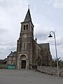
Aint-vincent church

Saint Clair Chapel

