
Martiel
| Martiel | ||
|---|---|---|
|
||
| region | Occitania | |
| Department | Aveyron | |
| Arrondissement | Villefranche-de-Rouergue | |
| Canton | Villeneuvois et Villefranchois | |
| Community association | Grand Villefranchois | |
| Coordinates | 44 ° 23 ' N , 1 ° 55' E | |
| height | 254-430 m | |
| surface | 46.71 km 2 | |
| Residents | 1,009 (January 1, 2017) | |
| Population density | 22 inhabitants / km 2 | |
| Post Code | 12350 | |
| INSEE code | 12140 | |
 City Hall (Mairie) by Martiel |
||

Martiel is a French commune with 1,009 inhabitants (as of January 1, 2017) in the Aveyron département in the Occitanie region (before 2016 Midi-Pyrénées ). The municipality belongs to the arrondissement of Villefranche-de-Rouergue and the canton of Villeneuvois et Villefranchois (until 2015 Villefranche-de-Rouergue ).
geography
Martiel is about 43 kilometers west of Rodez . Martiel is surrounded by the neighboring communities of Salvagnac-Cajarc and La Capelle-Balaguier in the north, Sainte-Croix in the northeast, Savignac in the east, Vailhourles in the south, Laramière in the west and Puyjourdes in the northwest.
Demographics
| year | 1962 | 1968 | 1975 | 1982 | 1990 | 1999 | 2006 | 2013 |
| Residents | 723 | 677 | 635 | 706 | 798 | 823 | 885 | 1.002 |
| Source: Cassini and INSEE | ||||||||
Attractions
- Dolmen du Bois de Galtier , Dolmen de l'Espinassière and Dolmen du Puech Mort
- church
- Loc-Dieu Monastery , Monument historique since 1989
- Tower of the Knights Templar
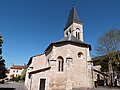
church

Tower of the Knights Templar

Loc-Dieu monastery


Web links
Commons : Martiel - collection of images, videos and audio files