
Saint-André-de-Najac
|
Saint-André-de-Najac Sent Andrieu de Najac |
||
|---|---|---|
|
||
| region | Occitania | |
| Department | Aveyron | |
| Arrondissement | Villefranche-de-Rouergue | |
| Canton | Aveyron et Tarn | |
| Community association | Grand Villefranchois | |
| Coordinates | 44 ° 11 ′ N , 2 ° 2 ′ E | |
| height | 150-437 m | |
| surface | 25.1 km 2 | |
| Residents | 442 (January 1, 2017) | |
| Population density | 18 inhabitants / km 2 | |
| Post Code | 12270 | |
| INSEE code | 12210 | |
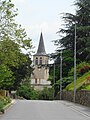
 View of Saint-André-de-Najac |
||

Saint-André-de-Najac ( Occitan Sent Andrieu de Najac ) is a French commune with 442 inhabitants (as of January 1, 2017) in the Aveyron department in the Occitania region (before 2016 Midi-Pyrénées ). The municipality belongs to the arrondissement of Villefranche-de-Rouergue and the canton of Aveyron et Tarn (until 2015 Najac ). The inhabitants are called Saint-Andréens .
geography
Saint-André-de-Najac is located about 52 kilometers west-southwest of Rodez between Aveyron and Viaur . Saint-André-de-Najac is surrounded by the neighboring communities of Najac in the north and north-west, La Fouillade in the north, Bor-et-Bar in the north-east, Montirat in the east, Saint-Christophe in the south and south-east, and Saint-Martin-Laguépie in the south-west as well as Laguépie in the west and south-west.
Population development
| year | 1962 | 1968 | 1975 | 1982 | 1990 | 1999 | 2006 | 2013 |
| Residents | 625 | 550 | 540 | 509 | 426 | 373 | 408 | 419 |
| Source: Cassini and INSEE | ||||||||
Attractions
- church
- Notre-Dame chapel in Laval
- Watermill
Saint-André church

Notre-Dame chapel

Watermill


.JPG)