
Vailhourles
|
Vailhourles Valhorlhas |
||
|---|---|---|
|
||
| region | Occitania | |
| Department | Aveyron | |
| Arrondissement | Villefranche-de-Rouergue | |
| Canton | Villefranche-de-Rouergue | |
| Community association | Grand Villefranchois | |
| Coordinates | 44 ° 18 ′ N , 1 ° 54 ′ E | |
| height | 275-437 m | |
| surface | 32.41 km 2 | |
| Residents | 634 (January 1, 2017) | |
| Population density | 20 inhabitants / km 2 | |
| Post Code | 12200 | |
| INSEE code | 12287 | |
 Town Hall (Mairie) of Vailhourles |
||

Vailhourles ( Occitan : Valhorlhas ) is a French commune with 634 inhabitants (as of January 1, 2017) in the Aveyron department in the Occitanie region . It belongs to the arrondissement of Villefranche-de-Rouergue and the canton of Villefranche-de-Rouergue . The inhabitants are called Vailhourlais .
geography
Vailhourles is about 50 kilometers north-northwest of Albi and about 60 kilometers west-southwest of Rodez . Neighboring communities are Martiel in the north, Savignac in the northeast, La Rouquette in the east, Castanet in the south and southeast, Parisot in the south and southwest and Puylagarde in the west.
Population development
| year | 1962 | 1968 | 1975 | 1982 | 1990 | 1999 | 2006 | 2013 |
| Residents | 666 | 615 | 564 | 556 | 535 | 511 | 600 | 709 |
| Source: Cassini and INSEE | ||||||||
Attractions
- Saint-Grat church
- Saint-Fiacre chapel

Saint-Grat church
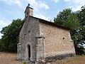
Saint-Fiacre chapel


Web links
Commons : Vailhourles - collection of pictures, videos and audio files