
Mayran
|
Mayran Mairanh |
||
|---|---|---|
|
||
| region | Occitania | |
| Department | Aveyron | |
| Arrondissement | Villefranche-de-Rouergue | |
| Canton | Enne and Alzou | |
| Community association | Pays Rignacois | |
| Coordinates | 44 ° 23 ' N , 2 ° 22' E | |
| height | 400-734 m | |
| surface | 15.36 km 2 | |
| Residents | 635 (January 1, 2017) | |
| Population density | 41 inhabitants / km 2 | |
| Post Code | 12390 | |
| INSEE code | 12142 | |
| Website | http://www.mayran.fr/ | |

Mayran ( Occitan : Mairanh ) is a French commune with 635 inhabitants (as of January 1, 2017) in the Aveyron department , Occitania region (before 2016: Midi-Pyrénées ). It belongs to the arrondissement of Villefranche-de-Rouergue and the canton Enne et Alzou (until 2015: canton Rignac ). The inhabitants are called Mayrannais .
geography
Mayran is about 19 kilometers west-northwest of Rodez . Mayran is surrounded by the neighboring communities Clairvaux-d'Aveyron in the north and east, Moyrazès in the southeast, Colombiès in the south and Belcastel in the west.
Population development
| 1962 | 1968 | 1975 | 1982 | 1990 | 1999 | 2006 | 2013 |
|---|---|---|---|---|---|---|---|
| 593 | 565 | 520 | 492 | 472 | 454 | 499 | 651 |
| Source: Cassini and INSEE | |||||||
Attractions
- Saint-Fabien and Saint-Sébastien Church
- Ruffepeyre tithe barn, monument historique since 2002
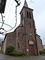
Saint-Fabien and Saint-Sébastien Church
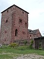
Tithe barn


Web links
Commons : Mayran - Collection of images, videos and audio files