Tayrac (Aveyron)
|
Tayrac Tairac |
||
|---|---|---|
|
|
||
| region | Occitania | |
| Department | Aveyron | |
| Arrondissement | Villefranche-de-Rouergue | |
| Canton | Aveyron et Tarn | |
| Community association | Aveyron Bas Ségala Viaur | |
| Coordinates | 44 ° 12 ' N , 2 ° 14' E | |
| height | 276-536 m | |
| surface | 15.73 km 2 | |
| Residents | 176 (January 1, 2017) | |
| Population density | 11 inhabitants / km 2 | |
| Post Code | 12440 | |
| INSEE code | 12278 | |
| Website | http://www.tayrac.fr/ | |
 Tayrac Town Hall (Mairie) |
||
Tayrac ( Occitan : Tairac ) is a French commune with 176 inhabitants (as of January 1, 2017) in the Aveyron department in the Occitania region (before 2016: Midi-Pyrénées ). It belongs to the arrondissement of Villefranche-de-Rouergue and the canton of Aveyron et Tarn (until 2015: canton of La Salvetat-Peyralès ). The inhabitants are called Tayracois .
geography
Tayrac is about 31 kilometers southwest of Rodez . At the eastern border of the municipality, the Lieux de Villelongue river flows into the Lézert . Tayrac is surrounded by the neighboring communities of La Salvetat-Peyralès in the north and west, Pradinas in the northeast, Cabanès in the east and Castelmary in the south.
Population development
| year | 1962 | 1968 | 1975 | 1982 | 1990 | 1999 | 2006 | 2013 |
| Residents | 318 | 313 | 300 | 290 | 190 | 174 | 172 | 161 |
| Source: Cassini and INSEE | ||||||||
Attractions
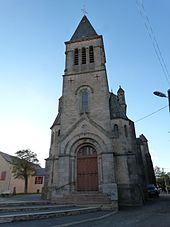
- Saint-Jean-Baptiste church
Web links
Commons : Tayrac - collection of images, videos and audio files

