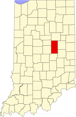
Madison County (Indiana)
 Madison County Government Center and Courts |
|
| administration | |
|---|---|
| US state : | Indiana |
| Administrative headquarters : | Anderson |
| Foundation : | July 1, 1823 |
| Demographics | |
| Residents : | 131,636 (2010) |
| Population density : | 112.4 inhabitants / km 2 |
| geography | |
| Total area : | 1173 km² |
| Water surface : | 2 km² |
| map | |
| Website : www.madisoncty.com | |
Madison County is a county in the US state of Indiana in the United States . The seat of the county government is Anderson .
geography
Madison County is 1,173 square kilometers, of which two square kilometers are covered with water; Water covers 0.17 percent of the county's surface.
The neighboring counties starting clockwise from the north are Grant County , Delaware County , Henry County , Hancock County , Hamilton County, and Tipton County .
history
| Population development | |||
|---|---|---|---|
| Census | Residents | ± in% | |
| 1830 | 2238 | - | |
| 1840 | 8874 | 296.5% | |
| 1850 | 12,375 | 39.5% | |
| 1860 | 16,518 | 33.5% | |
| 1870 | 22,770 | 37.8% | |
| 1880 | 27,527 | 20.9% | |
| 1890 | 36,487 | 32.5% | |
| 1900 | 70,470 | 93.1% | |
| 1910 | 65,224 | -7.4% | |
| 1920 | 69,151 | 6% | |
| 1930 | 82,888 | 19.9% | |
| 1940 | 88,575 | 6.9% | |
| 1950 | 103,911 | 17.3% | |
| 1960 | 125,819 | 21.1% | |
| 1970 | 138,451 | 10% | |
| 1980 | 139,336 | 0.6% | |
| 1990 | 130,669 | -6.2% | |
| 2000 | 133,358 | 2.1% | |
| 2010 | 131,636 | -1.3% | |
| Before 1900
1900–1990 2000 + 2010 |
|||
Madison County was founded on July 1, 1983. It was named after James Madison , the fourth President of the United States (1809-1817).
The first seat of county government was Pendleton in 1823. The place was too far from the center of the county and to this day it is not clear whether this was chosen or whether it was due to the fact that the legal business was carried out there at that time. Pendleton later became the first place where a white man was executed for killing a Native American who died by hanging.
After a resolution of January 13, 1826, Bedford, a now defunct place, was designated as the new county seat. On January 4, 1827, it was decided that Anderson would be the new seat of the county government.
Anderson was an old Indian town of the Delaware tribe , named after its chief Anderson . The place was burned down by troops from Kentucky in 1813 . By 1849, Anderson had a courthouse, prison, volunteer fire department, and around 300 residents. The district court building was destroyed by fire on December 10, 1880, and with it most of the important documents.
17 buildings and sites in the county are listed on the National Register of Historic Places (as of September 2, 2017).
Places in the county
- Alexandria
- Alfont
- Alliance
- Anderson
- Bloomer
- Brentwood
- Chesterfield
- College Corner
- Country Club Heights
- Crestlawn
- Dundee
- Eastern Heights
- Edgewood
- Edgewood Village
- Elmhurst
- Elwood
- Emporia
- Extension Heights
- Fairfax
- Fishersburg
- Florida
- Forest Hills
- Frankton
- Gimco City
- Glyn Ellen
- Grandview
- Gridley
- Hamilton
- Hard scrabble
- Harmeson Heights
- Hillcrest
- Huntsville
- Ingalls
- Irondale
- Lapel
- Leisure
- Linwood
- Low mandals
- Markleville
- Meadowbrook
- Moonville
- New Columbus
- North Anderson
- Orestes
- Pendleton
- Perkinsville
- Prosperity
- River Forest
- South Edgewood
- South Elwood
- Summitville
- Sunview
- West Elwood
- Western Village
- Woodlawn Heights
Individual evidence
- ↑ GNIS-ID: 450370. Retrieved on February 22, 2011 (English).
- ↑ US Census Bureau - Census of Population and Housing . Retrieved March 15, 2011
- ↑ Extract from Census.gov . Retrieved February 16, 2011
- ↑ Extract from census.gov (2000 + 2010) ( Memento of the original from July 14, 2011 on WebCite ) Info: The archive link was automatically inserted and not yet checked. Please check the original and archive link according to the instructions and then remove this notice. Retrieved April 2, 2012
- ↑ Search mask database in the National Register Information System. National Park Service , accessed September 2, 2017.
Web links
Coordinates: 40 ° 10 ′ N , 85 ° 43 ′ W


