
Retuerta (Burgos)
| Retuerta municipality | |||
|---|---|---|---|
 Retuerta - View of the town with the Ermita de Santa María
|
|||
| coat of arms | Map of Spain | ||
 Help on coat of arms |
|
||
| Basic data | |||
| Autonomous Community : |
|
||
| Province : | Burgos | ||
| Comarca : | Arlanza (Comarca) | ||
| Coordinates | 42 ° 2 ′ N , 3 ° 30 ′ W | ||
| Height : | 910 msnm | ||
| Area : | 8.54 km² | ||
| Residents : | 63 (Jan. 1, 2019) | ||
| Population density : | 7.38 inhabitants / km² | ||
| Postal code : | 09347 | ||
| Municipality number ( INE ): | 09311 | ||
| administration | |||
| Website : | Retuerta | ||

Retuerta is a northern Spanish town and municipality ( municipio ) with only 63 inhabitants (as of January 1, 2019) in the south of the province of Burgos in the autonomous community of Castile and León . The place is on the Camino del Cid and on the Camino de la Lana coming from Alicante , an old trade route and a feeder of the Camino de Santiago .
Location and climate
The place Retuerta lies above a loop of the Río Arlanza at an altitude of about 910 m, a good 45 km (driving distance) southeast of Burgos . The small towns of Covarrubias and Lerma are only about 5 km north and 27 km west, respectively. The climate in winter is quite rough, but in summer it is dry and warm; Rain (approx. 525 mm / year) falls mainly in the winter half-year.
Population development
| year | 1857 | 1900 | 1950 | 2000 | 2018 |
| Residents | 745 | 549 | 215 | 72 | 59 |
The constant population decline since the middle of the 19th century is due to the mechanization of agriculture and the abandonment of small farms ( rural exodus ).
economy
The area around Retuerta is dominated by agriculture; For a long time the place offered the necessary regional services in the fields of handicraft and trade. Many holiday homes (casas rurales) and apartments have been rented out since the middle of the 20th century . Since 2008, the municipality has been part of the Arlanza wine region (DO) .
history
Retuerta is mentioned for the first time in a document from the year 987. Otherwise, the place has largely experienced the same history as the neighboring towns of Covarrubias and Lerma.

Attractions
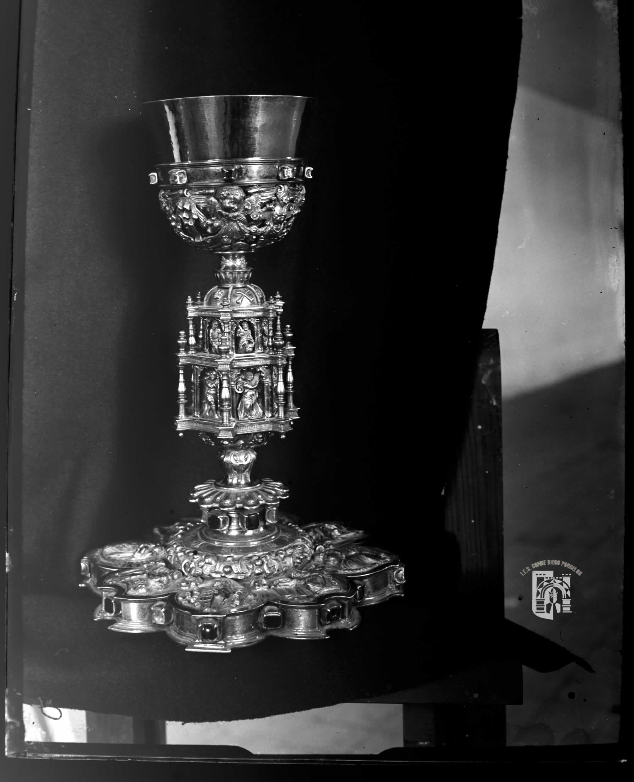
- The Iglesia de San Esteban was built in the 17th century and its architecture indicates the former importance of the place. With the exception of the gable portal and the round window above, the facade is unadorned, which refers to the late Herrera style ; the south portal is designed in a similar way. In the single-nave interior there are three wooden sculptures from the 13th century; a precious chalice (calíz) from around 1600 is the jewel of the church.
- Surroundings
- Approx. 1 km outside the town stands, built in the 16th century as a parish church by a bell gable (espadaña) excessive Ermita de Santa María , which represents a year once the target of a procession. The portal is on the south side; the vestibule is compared with the nave (nature) increased by about 2 m.
Web links
- Retuerta - Photos + Info (wikiburgos, Spanish)
- Retuerta, historical buildings - photos + information (Spanish)
Individual evidence
- ↑ Cifras oficiales de población resultantes de la revisión del Padrón municipal a 1 de enero . Population statistics from the Instituto Nacional de Estadística (population update).
- ↑ Retuerta - climate tables
- ^ Retuerta - population development
- ↑ Retuerta - Chalice
Abajas | Adrada de Haza | Aguas Cándidas | Aguilar de Bureba | Albillos | Alcocero de Mola | Alfoz de Bricia | Alfoz de Quintanadueñas | Alfoz de Santa Gadea | Altable | Los Altos | Ameyugo | Anguix | Aranda de Duero | Arandilla | Arauzo de Miel | Arauzo de Salce | Arauzo de Torre | Arcos | Arenillas de Riopisuerga | Arija | Arlanzón | Arraya de Oca | Atapuerca | Los Ausines | Avellanosa de Muñó | Bahabón de Esgueva | Los Balbases | Baños de Valdearados | Bañuelos de Bureba | Barbadillo de Herreros | Barbadillo del Mercado | Barbadillo del Pez | Barrio de Muñó | Los Barrios de Bureba | Barrios de Colina | Basconcillos del Tozo | Bascuñana | Belbimbre | Belorado | Berberana | Berlangas de Roa | Berzosa de Bureba | Bozoó | Brazacorta | Briviesca | Bugedo | Buniel | Burgos | Busto de Bureba | Cabañes de Esgueva | Cabezón de la Sierra | Caleruega | Campillo de Aranda | Campolara | Canicosa de la Sierra | Cantabrana | Carazo | Carcedo de Bureba | Carcedo de Burgos | Cardeñadijo | Cardeñajimeno | Cardeñuela Riopico | Carrias | Cascajares de Bureba | Cascajares de la Sierra | Castellanos de Castro | Castil de Peones | Castildelgado | Castrillo de la Reina | Castrillo de la Vega | Castrillo de Riopisuerga | Castrillo del Val | Castrillo Mota de Judíos | Castrojeriz | Cavy | Cayuela | Cebrecos | Celada del Camino | Cerezo de Río Tirón | Cerratón de Juarros | Ciadoncha | Cillaperlata | Cilleruelo de Abajo | Cilleruelo de Arriba | Ciruelos de Cervera | Cogollos | Condado de Treviño | Contreras | Coruña del Conde | Covarrubias | Cubillo del Campo | Cubo de Bureba | La Cueva de Roa | Cuevas de San Clemente | Encío | Espinosa de Cervera | Espinosa de los Monteros | Espinosa del Camino | Estépar | Fontioso | Frandovínez | Fresneda de la Sierra Tirón | Fresneña | Fresnillo de las Dueñas | Fresno de Río Tirón | Fresno de Rodilla | Frías | Fuentebureba | Fuentecén | Fuentelcésped | Fuentelisendo | Fuentemolinos | Fuentenebro | Fuentespina | Galbarros | La Gallega | Grijalba | Grisaleña | Gumiel de Izán | Gumiel de Mercado | Hacinas | Haza | Hontanas | Hontangas | Hontoria de la Cantera | Hontoria de Valdearados | Hontoria del Pinar | Las Hormazas | Hornillos del Camino | La Horra | Hortigüela | Hoyales de Roa | Huérmeces | Huerta de Arriba | Huerta de Rey | Humada | Hurones | Ibeas de Juarros | Ibrillos | Iglesiarrubia | Iglesias | Isar | Itero del Castillo | Jaramillo de la Fuente | Jaramillo Quemado | Junta de Traslaloma | Junta de Villalba de Losa | Jurisdicción de Lara | Jurisdicción de San Zadornil | Lerma | Llano de Bureba | Madrigal del Monte | Madrigalejo del Monte | Mahamud | Mambrilla de Castrejón | Mambrillas de Lara | Mamolar | Manciles | Mazuela | Mecerreyes | Medina de Pomar | Melgar de Fernamental | Merindad de Cuesta-Urria | Merindad de Montija | Merindad de Río Ubierna | Merindad de Sotoscueva | Merindad de Valdeporres | Merindad de Valdivielso | Milagros | Miranda de Ebro | Miraveche | Modúbar de la Emparedada | Monasterio de la Sierra | Monasterio de Rodilla | Moncalvillo | Monterrubio de la Demanda | Montorio | Moradillo de Roa | Nava de Roa | Navas de Bureba | Nebreda | Neila | Olmedillo de Roa | Olmillos de Muñó | Oña | Oquillas | Orbaneja Riopico | Padilla de Abajo | Padilla de Arriba | Padrones de Bureba | Palacios de la Sierra | Palacios de Riopisuerga | Palazuelos de la Sierra | Palazuelos de Muñó | Pampliega | Pancorbo | Pardilla | Partido de la Sierra en Tobalina | Pedrosa de Duero | Pedrosa de Río Úrbel | Pedrosa del Páramo | Pedrosa del Príncipe | Peñaranda de Duero | Peral de Arlanza | Piérnigas | Pineda de la Sierra | Pineda Trasmonte | Pinilla de los Barruecos | Pinilla de los Moros | Pinilla Trasmonte | Poza de la Sal | Prádanos de Bureba | Pradoluengo | Presencio | La Puebla de Arganzón | Puentedura | Quemada | Quintana del Pidio | Quintanabureba | Quintanaélez | Quintanaortuño | Quintanapalla | Quintanar de la Sierra | Quintanavides | Quintanilla de la Mata | Quintanilla del Agua y Tordueles | Quintanilla del Coco | Quintanilla San García | Quintanilla Vivar | Las Quintanillas | Rabanera del Pinar | Rábanos | Rabé de las Calzadas | Rebolledo de la Torre | Redecilla del Camino | Redecilla del Campo | Regumiel de la Sierra | Reinoso | Retuerta | Revilla del Campo | Revilla Vallejera | La Revilla y Ahedo | Revillarruz | Rezmondo | Riocavado de la Sierra | Roa | Rojas | Royuela de Río Franco | Rubena | Rublacedo de Abajo | Rucandio | Salas de Bureba | Salas de los Infantes | Saldaña de Burgos | Salinillas de Bureba | San Adrián de Juarros | San Juan del Monte | San Mamés de Burgos | San Martín de Rubiales | San Millán de Lara | San Vicente del Valle | Santa Cecilia | Santa Cruz de la Salceda | Santa Cruz del Valle Urbión | Santa Gadea del Cid | Santa Inés | Santa María del Campo | Santa María del Invierno | Santa María del Mercadillo | Santa María Rivarredonda | Santa Olalla de Bureba | Santibáñez de Esgueva | Santibáñez del Val | Santo Domingo de Silos | Sargentes de la Lora | Sarracín | Sasamón | La Sequera de Haza | Solarana | Sordillos | Sotillo de la Ribera | Sotragero | Sotresgudo | Susinos del Páramo | Tamarón | Tardajos | Tejada | Terradillos de Esgueva | Tinieblas de la Sierra | Tobar | Tordómar | Torrecilla del Monte | Torregalindo | Torrelara | Torrepadre | Torresandino | Tórtoles de Esgueva | Tosantos | Trespaderne | Tubilla del Agua | Tubilla del Lago | Úrbel del Castillo | Vadocondes | Valdeande | Valdezate | Valdorros | Vallarta de Bureba | Valle de las Navas | Valle de Losa | Valle de Manzanedo | Valle de Mena | Valle de Oca | Valle de Santibáñez | Valle de Sedano | Valle de Tobalina | Valle de Valdebezana | Valle de Valdelaguna | Valle de Valdelucio | Valle de Zamanzas | Vallejera | Valles de Palenzuela | Valluércanes | Valmala | La Vid de Bureba | La Vid y Barrios | Vileña | Villadiego | Villaescusa de Roa | Villaescusa la Sombría | Villaespasa | Villafranca Montes de Oca | Villafruela | Villagalijo | Villagonzalo Pedernales | Villahoz | Villalba de Duero | Villalbilla de Burgos | Villalbilla de Gumiel | Villaldemiro | Villalmanzo | Villamayor de los Montes | Villamayor de Treviño | Villambistia | Villamedianilla | Villamiel de la Sierra | Villangómez | Villanueva de Argaño | Villanueva de Carazo | Villanueva de Gumiel | Villanueva de Teba | Villaquirán de la Puebla | Villaquirán de los Infantes | Villarcayo de Merindad de Castilla la Vieja | Villariezo | Villasandino | Villasur de Herreros | Villatuelda | Villaverde del Monte | Villaverde-Mogina | Villayerno Morquillas | Villazopeque | Villegas | Villoruebo | Viloria de Rioja | Vilviestre del Pinar | Vizcaínos | Zael | Zarzosa de Río Pisuerga | Zazuar | Zuñeda