
Séglien
|
Séglien Seglian |
||
|---|---|---|
|
||
| region | Brittany | |
| Department | Morbihan | |
| Arrondissement | Pontivy | |
| Canton | Gourin | |
| Community association | Pontivy Communauté | |
| Coordinates | 48 ° 6 ′ N , 3 ° 9 ′ W | |
| height | 123-248 m | |
| surface | 38.36 km 2 | |
| Residents | 669 (January 1, 2017) | |
| Population density | 17 inhabitants / km 2 | |
| Post Code | 56160 | |
| INSEE code | 56242 | |
| Website | http://www.seglien.fr/ | |

Séglien ( Breton : Seglian ) is a French municipality with 669 inhabitants (at January 1, 2017) in the department of Morbihan in the region of Brittany . It belongs to the community association Pontivy Communauté .
geography
Séglien is located in the north of the Morbihan department and belongs to the Pays de Pontivy.
Neighboring municipalities are Silfiac in the north, Cléguérec in the east, Malguénac in the southeast, Guern in the south, Locmalo in the southwest and Langoëlan in the west.
The place is a bit away from roads for national traffic on the D18. The most important regional road connection is the D782 from Guémené-sur-Scorff to Pontivy , which passes a few kilometers away in the south. The closest connection to the N164 is around twenty kilometers further north.
The most important bodies of water are the Sarre River and the Moulin du Pont Houarn , Lanhouellic , Le Frétu , Manè Crez and Trescoët streams . These also partially form the municipal boundary. There are also some small ponds in the municipality. A small part of the community area is covered by forest areas.
Population development
| year | 1962 | 1968 | 1975 | 1982 | 1990 | 1999 | 2006 |
| Residents | 1,299 | 1,115 | 902 | 804 | 724 | 709 | 714 |
history
Historically, the municipality belongs to the Breton region of Bro Gwened (French: Vannetais) and within this region to the Bro Bourlet (French: Pays Pourlet) area and shares its history. Séglien has belonged to the canton of Cléguérec since 1793.
Attractions
See also: List of Monuments historiques in Séglien
- Notre-Dame-de-Lorette village church from 1640 with extensions from the 19th century
- Saint-Germain chapel in the town of the same name from the 15th and 16th centuries; restored in 1893
- Chapel of Saint-Jean near Guergomel from the 16th century
- Saint-Zénon chapel in the town of the same name from the 17th century
- Notre-Dame de Locmaria chapel in Locmaria-Coëtanfao from the 15th and 16th centuries
- Le Clandy prayer house in Séglien (on the road to Guern) from 1614
- Coëtanfao Castle (also Coët-an-Fao) from the 17th century
- Kergohan manor from 1651
- several old houses like Treuzar Bras (1650), Treuzar Bihan (1764) and in Saint-Germain opposite the chapel (16th century)
- Fontaine de dévotion fountain in Locmaria from 1695
- Well by Treuzar Bihan
- old oven from Treuzar Bras
- eight old mills (including two windmills and six water mills) in Mané-Guégan, Trescoët, Pont Houarn, de la Sarre, Trescat and Sylvestre
- Roman milestone west of Saint-Germain

Bread oven at the Saint-Germain chapel

Saint Germain Chapel
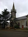
Notre-Dame-de-Lorette village church in Séglien

Milestone of the old Roman road


literature
- Le Patrimoine des Communes du Morbihan. Flohic Editions, Volume 1, Paris 1996, ISBN 2-84234-009-4 , pp. 196-199.
Individual evidence
- ↑ Official website of the CC du Pays de PontivyCC (French)
- ↑ Map with the municipalities of the Pays de Pontivy ( Memento of the original from January 11, 2012 in the Internet Archive ) Info: The archive link has been inserted automatically and has not yet been checked. Please check the original and archive link according to the instructions and then remove this notice.
- ↑ Séglien on Cassini.ehess.fr (French)
- ↑ Sights of the community ( Memento of the original dated August 12, 2012 in the Internet Archive ) Info: The archive link was inserted automatically and has not yet been checked. Please check the original and archive link according to the instructions and then remove this notice. (French)