
Guiscriff
|
Guiscriff Gwiskri |
||
|---|---|---|
|
||
| region | Brittany | |
| Department | Morbihan | |
| Arrondissement | Pontivy | |
| Canton | Gourin | |
| Community association | Roi Morvan Community | |
| Coordinates | 48 ° 3 ′ N , 3 ° 39 ′ W | |
| height | 70-237 m | |
| surface | 85.46 km 2 | |
| Residents | 2,088 (January 1, 2017) | |
| Population density | 24 inhabitants / km 2 | |
| Post Code | 56560 | |
| INSEE code | 56081 | |
| Website | http://www.guiscriff.fr | |

Guiscriff ( Breton : Gwiskri ) is a French municipality with 2088 inhabitants (at January 1, 2017) in the department of Morbihan in the region of Brittany . It belongs to the community association Roi Morvan Communauté .
geography
Guiscriff is located in the north-west of the Morbihan department on the border with the Finistère department and belongs to the Pays du Roi Morvan.
Neighboring municipalities are Roudouallec in the north, Gourin and Le Saint in the northeast, Le Faouët in the east, Lanvénégen in the southeast and the municipalities of Querrien and Saint-Thurien in the south and Scaër in the west.
The place itself is a bit away from important thoroughfares. About ten kilometers east of Guiscriff, the D769 runs from Saint-Pol-de-Léon to Lorient . The most important national road connection is the N165 further south. West of the village is the Aérodrome Bretagne Atlantique airfield .
The most important bodies of water are the Inam River and the St. Antoine , St. Jean , Kergonan , Kerlavarec , Pont Malagas and Goarem Clujiry brooks . There are several ponds in the municipality.
Population development
| year | 1962 | 1968 | 1975 | 1982 | 1990 | 1999 | 2006 |
| Residents | 3,740 | 3,377 | 2,931 | 2,734 | 2,529 | 2,394 | 2,319 |
history
Historically, the municipality belongs to the Breton region of Kernev (French Cornouaille ) and within this region to the Aven region (French also) and shares its history. Guiscriff belonged to the canton of Lanvénégen from 1793 until its dissolution in 1801. Since then, the place has been assigned to the canton of Le Faouët.
Attractions
See also: List of Monuments historiques in Guiscriff
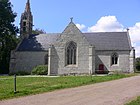
- Village church of Saint-Pierre et Saint-Paul from the 15th and 16th centuries
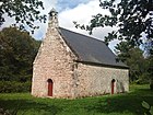
- Saint-Maudé (also Saint-Mandé ) chapel from the 15th and 16th centuries
- Saint-Eloi chapel from the 15th and 16th centuries
- Saint-Antoine chapel from the 16th century
- Saint-Mathurin chapel in Kerglaz from the 18th century
- Saint-Tugdual chapel from the 17th century
- Notre-Dame chapel (also Locmaria) in Locmaria from the 16th century
- former chapel Saint-Gwenaël (also Saint-Guénaël) from the 17th century
- Calvaries near the village church and in Pennevern, Cadigué and Kergroas
- Kerviniou dolmen
- 17th century Saint-Eloi fountain
- Castle of Kerandraon
- former manor house of Pénéhoc from the 15th and 16th centuries
- Kerglèmes district with houses from the 17th and 18th centuries
- twelve old mills

The Mayor's Office in Guiscriff

South view of the village church of Saint-Pierre et Saint-Paul in Guiscriff

Saint-Maudé chapel
Saint-Antoine chapel

Interior view of the Saint-Eloi church
Saint-Gwenaël Chapel
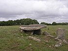
Kerviniou dolmen

Saint-Tugdual chapel


literature
- Le Patrimoine des Communes du Morbihan. Flohic Editions, Volume 1, Paris 1996, ISBN 2-84234-009-4 , pp. 256-259.
Individual evidence
- ^ Map with the municipalities of the Pays du Roi Morvan
- ↑ Guiscriff on Cassini.ehess.fr (French)
- ↑ Sights (French)
- ↑ Sights of the community ( Memento of the original from July 5, 2013 in the Internet Archive ) Info: The archive link was inserted automatically and has not yet been checked. Please check the original and archive link according to the instructions and then remove this notice. (French)