
Guern
|
Guern Gwern |
||
|---|---|---|
|
||
| region | Brittany | |
| Department | Morbihan | |
| Arrondissement | Pontivy | |
| Canton | Pontivy | |
| Community association | Pontivy Communauté | |
| Coordinates | 48 ° 2 ′ N , 3 ° 5 ′ W | |
| height | 67-188 m | |
| surface | 47.01 km 2 | |
| Residents | 1,306 (January 1, 2017) | |
| Population density | 28 inhabitants / km 2 | |
| Post Code | 56310 | |
| INSEE code | 56076 | |
| Website | http://guern.free.fr/accueil.html | |

Guern ( Breton : Gwern ) is a French municipality with 1306 inhabitants (at January 1, 2017) in the department of Morbihan in the region of Brittany . It belongs to the community association Pontivy Communauté .
geography
Guern is located in the north of the Morbihan department and belongs to the Pays de Pontivy.
Neighboring communities are Séglien in the north, Malguénac in the northeast, Le Sourn in the east, Pluméliau-Bieuzy with Bieuzy in the southeast, Melrand in the south, Bubry in the southwest and Locmalo in the northwest.
The place is a bit away from roads for national traffic. The most important road connection is the D700 / D768 (formerly Route nationale 168 ), which passes more than ten kilometers east of the municipality. The D1 runs through the town itself from Roudouallec to Péaule , a road connection across the entire Morbihan department.
The most important body of water is the Sarre River , which flows through the western part of the municipality.
Population development
| year | 1962 | 1968 | 1975 | 1982 | 1990 | 1999 | 2006 |
| Residents | 1,896 | 1,670 | 1,555 | 1,534 | 1,409 | 1,398 | 1,445 |
history
Historically, the municipality belongs to the Breton region of Bro Gwened (French: Vannetais) and within this region to the Bro Pondi (French: Pays de Pontivy) area and shares its history. From 1793 until its dissolution in 1801, Guern belonged to the canton of Melrand. Since then, the place has been assigned to the canton of Pontivy.
Attractions
See also: List of the Monuments historiques in Guern
- Village church of Saint-Pierre et Saint-Paul from 1788 with cult objects from the previous church from the 15th century
- Chapel of Our Lady of Quelven from the 15th century with root Jesse window and Christopher window
- Chapel Saint-Jean from the 17th century (partly 1585) in the town of the same name
- other old chapels ( Saint-Meldéoc in Locmeltro, Saint-Salomon in Saint-Salomon and Saint-Georges in Boderel)
- Ménorval mansion from 1558 in Mané-er-Val
- House of the devil from the 17th century in Locmeltro
- Chaumière (thatched house) from 1639
- Scala Sancta from the 18th century
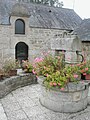
- Fountain of Quelven
- old oven Four banal from the 16th century in Saint-Jean
- thirteen old mills (windmill in Kerdisson and water mills in Kerali, Kerhiec, Pont de Quelven, Quillio, Guermeur, Stand Du, Niziau, Spiric, Saint-Jean, Henven, Le Pontou)
- Devil menhir by Kerhiec
- Remains of the Roman road Vannes-Carhaix
- 40 km long way of the cross
The mayor's office in Guern

The Menorval mansion

View of the Gallo-Roman ossuary in Guern
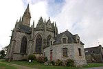
The Notre-Dame chapel in Quelven

In the Notre-Dame chapel in Quelven

The Virgin in the Notre-Dame Chapel in Quelven


literature
- Le Patrimoine des Communes du Morbihan. Flohic Editions, Volume 2, Paris 1996, ISBN 2-84234-009-4 , pp. 727-731.
Individual evidence
- ↑ Official website of the CC du Pays de PontivyCC (French)
- ↑ Map with the municipalities of the Pays de Pontivy ( Memento of the original from January 11, 2012 in the Internet Archive ) Info: The archive link has been inserted automatically and has not yet been checked. Please check the original and archive link according to the instructions and then remove this notice.
- ↑ Guern on Cassini.ehess.fr (French)
- ↑ Sights of the community ( Memento of the original from October 7, 2013 in the Internet Archive ) Info: The archive link was inserted automatically and has not yet been checked. Please check the original and archive link according to the instructions and then remove this notice. (French)