
Lignol
|
Lignol to Ignol |
||
|---|---|---|
|
||
| region | Brittany | |
| Department | Morbihan | |
| Arrondissement | Pontivy | |
| Canton | Gourin | |
| Community association | Roi Morvan Community | |
| Coordinates | 48 ° 2 ′ N , 3 ° 16 ′ W | |
| height | 93-187 m | |
| surface | 38.43 km 2 | |
| Residents | 853 (January 1, 2017) | |
| Population density | 22 inhabitants / km 2 | |
| Post Code | 56160 | |
| INSEE code | 56110 | |

Lignol ( Breton : An Ignol ) is a French municipality with 853 inhabitants (at January 1, 2017) in the department of Morbihan in the region of Brittany . It belongs to the community association Roi Morvan Communauté .
geography
Lignol is located in the northwest of the Morbihan department and is part of the Pays du Roi Morvan.
Neighboring communities are Ploërdut in the north, Locmalo in the northeast, Persquen in the east, Inguiniel in the south and Kernascléden and Saint-Caradec-Trégomel in the west.
The place itself is far away from important thoroughfares on the D782. The most important regional road connection D769 from Saint-Pol-de-Léon to Lorient runs around 14 kilometers west of the town.
The most important bodies of water are the Scorff River and the Kerustang and Saint-Vincent streams . Some of these also form the municipal boundary. There are also several ponds in the municipality. Large parts of the community area are covered by forest. The largest contiguous forest is the Forêt communale de Lignol .
Population development
| year | 1962 | 1968 | 1975 | 1982 | 1990 | 1999 | 2006 |
| Residents | 1,512 | 1,370 | 1,203 | 1,042 | 906 | 859 | 887 |
history
Historically, the municipality belongs to the Breton region of Bro Gwened (French: Vannetais) and within this region to the Bro Bourlet (French: Pays Pourlet) area and shares its history. From 1793 until its dissolution in 1801, Lignol belonged to the canton of Berné and then to the canton of Guémené-sur-Scorff.
Attractions
See also: List of Monuments historiques in Lignol
- Village church of Saint-Pierre et Saint-Paul from the 15th-17th centuries Century; restored in the 19th century
- Saint-Yves chapel in the town of the same name from the 15th and 16th centuries
- Chapel Saint-Hervezen the same name from the 17th century
- Chapel Saint-Melan in Treuz-Er-Lann from the 16th century
- Castle Le Crosco (also Coscrau) from the 17th and 18th centuries
- Mansions in Kerduel (15th century), Kerouallan (15th century) and Le Pou
- Crosses by Le Pou , Le Hinger and Kerlussec (18th century)
- old mills in Kermadiou (also Kergariou), Rest-en-Bigat , Le Scanff , Cosquer , Guernadran , Herveno , Brodimon and Trifaven
- Barrows of Saint-Hervezen
- Cravial stele from the Iron Age

Village church of Saint-Pierre et Saint-Paul in Lignol

Saint-Yves Chapel in Saint-Yves
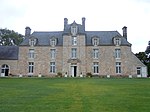
Coscro Castle
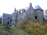
Kerouallan's mansion
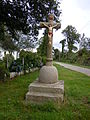
Cross of Le Pou


literature
- Le Patrimoine des Communes du Morbihan. Flohic Editions, Volume 1, Paris 1996, ISBN 2-84234-009-4 , pp. 375-378.
Individual evidence
- ^ Map with the municipalities of the Pays du Roi Morvan
- ↑ Lignol on Cassini.ehess.fr (French)
- ↑ Sights of the community ( Memento of the original from January 13, 2014 in the Internet Archive ) Info: The archive link was inserted automatically and has not yet been checked. Please check the original and archive link according to the instructions and then remove this notice. (French)