Campénéac
|
Campénéac Caunpenyac |
||
|---|---|---|

|
|
|
| region | Brittany | |
| Department | Morbihan | |
| Arrondissement | Pontivy | |
| Canton | Ploërmel | |
| Community association | Ploërmel Communauté | |
| Coordinates | 47 ° 57 ′ N , 2 ° 18 ′ W | |
| height | 46-216 m | |
| surface | 60.57 km 2 | |
| Residents | 1,903 (January 1, 2017) | |
| Population density | 31 inhabitants / km 2 | |
| Post Code | 56800 | |
| INSEE code | 56032 | |
| Website | http://www.campeneac.fr/ | |
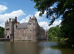
 Castle Château de Trécesson |
||
Campénéac ( Gallo Caunpenyac , Breton Kempenieg ) is a French municipality with 1,903 inhabitants (at January 1, 2017) in the department of Morbihan in the region of Brittany .
geography
Campénéac is located around 49 kilometers northeast of Vannes and 48 kilometers southwest of Rennes on the Oyon River . The place in the northeast of the Morbihan department lies on the border with the Ille-et-Vilaine department and belongs to the Ploërmel Communauté community .
Neighboring municipalities are Tréhorenteuc and Paimpont (Département Ille-et-Vilaine) in the north, Beignon in the east, Augan in the south, Ploërmel in the southwest and west, Gourhel in the west and Loyat in the northwest.
Population development
| year | 1793 | 1856 | 1911 | 1962 | 1968 | 1975 | 1982 | 1990 | 1999 | 2006 | 2012 |
| Residents | 2,150 | 2,314 | 2,071 | 1,446 | 1,399 | 1,356 | 1,305 | 1.406 | 1,464 | 1,659 | 1,882 |
| Sources: Cassini and INSEE | |||||||||||
- Campénéac
Attractions
See: List of Monuments historiques in Campénéac
literature
- Le Patrimoine des Communes du Morbihan. Flohic Editions, Volume 2, Paris 1996, ISBN 2-84234-009-4 , pp. 653-655.
Individual evidence
Web links
Commons : Campénéac - collection of images, videos and audio files


