
Neant-sur-Yvel
|
Neant-sur-Yvel Neant |
||
|---|---|---|
.svg)
|
|
|
| region | Brittany | |
| Department | Morbihan | |
| Arrondissement | Pontivy | |
| Canton | Ploërmel | |
| Community association | Ploërmel Communauté | |
| Coordinates | 48 ° 1 ′ N , 2 ° 20 ′ W | |
| height | 37-150 m | |
| surface | 32.30 km 2 | |
| Residents | 1,087 (January 1, 2017) | |
| Population density | 34 inhabitants / km 2 | |
| Post Code | 56430 | |
| INSEE code | 56145 | |
 Town hall (Mairie) of Néant-sur-Yvel |
||

Néant-sur-Yvel ( Gallo néant , Breton Neant ) is a commune with 1,087 inhabitants (at January 1, 2017) in the Morbihan department in the region of Brittany .
geography
Néant-sur-Yvel is located around 49 kilometers southwest of Rennes in the northeast of the Morbihan department. The municipality lies on the border between the Morbihan and Ille-et-Vilaine departments .
Neighboring municipalities are Mauron in the north and northeast, Paimpont (Ille-et-Vilaine) in the east, Tréhorenteuc in the southeast, Loyat in the south and southwest and Guilliers in the northwest.
Population development
| year | 1793 | 1881 | 1962 | 1968 | 1975 | 1982 | 1990 | 1999 | 2006 | 2012 |
| Residents | 1,480 | 1,845 | 1,076 | 939 | 870 | 835 | 882 | 851 | 950 | 994 |
| Sources: Cassini and INSEE | ||||||||||
language
In the early Middle Ages the area was settled by Bretons and their colloquial language was everyday language. During the second wave of retreat of the Breton language in the late Middle Ages (between 1200 and 1500), the language changed to Gallo . This dialect of French has now almost died out and the population now speaks French.
Architectural monuments
See: List of Monuments historiques in Néant-sur-Yvel

Saint-Pierre village church
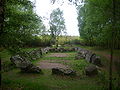
Jardin aux moines

Le Bois de la Roche castle

Cross in the church square of Néant-sur-Yvel


literature
- Le Patrimoine des Communes du Morbihan. Flohic Editions, Volume 2, Paris 1996, ISBN 2-84234-009-4 , pp. 596-599.