Concoret
|
Concoret Konkored |
||
|---|---|---|

|
|
|
| region | Brittany | |
| Department | Morbihan | |
| Arrondissement | Pontivy | |
| Canton | Ploërmel | |
| Community association | Ploërmel Communauté | |
| Coordinates | 48 ° 4 ′ N , 2 ° 12 ′ W | |
| height | 66-133 m | |
| surface | 15.76 km 2 | |
| Residents | 734 (January 1, 2017) | |
| Population density | 47 inhabitants / km 2 | |
| Post Code | 56430 | |
| INSEE code | 56043 | |
| Website | http://concoret.fr/ | |
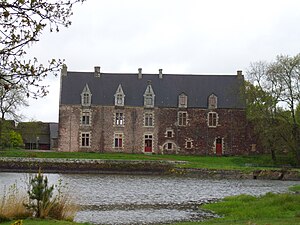
 Comper Castle |
||
Concoret ( Breton Konkored ) is a French municipality with 734 inhabitants (at January 1, 2017) in the department of Morbihan in the region of Brittany . It belongs to the arrondissement of Pontivy and the canton of Ploërmel .
geography
The community is located on the northwestern edge of the 9,000 hectare Forêt de Paimpont , the rest of the legendary Brocéliande , about 20 kilometers northeast of Ploërmel and about 40 kilometers west of Rennes . To the north, east and south, the municipality of Concoret borders on the Ille-et-Vilaine department .
Population development
| year | 1962 | 1968 | 1975 | 1982 | 1990 | 1999 | 2008 |
| Residents | 614 | 683 | 731 | 668 | 626 | 645 | 777 |
Attractions
- Guillotin oak (approx. 600 years old)
- Comper Castle, Monument historique
literature
- Le Patrimoine des Communes du Morbihan. Flohic Editions, Volume 2, Paris 1996, ISBN 2-84234-009-4 , pp. 590-591.
Individual evidence
Web links
Commons : Concoret - collection of images, videos and audio files

