
Malguénac
|
Malguénac Malgeneg |
||
|---|---|---|
|
||
| region | Brittany | |
| Department | Morbihan | |
| Arrondissement | Pontivy | |
| Canton | Gourin | |
| Community association | Pontivy Communauté | |
| Coordinates | 48 ° 5 ′ N , 3 ° 3 ′ W | |
| height | 73–222 m | |
| surface | 38.45 km 2 | |
| Residents | 1,843 (January 1, 2017) | |
| Population density | 48 inhabitants / km 2 | |
| Post Code | 56300 | |
| INSEE code | 56125 | |
| Website | http://www.malguenac.fr/ | |

Malguénac ( Breton : Malgeneg ) is a French municipality with 1843 inhabitants (at January 1, 2017) in the department of Morbihan in the region of Brittany . It belongs to the community association Pontivy Communauté .
geography
Malguénac is located in the north of the Morbihan department and belongs to the Pays de Pontivy.
Neighboring communities are Cléguérec in the north, Pontivy in the east, Le Sourn in the south-east, Guern in the south and south-west and Séglien in the north-west.
Due to its location west of the city of Pontivy, the place is close to roads for national traffic. North of Malguénac, the D782 runs from Pontivy to Rosporden . The most important road connections are the D700 / D768 (formerly Route nationale 168 ), which passes several kilometers east of the municipality, the N164 in the north and the N24 further south.
The most important bodies of water are the Bonne Chère , Le Frétu , Germaude , La Pierre and Ker Jéhanno streams . These also partially form the municipal boundary. There are also several ponds in the municipality.
Population development
| year | 1962 | 1968 | 1975 | 1982 | 1990 | 1999 | 2006 |
| Residents | 1,214 | 1,076 | 1,194 | 1,419 | 1,631 | 1,657 | 1,726 |
history
Historically, the municipality belongs to the Breton region of Bro Gwened (French: Vannetais) and within this region to the Bro Pondi (French: Pays de Pontivy) area and shares its history. Malguénac has belonged to the canton of Cléguérec since 1793. Parts of the former municipality were separated from Malguénac when the new municipality Le Sourn was formed in 1869.
Attractions
See also: List of Monuments historiques in Malguénac
- Village church of Saint-Pierre et Saint-Paul from the 15th century, restored in the 19th century
- Saint-Patern chapel from the 15th and 18th centuries
- Saint-Gildas chapel in Gueltas from the 15th and 16th centuries
- Saint-Etienne chapel
- Notre-Dame-du-Moustoir chapel from the 15th century
- Saint-Bédic (also Saint-Pédic ) chapel from the 14th and 17th centuries
- Calvary on the abandoned old cemetery
- Castles of Moustoirlan (15th century) and Lesturgant (1885)
- Manor houses of Kerlois (17th century), Guily (17th century) and Kera-Mour (1987/1988, made of stone from historical buildings)
- Fountain of Le Moustoir and Saint-Etienne
- numerous old mills (in Kermor, Bonne-Chère, Roch, Le Poulglas, Lesturgant, Huen, Saint-Nizon and Kerivalan)
- Menhirs of Maneven
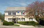
Mayor's office in Malguénac

Village church of Saint-Pierre et Saint-Paul in Malguénac
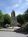
Memorial to the deceased


literature
- Le Patrimoine des Communes du Morbihan. Flohic Editions, Volume 1, Paris 1996, ISBN 2-84234-009-4 , pp. 179-185.
Individual evidence
- ↑ Official website of the CC du Pays de PontivyCC (French)
- ↑ Map with the municipalities of the Pays de Pontivy ( Memento of the original from January 11, 2012 in the Internet Archive ) Info: The archive link has been inserted automatically and has not yet been checked. Please check the original and archive link according to the instructions and then remove this notice.
- ↑ Malguénac on Cassini.ehess.fr (French)
- ↑ Sights ( Memento of the original from March 4, 2016 in the Internet Archive ) Info: The archive link was automatically inserted and not yet checked. Please check the original and archive link according to the instructions and then remove this notice.
- ↑ Sights of the community ( Memento of the original from January 14, 2014 in the Internet Archive ) Info: The archive link was inserted automatically and has not yet been checked. Please check the original and archive link according to the instructions and then remove this notice. (French)