
Montertelot
|
Montertelot Montertelo |
||
|---|---|---|
|
||
| region | Brittany | |
| Department | Morbihan | |
| Arrondissement | Pontivy | |
| Canton | Ploërmel | |
| Community association | Ploërmel Communauté | |
| Coordinates | 47 ° 53 ′ N , 2 ° 25 ′ W | |
| height | 19-100 m | |
| surface | 2.64 km 2 | |
| Residents | 355 (January 1, 2017) | |
| Population density | 134 inhabitants / km 2 | |
| Post Code | 56800 | |
| INSEE code | 56139 | |
.JPG) Montertelot Town Hall |
||

Montertelot ( Gallo Montertelo , Breton Mousterdelav ) is a French municipality with 355 inhabitants (at January 1, 2017) in the department of Morbihan in the region of Brittany .
geography
Montertelot is located about 36 kilometers northeast of Vannes in the northeast of the Morbihan department and belongs to the Ploërmel Communauté community .
Neighboring communities are Ploërmel in the north, Val d'Oust with La Chapelle-Caro in the east and south and Le Roc-Saint-André in the west.
Population development
| year | 1793 | 1821 | 1906 | 1926 | 1962 | 1968 | 1975 | 1982 | 1990 | 1999 | 2006 | 2012 |
| Residents | 210 | 265 | 231 | 171 | 213 | 227 | 242 | 268 | 279 | 255 | 322 | 366 |
| Sources: Cassini and INSEE | ||||||||||||
Attractions
See: List of Monuments historiques in Montertelot

Calvaire in Montertelot

Source Saint-Laur

Cross in Montertelot
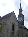
Saint-Laur village church

.jpg)

.JPG)
literature
- Le Patrimoine des Communes du Morbihan. Flohic Editions, Volume 2, Paris 1996, ISBN 2-84234-009-4 , p. 658.
language
In the early Middle Ages the area was settled by Bretons and their colloquial language was everyday language. During the second wave of retreat of the Breton language in the late Middle Ages (between 1200 and 1500), the language changed to Gallo . This dialect of French has now almost died out and the population now speaks French.