
Langonnet
|
Langonnet Langoned |
||
|---|---|---|
.svg)
|
|
|
| region | Brittany | |
| Department | Morbihan | |
| Arrondissement | Pontivy | |
| Canton | Gourin | |
| Community association | Roi Morvan Community | |
| Coordinates | 48 ° 6 ′ N , 3 ° 30 ′ W | |
| height | 104-292 m | |
| surface | 85.40 km 2 | |
| Residents | 1,757 (January 1, 2017) | |
| Population density | 21 inhabitants / km 2 | |
| Post Code | 56630 | |
| INSEE code | 56100 | |
| Website | http://www.langonnet.fr/ | |
 West facade of the village church of Saint-Pierre-et-Saint-Paul |
||

Langonnet ( Breton : Langoned ) is a French municipality with 1757 inhabitants (at January 1, 2017) in the department of Morbihan in the region of Brittany . It belongs to the community association Roi Morvan Communauté .
geography
Langonnet is located in the north-west of the Morbihan department on the border with the Côtes-d'Armor department and belongs to the Pays du roi Morvan.
Neighboring municipalities are the municipalities of Tréogan , Plévin and Paule in the north and Glomel in the northeast, Plouray in the east, Priziac in the southeast, Le Faouët in the south, and Le Saint and Gourin in the west, in the Côtes-d'Armor department .
The place itself is on the D121. The most important road connections are the D769 from Saint-Pol-de-Léon to Lorient , which passes west of the town, and the N164 in the north.
The most important bodies of water are the Ellé and Langonnet rivers and the Le Moulin du Doc stream . The Ellé and the Moulin du Doc also partially form the municipal boundary. There is also a reservoir in the municipality.
Population development
| year | 1962 | 1968 | 1975 | 1982 | 1990 | 1999 | 2006 |
| Residents | 3,083 | 2,791 | 2,373 | 2,106 | 2.005 | 1.918 | 1,908 |
history
The municipality historically belongs to the Breton region of Kernev (French. Cornouaille ) and within this region to the area Bro Chtou (French. Chtou) and shares its history. From 1793 until its dissolution in 1801, Langonnet was the capital of its own canton. Since then it has been assigned to the Canton of Gourin.
Attractions
See also: List of Monuments historiques in Langonnet
- Village church of Saint-Pierre et Saint-Paul from the 12th-16th centuries century
- Trinity Church (de la Trinité), church of the Abbot of Langonnet, from the 16th century
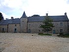
- Notre-Dame-de-Langonnet Cistercian Abbey from 1136
- Chapel Sainte-Magdeleine (also Sainte-Madeleine ) in La Magdeleine from the 16th century
- Chapel Notre-Dame-de-Pitié (also new chapel or Locmaria) in Restangoas-Guen of 1661
- Saint-Adrien Chapel in Saint-Brendan from the 16th century
- Saint-Gwénolé (also Saint-Guénolé ) chapel from the 16th and 17th centuries
- Calvary near the village church
- Fountain de la Trinité from 1696
- Kermain mansion from the 16th and 17th centuries
- Mansion Bourlogot , formerly a convent
- Gouléis mansion (also Gouleiz or Goule) from the 17th century
- Manor or Keraudrénic Castle
- Menhir from Bodéro
- Remains of the Roman road Carlaix-Hennebont
- Barrow of Minez Collober in Kermain

Mayor's office and post office in Langonnet
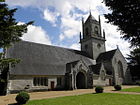
Village church of Saint-Pierre et Saint-Paul
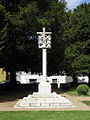
Calvary in the village cemetery

Notre-Dame-de-Langonnet Abbey

Langonnet hoard in the Vannes Museum

Trinity Church (Eglise de la Trinité)
Kermain mansion

The river Ellé on the municipal boundary

_%C3%89glise_02.JPG)
_Calvaire_du_cimeti%C3%A8re_01.JPG)


_%C3%89glise_01.JPG)


literature
- Le Patrimoine des Communes du Morbihan. Flohic Editions, Volume 1, Paris 1996, ISBN 2-84234-009-4 , pp. 305-312.
Individual evidence
- ^ Map with the municipalities of the Pays du Roi Morvan
- ^ Langonnet on Cassini.ehess.fr (French)
- ↑ Sights
- ↑ Sights of the community ( Memento of the original from January 15, 2014 in the Internet Archive ) Info: The archive link was inserted automatically and has not yet been checked. Please check the original and archive link according to the instructions and then remove this notice. (French)