
Erbach (Odenwald)
| coat of arms | Germany map | |
|---|---|---|
.svg)
|
Coordinates: 49 ° 39 ' N , 9 ° 0' E |
|
| Basic data | ||
| State : | Hesse | |
| Administrative region : | Darmstadt | |
| County : | Odenwaldkreis | |
| Height : | 210 m above sea level NHN | |
| Area : | 61.53 km 2 | |
| Residents: | 13,697 (Dec. 31, 2019) | |
| Population density : | 223 inhabitants per km 2 | |
| Postcodes : | 64711, 64743 (Marbach) |
|
| Primaries : | 06062, 06061 (Ernsbach) | |
| License plate : | ERB | |
| Community key : | 06 4 37 006 | |
| LOCODE : | DE ERB | |
| City structure: | 13 districts (including the core city) in 11 local districts | |
City administration address : |
Neckarstrasse 3 64711 Erbach |
|
| Website : | ||
| Mayor : | Peter Traub (independent) | |
| Location of the city of Erbach in the Odenwald district | ||
  |
||


Erbach is the district town of the Odenwaldkreis in southern Hesse .
geography
Geographical location
The urban area of Erbach is located in the red sandstone area of the Odenwald . Here it occupies the southern upper end of the valley range of the Mümling, which runs in a south-north direction, and extends in the west and east up to the eight kilometers distant heights that the Mümlingtal from the Mossau valley in one direction and from the Mudtal and Ittertal in the other way. The urban area stretches along the Mümling from the Michelstädter outskirts in the north to seven and a half kilometers to the Marbach and the Himbachel in the south.
In the north, directly on the Mümling, the core town of Erbach is the first, followed up the valley by Lauerbach, Schönnen and Ebersberg. In the left western side valleys in the far north are the hamlet of Roßbach in the headwaters of the stream of the same name, which reaches the city center through the Brudergrund . South of Roßbach follow one another after Elsbach, Günterfürst and Haisterbach. The development of Dorf-Erbach, which is located on the Erdbach , is seamlessly connected to the east of the city center . Further east on the source brooks of the Erdbach, surrounded by forest, are Ernsbach and Erbuch. Erlenbach connects to the southeastern end of the city center. The furthest away from the city center and the highest at 515 m is the Waldhufendorf Bullau, which lies behind the watershed to the Euterbach and is therefore the only Erbach district that does not drain to the Mümling, but to the Neckar . In the Bullau district, on the one hand, there are the hamlets of Bullauer Eutergrund on the state border with Bavaria and, with the Kohlwald ( 560.4 m above sea level ), the highest point in the Odenwald district. The core town of Erbach is at its lowest at 210 m above sea level. NN and the banks of the Mümling on the city limits to Michelstadt at 200 m above sea level. NN .
Neighboring communities
Erbach borders in the north on the city of Michelstadt , in the east on the Markt Kirchzell ( district Miltenberg in Bavaria ), in the south on the city of Oberzent and in the west on the community Mossautal (both in the Odenwaldkreis).
The cities of Erbach and Michelstadt, with their centers only two kilometers apart, have long since grown together structurally and with a combined population of almost 30,000 form the economic focus of the Odenwald district. A merger of the two cities planned for 2009 was prevented by a referendum in November 2007. Both sides are now looking for other ways of deepening communal cooperation.
City structure
The district town of Erbach consists of the following districts :
- Bullau with the hamlet of Bullauer Eutergrund (common district )
- Dorf-Erbach with the hamlet Habermannskreuz (common local district)
- Ebersberg (own local district)
- Elsbach (own local district)
- Erlenbach (own local district)
- Ernsbach (part of the Ernsbach-Erbuch district )
- Core town Erbach (no district was established for the core town)
- Erbuch (part of the Ernsbach-Erbuch district )
- Günterfürst (own local district)
- Haisterbach with the hamlet of Marbach (common district)
- Lauerbach (own local district)
- Weiler Roßbach (organizationally as part of the core city without local district)
- Schönnen (own local district)
history
The place was first mentioned in a document in 1095 in the Lorsch Codex under the name "Ertbach". In 1180 there the first owner in the Valley of Mümling built a moated castle , the remains of which can be admired today. The place was surrounded by a city wall together with the castle and since then the residence city of the Counts of Erbach-Erbach . There has been a town hall since 1545 and in 1560 Erbach received city rights together with the coat of arms and seal.
The city's history experienced a decisive turning point through the Thirty Years' War (1618 to 1648) and the associated plague epidemics . Further wars and freak weather were not exactly conducive to further urban development. In 1750 the town church replaced the old town chapel from 1370. The introduction of ivory carving in 1783 is due to the last imperial count Franz I.
After mediatization in 1806, the imperial county of Erbach , which had belonged to the Franconian imperial circle since 1500 , came into the possession of the Grand Duchy of Hesse and then became the district town of Erbach.
Despite steady growth since 1945, Erbach has largely been able to preserve its historical legacy. The German Ivory Museum Erbach has existed since 1966 , the only special museum of its kind for ivory art in Europe.
In the area of the orangery and the palace gardens, a citizens' initiative was able to prevent their demolition and the construction of a high-rise hotel instead of the orangery in the 1970s.
The monument to Count Franz I - the last ruling count - which fell from its pedestal on July 28, 2005 and was broken in the process, was repaired and rebuilt with the support of two Darmstadt artists and citizens of Erbach. The restoration was financed by grants from the State Office for Monument Preservation and donations.
A merger with Michelstadt was rejected in November 2007 with 52 percent of the vote in a referendum.
Until 2011, the city had the title of state-recognized health resort .
Historical forms of names
Historically documented mentions of the place are:
- Ertbach (1095)
- Erpach (1327)
- Erpbach (1340)
- Ertpach (around 1345)
- Erppach (1354)
- Erpach (1462)
- Erbach (1581)
Incorporations
As part of the Hessian municipal area reform , ten previously independent municipalities were assigned to the Erbach urban area from December 31, 1971 to August 1, 1972 .
| district | surface | Incorporation | Ew. 1961 |
Ew. 1970 |
Ew. 2012 |
|---|---|---|---|---|---|
| Bullau | 9.98 km² | February 1, 1972 | 321 | 300 | 415 |
| Village Erbach | 4.08 km² | February 1, 1972 | 427 | 601 | 1693 |
| Ebersberg | 3.59 km² | December 31, 1971 | 206 | 219 | 265 |
| Elsbach | 3.01 km² | December 31, 1971 | 64 | 72 | 117 |
| Erbach | 10.89 km² | - | 5610 | 7004 | 8886 |
| Erlenbach | 4.28 km² | December 31, 1971 | 345 | 320 | 913 |
| Ernsbach-Erbuch | 9.08 km² | December 31, 1971 | 163 | 165 | 241 |
| Günterfürst | 4.08 km² | December 31, 1971 | 374 | 462 | 772 |
| Haisterbach | 5.88 km² | December 31, 1971 | 219 | 239 | 438 |
| Lauerbach | 2.27 km² | December 31, 1971 | 336 | 430 | 416 |
| Beauty | 5.53 km² | August 1, 1972 | 263 | 262 | 334 |
Population development
Source: Historical local dictionary
- 1623: 11 citizens pay homage to the Archbishop of Mainz
- 1961: 4297 Protestant (= 76.60%), 1118 Catholic (= 19.93%) inhabitants
| Erbach: Population from 1829 to 2015 | ||||
|---|---|---|---|---|
| year | Residents | |||
| 1829 | 1.934 | |||
| 1834 | 2.136 | |||
| 1840 | 2,256 | |||
| 1846 | 2,401 | |||
| 1852 | 2,391 | |||
| 1858 | 2,285 | |||
| 1864 | 2,427 | |||
| 1871 | 2,592 | |||
| 1875 | 2,721 | |||
| 1885 | 2,967 | |||
| 1895 | 2,859 | |||
| 1905 | 3,039 | |||
| 1910 | 3,219 | |||
| 1925 | 3,466 | |||
| 1939 | 3,933 | |||
| 1946 | 5,099 | |||
| 1950 | 5,529 | |||
| 1956 | 5,360 | |||
| 1961 | 5,610 | |||
| 1967 | 6,195 | |||
| 1970 | 7.004 | |||
| 1972 | 10,231 | |||
| 1976 | 10,398 | |||
| 1984 | 10,734 | |||
| 1992 | 11,821 | |||
| 2000 | 13,100 | |||
| 2010 | 13,341 | |||
| 2015 | 13,400 | |||
| Data source: Historical municipality register for Hesse: The population of the municipalities from 1834 to 1967. Wiesbaden: Hessisches Statistisches Landesamt, 1968. Further sources:; 1972 :; 1976 :; 1984 :; 1992 :; 2000, 2015 :; 2010: From 1972 including the towns incorporated into Hesse as part of the regional reform . | ||||
politics
City Council
The local elections on March 6, 2016 produced the following results, compared to previous local elections:
| Parties and constituencies |
% 2016 |
Seats 2016 |
% 2011 |
Seats 2011 |
% 2006 |
Seats 2006 |
% 2001 |
Seats 2001 |
||
|---|---|---|---|---|---|---|---|---|---|---|
| SPD | Social Democratic Party of Germany | 31.6 | 10 | 30.7 | 9 | 37.9 | 12 | 35.4 | 13 | |
| CDU | Christian Democratic Union of Germany | 24.3 | 8th | 27.0 | 8th | 36.7 | 11 | 39.3 | 14th | |
| GREEN | Alliance 90 / The Greens | 9.7 | 3 | 18.1 | 6th | 7.9 | 3 | 7.4 | 3 | |
| ÜWG | Non-partisan community of voters of the district town of Erbach eV | 27.2 | 8th | 14.8 | 5 | 13.5 | 4th | 17.9 | 7th | |
| FDP | Free Democratic Party | 7.2 | 2 | 5.7 | 2 | 4.0 | 1 | - | - | |
| REP | The Republicans | - | - | 3.8 | 1 | - | - | - | - | |
| total | 100.0 | 31 | 100.0 | 31 | 100.0 | 31 | 100.0 | 37 | ||
| Voter turnout in% | 45.3 | 46.0 | 52.4 | 55.4 | ||||||
mayor
In the election on March 11, 2012, Martina Köllner (SPD) and Christa Weyrauch (Greens) competed against incumbent Buschmann (CDU). Since none of the candidates could achieve an absolute majority, a runoff election between Buschmann and Köllner was scheduled, which Buschmann won with 52.7 percent. In the subsequent election on March 4, 2018, Peter Traub prevailed in the first ballot with 60.0% against incumbent Buschmann (32.2%) and Andreas Wagner (7.7%). Traub is a member of the FDP, but ran as an independent candidate and was supported by the SPD and the ÜWG voter association. He took office in July.
| Term of office | Surname | Political party |
|---|---|---|
| 1919-1933 | Wilhelm Dengler | SPD |
| 1945 | Wilhelm Dengler (inserted) | SPD |
| 1945-1960 | Leonhard Volk | SPD |
| 1960-1987 | Werner Borchers | ÜWG |
| 1988-1994 | Dieter Haver | CDU |
| 1994-2000 | Uwe Hartmann | SPD |
| 2000-2018 | Harald Buschmann | CDU |
| from July 2018 | Peter Traub | FDP |
coat of arms
Blazon : In red, a blue sloping bar with three red stars .
In 1560, Count Eberhard von Erbach gave his city of Erbach this coat of arms, which is described as follows : a red scolding, thus a bare stream or river and in such a stream three red stars . The seal procured at that time with the inscription: STAT ERBACH contains the awarded coat of arms : an (apparent) sloping bar with three stars, but not in the shield , but in the seal field. In 1573 the city seals with the SIGILLVM OPPIDI ERPACH, known as the city secret, which shows the same image in the shield, and a coat of arms from 1593 on the town hall shows this image. The seal of the CITY OF ERBACH, probably from the 17th century, then abandons the sloping bar in favor of a simple (horizontal) wavy bar, as could easily be read from the oldest seal if the seal was incorrectly held. In this form, the SEAL OF THE MAYOR OF ERBACH of the late 18th century also leads the wavy bar with stars, but again without a shield, freely in the seal field, as does the seal of the GR (OSSDUCOGLICH) HESS (ISCHEN) MAYOR OF ERBACH of the early 19th century .
Accordingly, it appears with Clemens Kissel , while Otto Hupp, in his opinion, brings "improved" colors, after it had already been pointed out in the new Siebmacher (IV. Section 5 ff.) That the river should be silver, not blue. However, this view only applies if the middle section of the coat of arms is not interpreted as a stream or river, as intended in the original blazon, and therefore as a " common figure " that does not require a color-metal contrast, but rather as a simple herald figure; however, it does not recognize a " wavy bar " as such.
It is a talking coat of arms , as its three stars come from the Graflich-Erbachischen coat of arms.
Town twinning
Erbach has city partnerships with the following cities:
- Le Pont-de-Beauvoisin (Isère) and Le Pont-de-Beauvoisin (Savoie) in France (since 1963)
- Königsee in Thuringia (since 1990)
- Ansião in Portugal (since 1992)
- Jičín in the Czech Republic (since 1993)
religion
- Parishes of the Evangelical Church in Hesse and Nassau in Erbach and Schöllenbach-Bullau
- Roman Catholic parish of St. Sophia of the Diocese of Mainz
- Christian assembly
- Evangelical Free Congregation Habitat
- Community of Jehovah's Witnesses
- Mission Alliance Church
- Independent Evangelical Lutheran Castle Community
Culture and sights
Buildings
In the core city and the other districts there is a considerable number of cultural monuments that are well worth seeing .

Monument to Count Franz I in front of the castle

District Office of the Odenwaldkreis
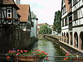
Half-timbered houses on the Mümling
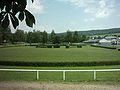
Trotting track


Castle of the Counts of Erbach-Erbach

The old castle of the Counts of Erbach was expanded into a palace in the 18th century. The collections of the castle of Count Franz I (1754–1823) housed there are significant, and their original presentation has been preserved to this day.
The German Ivory Museum, founded in 1966, has also been housed there since 2016 , which was previously located in a building with the town hall away from the historic city center.
The late Baroque orangery with the pleasure garden also belongs to the palace ensemble.
Evangelical Lutheran town church
The Protestant town church, which was completed in 1750 and has over a thousand seats, is mentioned in the Dehio as "the most important Protestant church in southern Hesse". What is striking is the rare transept layout of the interior, which is otherwise more likely to be found in Protestant-Reformed churches. The motif windows are foundations for community anniversary in 1897. From 1899 comes one of the few still preserved in its original state Sauer - organs .
Stadtel
To the north of the castle is the medieval core of Erbach. The Burgmanns' courtyards have been traceable here since the 14th century, parts of which have been preserved in the Städtel area to this day . Most important in terms of architectural history is the so-called temple house , seat of the Echter family (Städtel 15a / 21). The so-called Habermannsburg (Städtel 26), seat of the von Habern family , adjoins the outbuildings of the castle to the northwest. The Burgmannenhaus Pavey forms the north-western end of the castle settlement and leaned against the city fortifications. It has housed the Protestant kindergarten since 1953.


Chapel "In Need of God"
In the Brudergrund , a valley floor two kilometers west of the city, are the remains of the foundation wall of the Chapel Zur Not Gottes , a chapel that was built around 1200 with a surrounding cemetery that was in use until 1598.
Erdbach slip
A geological peculiarity is the complete seepage of the Erdbach within the district of Dorf-Erbach. The Erdbach re-emerges from Stockheim , a district of Michelstadt. There are several places where the stream drains away. Measurements with color additives showed that the water needed up to 23 hours to travel through the infiltration area. This suggests a pronounced system of dikes with lakes, which it has been possible to explore at around 400 meters so far. The Erdbach cave system, as one of the largest karst phenomena in the southern Hesse region, forms an impressive and rare geological natural monument . (→ Main article: Erdbach (Mümling) )
Regular events
Wiesenmarkt / Eulbacher Markt
The Erbacher Wiesenmarkt was called Eulbacher Markt or Eulbacher Wiesen (cattle) market until the 1960s because it was originally held in Eulbach (since 1972 part of Michelstadt ) as a regionally very important cattle, horse and farmer's market. As early as 1824, the market had been relocated to an open space on what was then the northern outskirts of Erbach.
The Schützenhaus is at the entrance to the Wiesenmarkt . This is where the democratic revolutionaries met in 1848, and in the same year the historic Odenwald People's Assembly took place in the neighboring market area, under the leadership of the Michelstädter revolutionary and lawyer Ludwig Bogen .
Until around 1960, the cattle and horse market with accompanying horse races and other equestrian sports was the main component of the Eulbacher Markt. The Erbacher Trabrennbahn was part of the market area.
Erbach Castle Christmas
The Erbacher Schlossweihnacht ( Christmas market ) takes place on the Advent weekends in November and December from Friday to Sunday . The market extends from the castle courtyard via the market square to the historic old town, the Städtel .
Erbach-Michelstädter theater summer
Annual open-air theater event with a large number of regional amateur actors, directed and organized by theater educator and director Alexander Kaffenberger. Alternating with the neighboring Michelstadt, the palace courtyard in Erbach becomes a theater stage every two years.
Economy and Infrastructure
Franz I, the last ruling count, introduced ivory carving in 1783 . Hence the city is nicknamed Ivory City . Many artists then settled. Her works and their work are thematized by the Ivory Museum, which opened in 1966 .
traffic
Erbach is on the B 45 , B 47 . A B45 bypass that has been planned since the 1970s has again been included in the investment planning of the State of Hesse.
With the rail Erbach is the Odenwaldbahn of ( Frankfurt - Darmstadt / Hanau -Erbach- Eberbach connected). There are two stops: the breakpoint Erbach (. Odenw) North and Erbach (. Odenw) station The stations are in the passenger of trains of the railway company VIAS GmbH within the transport association Rhein-Main Transport Association approached (RMV).
Bike trails
The following cycle paths lead along the Mümling :
- The 225 km long 3-country cycle route leads as a circular route through the triangle of Hesse, Baden-Württemberg and Bavaria. The route explores the Odenwald along the Mümling, Neckar and Main rivers.
- The Mümlingtalradweg R1 is part of the three-country cycle path and connects Hirschhorn am Neckar with Obernburg am Main for over 75 kilometers.
- The Hessian long-distance cycle route R4 begins in Hirschhorn am Neckar and runs with a total length of 385 kilometers from south to north through Hesse, along from Mümling, Nidda and Schwalm to Bad Karlshafen an der Weser.
Established businesses
- Robert Bosch GmbH , Erbach plant, Electric Drives and Controls division
- Rowenta , Erbach plant (manufacture of irons)
- Koziol , plastic items
education
- School on the stairway ( elementary school )
- Astrid Lindgren School (primary school)
- School at the Sportpark ( integrated comprehensive school for 5th to 10th grade)
- School at the Drachenfeld (special school)
Authorities
Erbach is the seat of the district office of the Odenwaldkreis . Erbach is the southernmost area in the Odenwald with the Erbach Police Department . The employment agency also has a branch in the city. The city administration in Neckarstrasse offers a common point of contact for various matters in the citizen service office.
Personalities
sons and daughters of the town
see also: Erbach (noble family)
- Johann Philipp Preuß (1605 - around 1687), leading sculptor in Würzburg
- Christian Wilhelm Karl Kehrer (1775–1869), animal and landscape painter, archivist
- Johann Friedrich Knapp (1776–1848), Member of Parliament and President of the 2nd Chamber of the Estates of the Grand Duchy of Hesse
- Moritz Friedrich Illig (1777–1845), watchmaker and inventor in paper production
- Ferdinand Karl Schweikart (1780–1857), lawyer and mathematician
- Carl zu Erbach-Erbach (1782–1832), registrar
- Friedrich zu Erbach-Erbach (1785–1854), major general
- Georg Heinrich von Bezzenberger (1795–1866), President of the Württemberg Upper Tribunal
- Georg Klett (1797–1855), doctor
- Greta Bickelhaupt (1865–1919) educator, local poet and writer
- Louis Brunner (1865–1950), trade unionist and politician (SPD), MdR
- Otto Heinrich Engel (1866–1949), painter, one of the pioneers of avant-garde modern painting in Germany
- Heinrich List (1882–1942), farmer from Ernsbach, murdered in 1942 in the Dachau concentration camp ; with his wife Marie List as Righteous among the Nations honored
- Ferdinand Preiss (1882–1943), sculptor, leading ivory carver of Art Deco.
- Jakob Trumpfheller (1887–1975), politician (SPD), MdL
- Albrecht Glenz (1907–1990), sculptor and lecturer
- Heinz-Otto Müller-Erbach (1921–1984), painter
- Paul Heinrich Nodnagel (1928–2009), modern painter
- Friedrich Battenberg (* 1946), German lawyer, historian and archivist
- Verena Countess von Roedern (* 1955), diplomat
- Ulrich Stroth (* 1957), physicist
- Gerd Gruber (* 1960), orthopedic surgeon and trauma surgeon
- Norbert Busè (* 1963), documentary filmmaker and director
- Dagmar Sacher (* 1966), judge at the Federal Court of Justice
- Bettina Meiselbach (* 1969), cookbook and non-fiction author
- Oka Nikolov (* 1974), Macedonian football goalkeeper and coach
- Jessica Schwarz (* 1977), German actress and presenter
- Katja Benrath (* 1979), German actress and director
- Timo Boll (* 1981), table tennis professional
- Meike Weber (* 1987), soccer player
- Jonas Rutsch (* 1998), racing cyclist
Personalities associated with the city
- Ludwig Gottfried Klein (1716–1756), physician and councilor and personal physician to the Counts of Erbach
- Johann Wilhelm Wendt (1747–1815), master builder for Count Franz I. zu Erbach-Erbach and silhouette cutter
- Wendelin Brohm (1887–1980), local politician of the USP / SPD, AWO district chairman, holder of the Federal Cross of Merit, holder of the bronze honorary plaque of the Erbach district
- Rudolf Hagelstange (1912–1984), writer
- Walter Masing (1915–2004), physicist and entrepreneur
- Katrin Dörre-Heinig (* 1961), long-distance runner
- Serap Çileli (* 1966), book author
- Corinna Harder (* 1970), author
literature
- Wolfram Becher: Michelstadt and Erbach. Two romantic cities in the Odenwald. Amorbach 1980
- Literature about Erbach in the Hessian Bibliography
Web links
- Website of the city of Erbach
- Erbach, municipality, Odenwaldkreis. Historical local dictionary for Hessen. In: Landesgeschichtliches Informationssystem Hessen (LAGIS).
- Erbach, Odenwaldkreis. Historical local dictionary for Hessen. In: Landesgeschichtliches Informationssystem Hessen (LAGIS).
- Research for cultural monuments in Erbach (126 data sets)
- Link catalog on the subject of Erbach at curlie.org (formerly DMOZ )
Individual evidence
- ↑ Hessian State Statistical Office: Population status on December 31, 2019 (districts and urban districts as well as municipalities, population figures based on the 2011 census) ( help ).
- ↑ a b City district website of the city of Erbach, accessed on July 28, 2017
- ^ Hessischer Rundfunk November 11, 2007 ( Memento from May 21, 2011 in the Internet Archive )
- ↑ Minst, Karl Josef [transl.]: Lorscher Codex (Volume 1), Certificate 141, October 27, 1095 - Reg. 3628. In: Heidelberger historical stocks - digital. Heidelberg University Library, p. 194 ff. , Accessed on February 5, 2016 .
- ↑ echo online from July 19, 2016: An overthrow of a positive kind. Graf-Franz-Fest. The celebration around the statue, which was restored in 2006, helps many citizens
- ^ Frankfurter Allgemeine Zeitung of November 12, 2007: Population rejects city merger in the Odenwald
- ↑ 77th meeting of the specialist committee for health resorts, recreation places and healing wells in Hesse on November 17, 2011 . In: State pointer for the state of Hesse . No. 7 , 2012, ISSN 0724-7885 , p. 221 .
- ↑ a b c Erbach, Odenwaldkreis. Historical local lexicon for Hesse (as of July 8, 2014). In: Landesgeschichtliches Informationssystem Hessen (LAGIS). Hessian State Office for Historical Cultural Studies (HLGL), accessed on July 10, 2014 .
- ^ Federal Statistical Office (ed.): Historical municipality directory for the Federal Republic of Germany. Name, border and key number changes in municipalities, counties and administrative districts from May 27, 1970 to December 31, 1982 . W. Kohlhammer GmbH, Stuttgart and Mainz 1983, ISBN 3-17-003263-1 , p. 358 and 359 .
- ↑ Population statistics of the city of Erbach: 2012 ( Memento from October 31, 2012 in the Internet Archive )
- ↑ Law on the reorganization of the district of Erbach (GVBl. II 330–16) of July 11, 1972 . In: The Hessian Minister of the Interior (ed.): Law and Ordinance Gazette for the State of Hesse . 1972 No. 17 , p. 224 , § 5 ( online at the information system of the Hessian state parliament [PDF; 1,2 MB ]).
- ^ Local elections 1972; Relevant population of the municipalities on August 4, 1972 . In: The Hessian Minister of the Interior (ed.): State Gazette for the State of Hesse. 1972 No. 33 , p. 1424 , point 1025 ( online at the information system of the Hessian state parliament [PDF; 5.9 MB ]).
- ↑ Local elections 1977; Relevant population of the municipalities (item 1668) from December 15, 1976 . In: The Hessian Minister of the Interior (ed.): State Gazette for the State of Hesse. 1976 No. 52 , p. 2283 ( online at the information system of the Hessian state parliament [PDF; 10.3 MB ]).
- ^ Local elections 1985; Relevant population of the municipalities as of October 30, 1984 . In: The Hessian Minister of the Interior (ed.): State Gazette for the State of Hesse. 1984 No. 46 , p. 2175 , point 1104 ( online at the information system of the Hessian state parliament [PDF; 5.5 MB ]).
- ↑ local elections 1993; Relevant population of the municipalities as of October 21, 1992 . In: The Hessian Minister of the Interior (ed.): State Gazette for the State of Hesse. 1992 No. 44 , p. 2766 , point 935 ( online at the information system of the Hessian state parliament [PDF; 6.1 MB ]).
- ^ Municipal data sheet : Erbach. (PDF; 222 kB) In: Hessisches Gemeindelexikon. HA Hessen Agency GmbH
- ↑ The population of the Hessian municipalities on June 30, 2010. (PDF; 552 kB) Hessisches Statistisches Landesamt, p. 18 , archived from the original on February 7, 2018 ; accessed on February 7, 2018 .
- ^ Result of the municipal election on March 6, 2016. Hessian State Statistical Office, accessed in April 2016 .
- ^ Hessian State Statistical Office: Result of the municipal elections on March 27, 2011
- ^ Hessian State Statistical Office: Result of the municipal elections on March 26, 2006
- ↑ a b c direct elections in Erbach, district town. In: Statistics.Hesse. Hessian State Statistical Office , accessed on May 24, 2018 .
- ↑ Lost office after allegation of infidelity. Rhein-Neckar-Zeitung , March 5, 2018, accessed on the same day.
- ↑ Timeline: 20th Century ( Memento of August 7, 2016 in the Internet Archive ), accessed on October 24, 2012
- ^ The development of social democracy in Erbach , accessed on October 24, 2012
- ↑ Fig. In Volk und Scholle , 13, 1935, page 327
- ↑ See CF Günther, C. Kissel and O. Hupp and in particular V. Würth: The coat of arms of the city of Erbach im Odenwald , AHG NF 8, 1912, p. 365
- ^ Karl Ernst Demandt and Otto Renkhoff : Hessisches Ortswappenbuch C. A. Starke Verlag, Glücksburg / Ostsee 1956, p. 91.
- ^ Sister cities on the website of the city of Erbach. Retrieved June 10, 2017
- ↑ Evangelical Dean's Office Odenwald
- ↑ Darmstädter Echo , Friday, November 27, 2015, p. 25
- ↑ Castle Christmas on the city's website , accessed on May 29, 2017
- ↑ School on the stairway on the Internet
- ^ Astrid Lindgren School on the Internet
- ^ School at the sports park on the Internet
- ↑ Schule am Drachenfeld on the Internet
- ^ Tilman Kossatz: Johann Philipp Preuß (1605 - approx. 1687). A contribution to the genesis of baroque visual art in Franconia . (Philosophical dissertation Würzburg 1983), (= Mainfränkische Studien. Volume 42), Friends of Mainfränkischer Kunst und Geschichte eV Würzburg. Historischer Verein Schweinfurt eV, Würzburg 1988, p. 243.
- ↑ Stefan Kummer : Architecture and fine arts from the beginnings of the Renaissance to the end of the Baroque. In: Ulrich Wagner (Hrsg.): History of the city of Würzburg. 4 volumes; Volume 2: From the Peasants' War in 1525 to the transition to the Kingdom of Bavaria in 1814. Theiss, Stuttgart 2004, ISBN 3-8062-1477-8 , pp. 576–678 and 942–952, here: pp. 614 f. and 622-624.

Bullau with Bullauer udder base | Dorf-Erbach with Habermann's Cross | Ebersberg | Elsbach | Core city Erbach (**) | Erbuch (*) | Erlenbach | Ernsbach (*) | Günterfürst | Haisterbach with Marbach | Lauerbach | Rossbach (**) | Beauty
Note: (*) common local district Ernsbach-Erbuch | (**) common local district without local advisory board