
Feldkirchen in Carinthia
|
Borough Feldkirchen
|
||
|---|---|---|
| coat of arms | Austria map | |
 |
|
|
| Basic data | ||
| Country: | Austria | |
| State : | Carinthia | |
| Political District : | Feldkirchen | |
| License plate : | FE | |
| Surface: | 77.53 km² | |
| Coordinates : | 46 ° 43 ' N , 14 ° 6' E | |
| Height : | 554 m above sea level A. | |
| Residents : | 14,270 (January 1, 2020) | |
| Population density : | 184 inhabitants per km² | |
| Postal code : | 9560 | |
| Area code : | 04276 | |
| Community code : | 2 10 02 | |
| NUTS region | AT212 | |
| Address of the municipal administration: |
Hauptplatz 5 9560 Feldkirchen |
|
| Website: | ||
| politics | ||
| Mayor : | Martin Treffner ( ÖVP ) | |
|
Municipal Council : ( 2015 ) (31 members) |
||
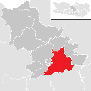
| Location of Feldkirchen in the Feldkirchen district | ||
  |
||
 View from Rottendorf to Feldkirchen |
||
| Source: Municipal data from Statistics Austria | ||


Feldkirchen is a town in Carinthia and seat of the district administration of the same district . The large community, which today comprises 86 localities through several community reforms, has 14,270 inhabitants (as of January 1, 2020), making it the fifth largest city in Carinthia. Feldkirchen was first mentioned in a document around 1065/66 and was granted market privilege before 1176. In 1930 the community was elevated to a town.
geography


The city of Feldkirchen is located on the northern edge of the Klagenfurt Basin . The municipality is between 510 m (lowest point on the municipality boundary with Ossiach in the Tiebel stream bed) and 1069 m (highest point, Taubenbühel on the Ossiacher Tauern ), Feldkirchen itself at about 550 m above sea level. The Tiebel and the Glan flow through the municipality .
Three stagnant bodies of water, the Dietrichsteiner See in the east, the Maltschacher See in the southeast and the Flatschacher See in the northwest, are also located in the municipality.
City structure
The localities of the municipality are divided into the following 12 cadastral communities :
Carnival
Feldkirchen
Glanhofen
GradischHoefling
Klein St. Veit
Pernegg
RabensdorfSt. Ulrich
parakeet
Tschwarzen
Waiern
The municipal area comprises the following 86 localities (population in brackets as of January 1, 2020):

- Adriach (11)
- Agsdorf area (11)
- Aich (19)
- Silly (37)
- Alps (10)
- Evil paints (113)
- Briefelsdorf (215)
- Book sheaths (104)
- Debar (39)
- Dellach (169)
- Dietrichstein (8)
- Dobra (21)
- Dolintschig (54)
- Eberdorf (26)
- Egg (59)
- Elbling (25)
- Farcha (49)
- Carnival (11)
- Feistritz (194)
- Feldkirchen in Kärnten (2830)
- Foerolach (13)
- Glan (97)
- Glan Sight (84)
- Glanhofen (279)
- Gradisch (12)
- Guttaring (19)
- Haiden (454)
- Hard (56)
- Courtier (300) including courtier settlement
- Ingelsdorf (107)
- Kallitsch (53)
- Klachl (49)
- Klausen (47)
- Little St. Veit (105)
- Kofl (15)
- Krahberg (234)
- Kreuth (39)
- Laboisen (447)
- Lang (29, from Alpine Slavonic * lǫka: wet meadow )
- Linen (104)
- Guide (74)
- Lendorf (88)
- Liebetig (115, from Alpine Slavonic * L'ubotik'e, which is interpreted as the place of the descendants of L'ubota )
- Lindl (829)
- Maltschach (75)
- Landmark (523)
- Mattersdorf (49)
- Metzing (189)
- Micheldorf (139)
- Naßweg (60)
- Niederdorf (87)
- Oberglan (436)
- Pernegg (33)
- Persching (53)
- Poitschach (45)
- Poitschach barracks (0)
- Poitschachgraben (4)
- Pökelitz (2)
- Pollenitz (19)
- Powirt Chess (102)
- Pregrad (106)
- Praschig (3)
- Rabensdorf (191)
- Cycle path (315, Slovak Radoviče)
- Raunach (42)
- Rennweg (6)
- Rottendorf (125)
- Seitenberg (70)
- Parakeet (103) including the parakeet
- Sonnrain (196)
- St. Martin (260)
- St. Nikolai (134)
- St. Ruprecht (933)
- St. Stefan (104)
- Ortisei (582)
- Stocklitz (111)
- Strußnighof (4)
- Tramoichy (147)
- Black (89)
- Unterberg (48)
- Lower Glan (87)
- Lower Rain (43)
- Wachsenberg (27)
- Waiern (1022)
- Wide (40)
- Zingelsberg (12)
Neighboring communities
| Himmelberg | Steuerberg | Santa Urban |
| Steindorf |
.svg)
|
Glanegg |
|
Ossiach Velden |
Techelsberg | Moosburg |
history
First settlements

The area around today's Feldkirchen, in the Glantal and on the Ossiacher See has been sparsely populated since the later Neolithic period (around 2000 BC). For the 5th century BC A fortified settlement on the Krahberg is proven, which was established by the Celts in the 3rd century BC. Was taken over. During the time of the Kingdom of Noricum , the flat valley areas were gradually settled. A well-fortified sanctuary stood on the site of today's Tiffen Church of St. James . The place name “ Tiffen ” is derived from the Celtic “Tif” (swamp), and the name of the Glan (“the louder, clear”) is of Celtic origin.
Antiquity and the time of the Great Migration

The Romans occupied Noricum in 15 BC. And subsequently expanded the previously primitive road system. For the Roman Feldkirchen it can be assumed that it is the Beliandrum street station. The Via Julia Augusta leading from Aquileia north over the Plöckenpass into the Drautal ran via Irschen ( castrum Ursen ) - Spittal ( Teurnia ) - Krastal - Treffen and Feldkirchen ( Beliandrum? ) To Virunum . As from Teurnia, the Roman road Virunum - Iuvavum branched off from Feldkirchen in the north to Salzburg ( Iuvavum ).
From the 4th century AD, starting from Aquileja , Christian teaching spread in the Roman province of Noricum. An indication that there could have been a Christian community in the Feldkirchen area around the year 400 is the gravestone of a Roman woman named Valerina, on which a Christogram cross is depicted.
During the migration period in the 5th century, numerous settlements were devastated and plundered by migrating Germanic tribes. In the 6th century, many of the still resident Celto-Romans withdrew to more remote valleys, besieged by Slavic settlers. Shortly before 600 AD, Slavic warrior nobility also moved into the country and founded the Principality of Carantania . Slavic settlers cleared terraces at various points in the Feldkirchen basin and established closed settlements there. Several field, place and river names in today's municipality are therefore of Slavic origin. B. Poitschach (from poljanica , "small plain"), Powirtschach (from podvorcice , "two courtyards ") or Tscherneitsch (from crnejec , "the black one").
Early Middle Ages

In the 8th and 9th centuries, forests were cleared to create more settlement and cultivation areas, preferably on higher slopes, as the swampy and densely wooded area in the valleys was not suitable for settlement. Around the middle of the 8th century, a second wave of Christianization began in Carantania , this time coming from the diocese of Salzburg and aimed at the “conversion” of the Slavs (in this context, the texts of the Freising monuments that were later written down, and consequently one on the Alpine Romance- based Alpine Slavonic / Slovenian Christian terminology created). As a result, the first “church in the field” was built, which, along with the associated settlement, is mentioned for the first time in a deed of donation dated December 26, 888 as “Ueldchiricha”; however, this document was forged around 1065/66.
After the Benedictine monastery founded in Ossiach (before 1027) and Millstatt (around 1070), extensive possessions in Carinthia were given to the church. The bishopric of Bamberg , which was only founded in 1007, was generously endowed with land in Carinthia ( Villach with the Kanaltal , Feldkirchen and Wolfsberg with the upper Lavanttal ) and thereby gained considerable influence. The area around Feldkirchen belonged to Bamberg until 1759. Feldkirchen and surrounding towns such as Steindorf and Glanegg benefited from its favorable location on the Vienna-Styria- St. Veit- Villach-Venice trade route from the middle of the 11th century. The castles Dietrichstein , Prägrad , Tiffen and Glanegg were built along this important road around Feldkirchen . The construction of a number of Gothic churches in the region also fell during the period of economic growth, which lasted until the middle of the 13th century.
Development of the market
As early as 1176, Feldkirchen was first mentioned as a market (lat. Forum ), which was designated as a separate legal area and was thus outside the sphere of influence of the Carinthian duke. For a market in the full legal sense, however, there was still no civil self-administration by a council and a freely chosen judge, market seal and coat of arms as well as a weekly and annual market. The market judge, for example, who was also burgrave of Dietrichstein, was chosen by the Bamberg bishop from the circle of knightly feudal people, and efforts by the citizens to free judges were suppressed by the diocese at the end of the 14th century.
In 1434 Feldkirchen and Dietrichstein were pledged to Pankraz Ungnad . His family, who came from the Lavant valley, was originally in Bamberg's service, but they also provided some military commanders and officials of the emperor and thus gained wealth and prestige. During the time of Ungnad's rule, which lasted until 1468, the Feldkirchen market became independent as a civil parish, which was mainly due to Ungnad's close relationships with the Habsburg rulers. In 1441 King Friedrich IV put the Feldkirchen citizens on an equal footing with those of the sovereign markets and towns in terms of trade and commerce, in 1453 Feldkirchen was granted the right to a fair and was exempted from the jurisdiction of foreign judges. From 1459 the market also had its own coat of arms and in 1468, Christoph Ungnad finally gave the citizens their own market organization, which regulated numerous areas of everyday life. In the same year, the Bishop of Bamberg bought Feldkirchen back from the pledge.
The following decades were marked by attacks, first by the Turks and later by the Hungarians, who plundered and set fire to Feldkirchen as well as the upper Gurktal, the Sirnitz, the Glantal and settlements around Lake Ossiach. Although many churches were expanded into fortified churches during this time, and the Bamberg Amthof was fortified and offered protection to the population, the Feldkirchen marketplace was unfortified and therefore defenselessly exposed to attacks.
The economic decline caused by looting and temporary occupation was followed in the 16th century by an economic rise in the region around Feldkirchen, which was mainly based on the processing of the iron ore extracted in Hüttenberg . The iron processing companies shaped trade and industry in the region until the 20th century. The fact that the old trade route via Feldkirchen and Villach to Venice had become meaningless after the victory of the Habsburgs over the Turks and the subsequent shift of the economic heavyweight and the trade routes to the east meant a setback for the Feldkirchen market.
After the Bamberg bishop had already renounced sovereignty over his dominions in Carinthia in 1675, all of the bishopric's possessions, including the Feldkirchen market, were sold to the Habsburgs in 1759 .
Formation of the local church and the district

In 1846 the Lower Austrian industrialists Matthäus and Franz von Rosthorn took part in the ironworks in Buchscheiden near Feldkirchen, which were operated with peat. Railway tracks were produced here. The ironworks in Buchscheiden was sold in 1870 after insolvency and compensation.
After the revolutionary year of 1848 , which caused little excitement in Feldkirchen itself, the municipal law of March 17, 1849 created the prerequisites for the formation of local political communities. The starting point for this was the cadastral communities that already existed at the time , but the approach in Carinthia was very inconsistent. Especially in Upper Carinthia, very large communities were created, so the community of Feldkirchen, formed in 1849, already had around 60 km² and around 4500 inhabitants, with the inhabitants of the market dominating politically. Some localities were therefore dissatisfied with this division and split off again: Steuerberg became independent communities as early as 1866 and Waiern in 1894.

With the formation of municipalities, district courts and district authorities were also created. Each municipality in Carinthia was assigned to one of the 28 new district courts, which in turn was assigned to a district authority. Feldkirchen received a district court to which the communities of today's Feldkirchen district were subordinate, but no district administration of their own, but was subordinated to the Klagenfurt-Land district. The municipalities of the Feldkirchen judicial district tried repeatedly in joint petitions to the state government to have their own district authority set up. This goal could not be fully enforced, but with a decree of March 18, 1903, the Ministry of the Interior approved the establishment of a Political Expositur in Feldkirchen, which began its work on October 1 of the same year. The political commissioner received a large part of the authority of a district captain, but was bound by the instructions of the Klagenfurt district captain. It was not until January 1, 1982, when the state government decreed the “formation of a political district of Feldkirchen” that the district of Feldkirchen was formed . The official building in Milesistraße had already been occupied by the provisional administration in 1963.
The First World War and the consequences
Feldkirchen was a long way from the battlefields of the First World War, but during the time and especially after the end of the war, its effects were also visible here. After Italy entered the war in 1915, refugees from the Gail Valley and the Canal Valley had to be accommodated in Feldkirchen . After the front collapsed in 1918, soldiers and refugees streamed north. Feldkirchen temporarily resembles a camp with thousands of people, wagons and horses. Immediately after the end of the war, the newly formed SHS state (later the Kingdom of Yugoslavia ) tried to annex part of Carinthia. In the course of this, troops briefly advanced to the southern municipal border at Radweg and Klein St. Veit, but soon moved back to behind Klagenfurt. The referendum in Carinthia in 1920 brought the acts of war to an end. However, the economic consequences of the war continued well into the 1920s.
On the occasion of the ten-year anniversary of the referendum, the state government elevated Feldkirchen, along with four other communities, to the status of town in 1930. Soon afterwards, the tense economic and political situation resulting from the global economic crisis also affected Feldkirchen. The NSDAP, mocked as “cockchafer” at their Feldkirchen party congress in 1929 because of their brown uniforms, and the communists gain popularity in the early 1930s, party meetings are monitored by the police. In 1934 the political tensions in Austria escalated into violent, civil war-like clashes, in Feldkirchen insurgents fought with gendarmes and members of the protective corps, in which a gendarmerie officer was killed. The uprising was suppressed, but the economic situation remained bleak.
National Socialism, World War II and the Post-War Period
After Austria's " annexation " to the German Reich in March 1938, the referendum on April 11 in Feldkirchen showed 99.73 percent approval for integration into the "Greater German Reich". The Feldkirchener Hauptplatz was renamed Adolf-Hitler-Platz. The economy seemed to be gradually recovering , helped by the abolition of the customs border and the thousand-mark barrier . The Feldkirchen district was spared from the Second World War due to its remote location and few industrial plants - in Poitschach, however, there was a well-camouflaged aircraft engine plant. In 1945 the front moved closer and closer, but no bombs were dropped on Feldkirchen.
After the capitulation, Austria was occupied by the British, and camps were set up in the Feldkirchen area alone for up to 40,000 men and 7,000 horses at times. The city itself became the seat of a British military command. Feldkirchen was temporarily almost cut off from the outside world, initially there was no rail traffic, almost no cars and fuel. The district authorities were only gradually re-established, at the beginning of the 1950s there was brisk construction activity, and in 1959 the foundation stone for the subsequent revival of tourism in the region was laid with the construction of the Ossiacher Bundesstraße from St. Veit via Feldkirchen to Villach Feldkirchen placed.
Second half of the 20th century and present
In the course of community reforms, the urban area was again considerably enlarged through the incorporation of the previously independent communities Waiern (1964), Sittich , Klein St. Veit and Glanhofen (all 1973) and reached its current size of around 77.5 km². On the occasion of the regional reform, the name of the market town was expanded in 1973 to include the addition "in Carinthia".
population

According to the 2001 census, of the 14,030 inhabitants of Feldkirchen at the time, 94.1% were Austrian, 1.2% Bosnian and 1.1% German citizens. 77.1% of the population supported the Roman Catholic , 12.0% the Protestant and 0.8% the Orthodox Church , 2.0% were of the Islamic faith, and 5.1% had no religious affiliation.
Culture and sights
Sacred buildings
City parish church of the Assumption


The predecessor of today's parish church of the Assumption of Mary ("Maria im Dorn") in Feldkirchen was a separate church of the noble family of Eppenstein and was first mentioned in a document in 1065/66. The basilica was built after 1166, when Feldkirchen became part of the Bamberg diocese , and Feldkirchen was first mentioned as a parish in 1285. In the 15th century it was expanded into a fortified church on the occasion of the Turkish and Hungarian invasions . The parish church was a royal Bamberg, where the market remained until 1759, today it belongs to the diocese of Gurk .
The church is a three-aisled Romanesque pillar basilica with a choir square from pre-Romanesque times, a Gothic choir and baroque tower. The east choir tower complex also indicates its great age. Shortly before or after 1200, the Romanesque building with flat-roofed naves and apses took place. The Gothic choir, which belongs to the Friesach choir group, was built around 1340. Around 1500 the ships received late Gothic net and star rib vaults. Romanesque and Gothic frescoes testify to the formerly picturesque interior of the church. In the baroque era, the tower was given its present form and the church its furnishings. The western vestibule comes from the late Biedermeier period.
Further church buildings in the parish area
- The branch church of St. Michael in the south of Feldkirchen, first mentioned in documents in 1387, is a Gothic style church that was redesigned in Baroque style at the beginning of the 19th century. It has a retracted choir and on the north side a tower with arched windows and a baroque onion helmet. The sacristy is built into the corner between the tower and the choir. Above the portal on the west facade is a wall painting that was attached in the 18th century and depicts the church patron. The Roman tomb of Aurelius Sura is walled into the outer wall of the end of the choir. The interior of the church is designed as a two-bay nave with a barrel vault supported by wall pillars and stitch caps. The choir is raised by one step and covered by a ribbed vault. All three altars of Michael’s Church are designed in the neo-baroque style of the 19th century.
- The branch church of St. Philipp and Jakob on the southern outskirts of Sittich was built in Gothic style and first mentioned in 1438. The most striking feature of the church is the widely visible tower with onion dome. The flat-roofed nave has arched window openings, and a 15th-century St. Christopher fresco was discovered on the south side of the nave. The two-bay, mesh-vaulted choir has a 3/8 end and is two steps higher than the nave. The three altars and the pulpit date from the last quarter of the 17th century.
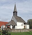
- The St. The Catholic branch church of Stocklitz , consecrated to Leonhard , is a small Gothic church of Romanesque origin.
- The the St.. Nicholas parish church, dedicated to St. Nicholas is a small, Gothic and surrounded by a defensive wall Church. The oldest documented mention comes from the year 1353. In 1954 it was extended to the west.
- The branch church St. Martin in St. Martin is also a Gothic, but essentially Romanesque church building, which was first mentioned as a church in 1136. From 1519 to 1750 St. Martin was an independent parish.
The Catholic branch church in Stocklitz

Parish Church of St. Nicholas in Sankt Nikolai


- The parish church in Ortisei is a Romanesque choir tower church and was first mentioned in 1144.
- The subsidiary church of St. Lambert is located in the village of Hart and is remarkable for its frescoes and other art-historical treasures.
- The Evangelical Trinity Church , which was inaugurated in 1853, is located in Waiern .
- The Filialkirche Hll is in Rottendorf . Wolfgang and Magdalena . The former fortified church was built at the end of the 15th century in the west of the hamlet on a protrusion of the pollen peak slope.
- To the east of Poitschach Castle is the branch church of the 14 helpers in need from the 18th century
- Parish Church of Our Lady in Klein Sankt Veit

Parish Church of St. Ulrich

St. Lambert in Hart

St. Lambert, interior view

Branch church St. Wolfgang and Magdalena in Rottendorf

Parish Church of Our Lady in Klein Sankt Veit


More plants and wayside shrines
- The Tschachitsch church ruins are located west of Turracher Strasse in Waiern .
- The Kalvarienberg-Anlage in the south of the city, at the foot of the Pollenitzen.
- The Kölbl Cross in Maltschach. According to legend, it was originally built to commemorate a servant who was injured in a church tussle in Stocklitz and who collapsed here dead. It has since been renewed several times.

The Calvary Complex

Crucifixion group in the chapel of the Calvary complex

The Kölbl Cross in Maltschach


Secular buildings
- The cityscape is characterized by representative town houses from the 19th century.

View into the Kirchgasse

Former Lebzelterhaus, Rauterplatz 3

Gross-Haus, Gurktalerstraße 26, built by Franz Gross in neoclassical style (around 1890)

Large house, section of the facade of the large house


.jpg)
.JPG)

- Today's castle-like, four-winged building of the Bamberg Amthof goes back to a building complex built in the 13th and 14th centuries, which served as the seat of the ministerial responsible for the administration of the Feldkirche, which was owned by the Bamberg diocese . The oldest documented mention of Feldkirchen as the "tower" - at that time the building consisted of a massive two-storey residential tower, which today forms part of the north wing - dates back to 1422. Today the Amthof is used as a culture and event center among other things a music school and the city museum are housed. Cultural events take place in the covered inner courtyard, and exhibitions by local and internationally known artists are shown in the gallery rooms and in the dungeon-like "Gwölb".
- The Burg Dietrichstein built the 12th century in the 11th or early on a forested hill east of Feldkirchen. A document is mentioned from the year 1103. From 1166 it was owned by the Dietrichstein family . It was destroyed in the course of the Turkish invasions in 1483. After several changes of ownership, the castle finally fell into disrepair, so that today only a few remains of the wall are preserved. Dietrichstein Castle, which is still preserved today, was built by the Dietrichstein family around 1500. After several changes of ownership, it came back into the possession of the Princes von Dietrichstein in 1838 and was redesigned by them in a late classicist form.
- In the district of Prägrad there are the remains of a medieval castle, the ruins of Prägrad , in an unusual location on a ledge in a slope of the Ossiacher Tauern . The time of the original construction is unknown, in 1166 the castle became the property of the Bambergers. In 1628 it finally became the property of the Ossiach monastery through sovereign and then Habsburg property . Only a few parts of the original castle complex have survived.
- The long (g) Castle is located in a small park in the town district field Kirchen. It was first mentioned in a document in 1306. For the year 1440, the Pybriacher family is the oldest evidence of an owner, so the castle belonged to the Himmelberg rule at that time . The two-storey building, which received its current facade in the 19th century, changed hands frequently and is still privately owned today.
- The 18th century Poitschach Castle is located in the north of the city.
- Between Feldkirchen and Tiffen, the Galgenbühel rises south of the federal highway 94 with a remnant of the wall of the former high court.

Lang Castle

The Galgenbühel in the west of the city

Ruins of the former high court on the Galgenbühel


.JPG)
Fountain

The bowl fountain on the Rauterplatz

The Milesi Fountain in the north of the city
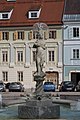
The fountain in the main square


societies
Sports
Gymnastics clubs became very popular at the end of the 19th century. A “General German Gymnastics Club” was founded in Feldkirchen in 1891, but very little is known about its early years. After the First World War, comparative competitions were held with clubs from outside Germany, including in now unknown sports such as "bullet shock" or "courier run" (a relay race). The 1920s and 1930s were a heyday for the club, from which a number of successful gymnast personalities emerged. After the Second World War, the athletics department initially resumed competition. The gymnastics business did not start again until 1957, in the same year the club was given its current name “Allgemeine Turnerverein Feldkirchen” (ATV). Soon after, a tennis department was set up. The athletics section in particular has enjoyed national success in the last few decades.
In 1977 some of the active members split off from the ATV and founded the "Gymnastics and Athletics Club" (TLC). Just two years later, Alfred Markowitsch won the first Austrian championship title for the club in the 400 m run, which is to be followed by around 100 more to this day. The most successful athlete of the TLC to date is the hurdler Herwig Röttl , who competed twice in the Olympic Games ( 1992 and 1996 ) and a total of 14 times in World and European Championships for Austria.
Another nationally successful club is SV Feldkirchen . It was created in 1948 from the merger of the Workers' Gymnastics Club (ATUS) founded in 1924 and the then still young club “Blau-Weiß Feldkirchen”. The footballers of the sports club were promoted to the Carinthian League for the first time in 1958/59. In the 2007/08 season, the first soccer team to compete under the name SV Wigo Feldkirchen in the third-class regional league center achieved their best result so far with 2nd place.
The basketball club ASKÖ Sparkasse Feldkirchen was founded in 1971 by five committed secondary school teachers. By paying more attention to the youth work, numerous Carinthian championship titles could be achieved in the various youth classes. The first championship title was won in 1979 under the coach of the ex-international Hans Orel . In the absence of a suitable sports hall, however, the promotion to the Bundesliga was foregone. Twelve years later, the Feldkirchner were again first in the Carinthian league, promotion to the Bundesliga B was fixed. Home games still had to be played away in St. Veit an der Glan . The club soon moved back to the Carinthian League, where it was the men's championship from 1998 to 2002 and from 2003 to 2007. In 2008 and 2009 the men's team reached the “small final”.
The association has more than 100 members, the majority of whom are girls and boys of all ages.
In addition, there are numerous other sports clubs in Feldkirchen, the spectrum ranges from team sports (ice hockey, handball, volleyball) to cycling and motor sports, several rifle clubs and gliding.
Economy and Infrastructure

Established businesses
The majority of the companies located in Feldkirchen are small businesses: of the 706 businesses recorded in the 2001 census of workplaces, 644 employed fewer than 20 employees, and only five had more than 100 employees.
The largest employer in the municipality is Diakonie de La Tour, which runs a hospital and a nursing home in Waiern. The steel construction company Haslinger, the prefabricated house manufacturer WIGO-Haus and the IT accessories manufacturer Embatex AG (brand name Emstar ) are among the few larger and nationally known companies in Feldkirchen .
Several smaller companies are located in the woodworking and processing industry. These are usually timber construction companies, carpenters and joineries.
traffic
Feldkirchen station is a station on the St. Veit an der Glan - Villach railway line ( ÖBB timetable image 650), which is also part of the historic Rudolfsbahn . Another stop on this route is the St.Martin-Sittich train station in the municipality.
There is a larger bus station in front of the train station, which is served by numerous bus routes in the region.
Feldkirchen does not have a motorway connection, but is the junction of three "federal highways " :
- The Gurktal-Straße (B 93) runs from Feldkirchen in a northeastern direction through the middle Gurktal via Weitensfeld and Strasbourg to Althofen .
- The Ossiacher Straße (B 94) connects Feldkirchen with St. Veit and Villach
- The Turracher Straße (B 95) runs northwards through several municipalities in the district via the Turracher Höhe into Styria , eastwards to the Wörthersee and to Klagenfurt .
In addition, three regional state roads run through the municipality:
- Ossiacher-See-Südufer-Landesstraße (L 49)
- Goggausee-Landesstraße (L 80)
- Ossiacher-Tauern-Landesstraße (L 47)
The Feldkirchen / Ossiachersee (LOKF) airfield is located in Rabensdorf and is operated by the Feldkirchen Ossiachersee aviation club .
education
history
Until 1820 there was only a small schoolhouse in Feldkirchen near the parish church with a classroom, a second class was housed in a private house. A year later, with the support of the community and Count Egger zu Treibach, a new school building with two rooms and a teacher's apartment was set up in Kirchgasse. At that time school fees had to be paid for a third grade, which was viewed by many as a useless expense. In 1869, school lessons were thoroughly reorganized with the Reich Primary School Act. The Feldkirchen school has suffered from space problems since its inception - in some cases it was even switched to inns - which were only resolved in 1910 when the community school moved into. After a further reform at the end of the 1920s, the community school was renamed Hauptschule.
After the Second World War one was confronted with space problems again. In addition, a vocational school and a one-class special school were set up and housed in the primary school building. An additional new building did not provide temporary relief until 1962. The baby boom in the 1960s soon made it necessary for another main school building, which was completed and occupied in 1972. At that time there were over 2000 secondary school students in Feldkirchen. In 1970, with the commercial school , another school had already started teaching in the building of the former community school. A Bundesrealgymnasium was set up in 1979 as a general education high school (AHS).
Today's educational institutions
In Feldkirchen today there are six elementary schools and two new middle schools (focus: IT or sport; Italian or music; musically creative) as well as a general special school . A one-year polytechnic school , the Realgymnasium (BRG) as well as the commercial academy and commercial school are available as secondary schools . There is also a music school located in the Bamberg Amthof.
Feldkirchen has been one of the four locations of the Carinthia University of Applied Sciences since 2002 . Here courses in the field of "health and social affairs" are offered.
There has been an adult education center in Feldkirchen since 1957 .
In the district of Waiern there is the Martin Luther College of the Evangelical Diakonie Carinthia, in which employees of the social institutions of the Evangelical Church are trained.
Health and social
- Pharmacies: In the city of Feldkirchen three pharmacies offer their services.
- Doctors: General practitioners, specialists and the Waiern hospital run by the Diakonie are available to provide health care for the population .
- Care and care: Various organizations offer mobile care services up to 24-hour care for old people and those in need of care. The Diakonie Kärnten , the Carinthian Caritas and the Sozialhilfeverband Feldkirchen operate four homes for the elderly and nursing homes in Feldkirchen.
politics
- Municipal council
The municipal council of Feldkirchen has 31 members and has been composed as follows since the municipal council election in 2015 :
- City council
The city council consists of 7 members and consists of the following city councils:
- Mayor. Martin Treffner, ÖVP
- 1st Vice Mayor Karl Lang, SPÖ
- 2nd Vice Mayor Siegfried Huber, ÖVP
- City council. Herwig Röttl, SPÖ
- City council. Renate Dielacher, SPÖ
- City council. Andreas Fugger, SPÖ
- City council. Herwig Tiffner, FPÖ
- mayor
- until 2015 Robert Strießnig (SPÖ)
- since 2015 Martin Treffner (ÖVP)
coat of arms

The coat of arms with the church in the field shows the parish church Maria im Dorn as a basilica with a choir tower and the Romanesque Karner built southeast of the church .
Feldkirchen was originally awarded during the time under Pankraz Ungnad , temporarily owner of the Dietrichstein fortress and the market, when King Friedrich IV granted the market trading rights (1441) and a fair privilege (1453). The oldest surviving market seal on a document from November 7, 1541 contains the year 1459. Around 1530/40 a smaller city seal was made (preserved in a document from 1542), which remained in use until the 18th century and, among other things, the basis formed for the new award of the coat of arms from 1969. The official blazon of the coat of arms reads:
- In a shield divided by blue and green, a stone-slab-roofed silver church with a tower above the choir square and a carved portal alongside; before the end of the choir a round silver charnel with a conical roof.
The Feldkirchen flag is blue-white-green with an incorporated coat of arms.
Town twinning
- Bamberg , Bavaria, since October 1, 1993
- Ahrensburg , Germany, since February 13, 1998
Personalities
- Franz Jänggl (around 1650–1734), master builder
- Simon Sasslaber (1673–1740), master stonemason and sculptor
- Franz Anton Pilgram (1699–1761), architect
- Ambros Scharfegger (1866–1939), politician ( CSP ), born in Kallitsch
- Hermann Allmayer (1900–1977), journalist, mainly with organs of the NSDAP and SPÖ
- Otto Maria Polley (1910–1984), writer, born in Feldkirchen
- Hubert Wilfan (1922–2007), sculptor, born in Feldkirchen
- Günther Domenig (1934–2012), architect, buried in Feldkirchen
- Reinhold Durnthaler (1942–2017), bobsledder
- Herbert Gantschacher (* 1956), theater director, producer and author, born in Waiern
- Oskar "Ossi" Huber (* 1954), singer / songwriter, musician and author
- Wolfgang Knaller (* 1961), soccer player, born in Waiern
- Ulrich Kaufmann (* 1974), filmmaker, video and installation artist
- Sigi Grabner (* 1975), snowboarder, born in Saureggen
- Sven Klimbacher (* 1981), ice hockey player
- Daniel Nageler (* 1986), ice hockey player
- Martin Hinteregger (* 1992), soccer player, born in Sirnitz
See also
literature
- Brigitte Bader: Feldkirchen in Carinthia. Its history in the 19th century. Diss. Geisteswiss. Fac. Univ. Innsbruck, 1980. Printed by Gitschtaler Villach.
- Feldkirchen in Carinthia . Self-published by the municipality of Feldkirchen i. K., 1980 (reprinted 2004), edited by a group of employees under the direction of Wolfgang Putzinger.
- Wolfgang Putzinger: From the Nock Mountains to the Ossiacher See. Self-published / Wulfenia Verlag, Feldkirchen iK 2008.
- Herbert Strutz : Landscape around Feldkirchen. Carinthia Verlag, Klagenfurt 1978, ISBN 3-85378-121-7 .
Web links
- Municipality of Feldkirchen in Carinthia
- 21002 - Feldkirchen in Carinthia. Community data, Statistics Austria .
Individual evidence
- ↑ Statistics Austria: Population on January 1st, 2020 by locality (area status on January 1st, 2020) , ( CSV )
- ^ A b c Heinz Dieter Pohl : The Slavia submersa in Austria: an overview and attempt at a re-evaluation. (PDF) In: .uni-klu.ac.at. Retrieved July 12, 2017 .
- ^ Putzinger: From the Nock Mountains to the Ossiacher See. P. 19.
- ^ Franz Miklosich: The Christian terminology of the Slavic languages. Vienna 1875; Otto Kronsteiner: Virgil as the spiritual father of the Slav mission and the oldest Slavic church language. In: Virgil von Salzburg. Missionary and scholar. Edited by H. Dopsch and R. Juffinger. Salzburg 1984, 122-128;
- ↑ Dehio Kärnten , Vienna 2001, p. 127.
- ↑ Municipal data, 2001 census from Statistics Austria
- ↑ Dehio Kärnten , Vienna 2001, p. 132.
- ↑ Dehio Kärnten , Vienna 2001, p. 78.
- ↑ Dehio Kärnten , Vienna 2001, p. 646.
- ^ Job census by Statistics Austria of May 15, 2001 (PDF file; 18 kB)
- ↑ Flugsportverein Feldkirchen Ossiachersee
- ^ Stadtgemeinde Feldkirchen, health facilities. Retrieved June 23, 2019 .
- ^ Diakonie, Ernst-Schwarz-Haus Waiern. Retrieved June 23, 2019 .
- ↑ Caritas Carinthia, Help & Advice, Care & Care, Retirement Homes & Nursing Homes. Retrieved June 23, 2019 .
- ^ Quoted from Wilhelm Deuer: The Carinthian municipal coat of arms . Verlag des Kärntner Landesarchivs, Klagenfurt 2006, ISBN 3-900531-64-1 , p. 90.
Albeck | Feldkirchen | Glanegg | Gnesau | Himmelberg | Ossiach | Reichenau | Santa Urban | Steindorf am Ossiacher See | Steuerberg